

 It’s been a while since I was last at Pohoiki, also known as Isaac Hale Beach Park. One reason for this is that it’s about as far away from where I live as is possible on the island. But back in July 2016, I went down there at an ungodly hour to board a boat and go see lava flowing into the ocean. I wrote about that trip here and here. At the park were restrooms, picnic tables, and a boat launch ramp protected by a small breakwater.
Last year, Pohoiki was in the news because it was where the flow from the 2018 Kilauea eruption finally ground to a halt, about 100 yards short of the boat ramp. A few days ago, I decided to revisit the park and see the changes that had taken place.
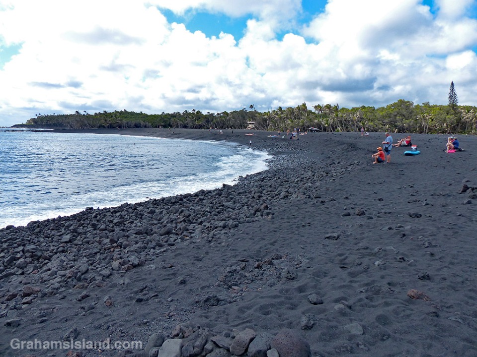
Driving into the park, the cooled lava flow could be seen, stretching down the side of the grassy picnic area (bottom photo). But what I really wanted to see was the boat ramp and the black sand beach at the bottom of the park. They did not disappoint.
The boat ramp, previously used to launch quite large boats, including the lava tour catamaran of 2016, now leads to a small lagoon (top photo). (Note the signs on the left of the photo.) This lagoon is perfect for swimming or sailing model boats, but as a boat launch ramp it has one big drawback. There’s now a long, deep, curve of black sand separating the ramp from the ocean (photo below). This beach began forming during the eruption, but I was surprised by how substantial it was. It’s rocky in places and the sand is quite coarse, but it is unquestionably a beach and it looks like it’s here to stay.
An indication of the beach’s substance can be seen in the second photo. The red triangle on a pole marked the end of the breakwater. Now it’s deep in sand. The breakwater is still there, but almost entirely buried.
The beach was formed by lava pouring into the ocean. Some of it solidified into large chunks, but a lot was quickly broken into smaller pieces and fine sand. (In the postings about my 2016 trip, one of the photos shows a black sand beach forming at the base of the flow.) A good deal of this sand was carried a short way down the coast to form this new beach.
I don’t have a good photo of the park before these changes, but the local newspaper has an aerial view here that shows the features I’ve mentioned. In that photo, the boat ramp, breakwater, and rocky shore can be seen at the bottom. Top left is the restrooms building that is also top left in the bottom photo here. The paths and picnic tables can also be seen.
I’d expect that on my next visit, all these new features that I’ve mentioned will still be there, but there is one caveat. If there’s a new eruption in this area, then everything could change. It’s one of the facts of life of living near an active volcano.
Posted in response to this week’s Friendly Friday challenge on the theme of ‘Revisited.’ See more responses here. Tomorrow, I’ll post a few more photos in response to the Sunday Stills photo challenge.


Pingback: Road across the flow | Graham's Island
How fascinating!
LikeLiked by 1 person
thats a hell of a beach!
LikeLiked by 1 person
It is! I knew it was there, but I was stunned at how substantial it was.
LikeLike
It’s so interesting how instantly everything can change with an eruption. The unpredictability of Mother Nature.
LikeLiked by 1 person
Yes, and it’s so capricious. One home can be wiped out while a neighbor has no damage, like a wicked lottery.
LikeLiked by 1 person
😯
LikeLiked by 1 person
Pingback: Fire In the Sky | The Snow Melts Somewhere
Pingback: Pohoiki fires | Graham's Island
It’s so amazing how the landscape changed. I’d love to visit the Volcanoes National Park again to see all the changes since my last visit in 2013. Thanks for sharing.
LikeLiked by 1 person
There have been big changes to the park, that’s for sure. Halemaumau Crater, at the summit of Kilauea, has suffered huge collapses so what was a fairly flat crater floor (with an active vent in one part) is now deep and jumbled with sections of the road lying in it. Jaggar Museum is right on the edge of the crater and is closed. It might never be able to reopen.
LikeLiked by 3 people
Wow!! Now I want to come back even sooner to see the changes.
LikeLiked by 2 people
That is incredible to hear! Reminds me of the images of Christchurch after the quake. Broken bits of highway sticking up in the air.
LikeLiked by 1 person
Incredible – that barbeque is the luckiest one to escape the lava flow! Fantastic photos and ones that are not readily seen although I do remember some news reports last year. How long after the lava stopped flowing before people could visit the area?
LikeLiked by 1 person
The barbecue caught my eye too so it’s in the next post too. It was a few months after the flow stopped that people could return here, primarily because there were no roads to the area. Different flows had covered all the access roads, but recently they built a temporary road over one of the flows. They won’t do a permanent road until they’re sure the center of the flow has cooled enough to cut through.
LikeLiked by 1 person
So it is still potentially cooling?
LikeLiked by 1 person
I think so. It takes a while. The PBS show, Nova, had a show about Kilauea’s last eruption (worth a watch if you’re interested – you can find it online) and one thing it pointed out was that the first flows from this latest eruption were actually lava left over from eruptions in 1955 and even earlier. The ground is a good insulator.
LikeLiked by 1 person
That is amazing! I had no idea! It makes our own life timeline so insignificant, isn’t it?
LikeLiked by 1 person
Indeed it is.
LikeLike
How interesting that you get to witness such changes, the land evolving all by itself. They say volcanic ground is very fertile, do you think new plants will start growing on that beach or will it stay sandy?
LikeLiked by 1 person
People have already planted coconut palms on the beach, which will help stabilize it, but the beach should stay pretty sandy. It’s a harsh growing environment with all the waves and salt though there are some native plants that will grow in those conditions. I love going to see the different volcanic events. One can get get blase about it because the volcano had been erupting continuously since 1983. It was easy to think, ‘oh, I’ll go down and see the next flow that enters the ocean.’ But each event is different and you never know exactly what you’ll see. When I went to see the firehose of lava (https://grahamsisland.com/2017/02/04/kilauea-volcanos-firehose-of-lava/) I was late realizing it was going on, But I zipped down there the next day and 24 hours later a cliff collapse ended the show.
LikeLiked by 2 people
Getting blase about volcano eruptions really is something!! But understandable
LikeLiked by 1 person
One factor is that many of the flows that preceded this last eruption didn’t do a huge amount of damage so they become thought of as more of a spectacle rather than a danger.
LikeLiked by 1 person
Wow!
LikeLiked by 1 person
It’s amazing to see where the lava flowed here, Graham. The black sand being formed looks so rich!
LikeLiked by 1 person
Yes, it was interesting to see it in the flesh as it were. And yes, that sand is rich in minerals. Volcanic soil is great for growing things.
LikeLiked by 1 person