Tag Archives: Hiking

Kalopa State Recreation Area

I recently went hiking in the Kalōpā State Recreation Area, not far from Honoka’a, on the northern end of the island. I’d been there before, but only to check it out, so this was an opportunity to explore the trails more thoroughly. One of the treasures of this area is that it features plants that were on the island before even the native Hawaiians arrived.

The recreation area is about 100 acres, and it neighbors the 500 acre Kalōpā Forest Reserve. At an elevation of around 2,000 feet, and on the wet side of the island, it’s cool and damp. There are a variety of trails that intersect and criss cross, which allows hikers options from short loops of less than a mile, to a 6+mile hike around the perimeter.

I took one of the longer routes and it reminded me greatly of hikes I’d taken back in the Pacific Northwest where I used to live. Light rain, water dripping from the overhead canopy, ferns bordering the trail, and tall trees stretching up into a grey sky. These were all features of those hikes. Only the species were different. Eucalyptus, ohia, and kopiko instead of firs and cedars.

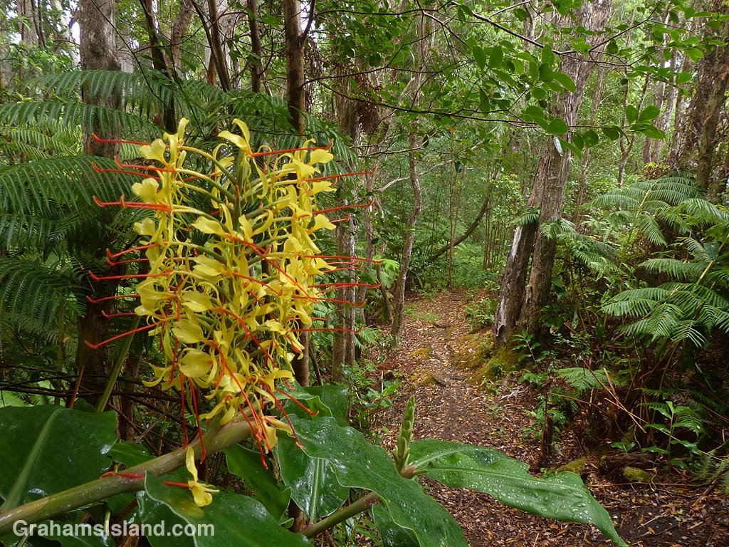
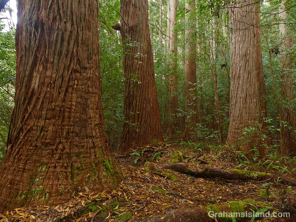
The photos show – Top: towering trees line the trail alongside Kalōpā Gulch. Above: A view down into Kalōpā Gulch. Flash floods often race down this gully so it’s a good idea to watch your step. Third photo: Strangler figs envelope native trees and take over resulting in weird, twisted shapes. Below: The old Jeep Road, bordered by invasive kahili ginger, cuts through the center of the area. It’s hard to imagine anyone driving this trail.

For more information about hiking in Kalōpā State Recreation Area go to bigislandhikes.com/kalopa-state-park/.

Signs: Ka’awaloa Trail

The Ka’awaloa Trail starts near the top of Napoʻopoʻo Road, on the edge of Captain Cook – the town that is, not the person. The trail goes down to the water near the Captain Cook Monument on Kealakekua Bay.

As you can see, there are a lot of warnings on the sign. It could be greatly shortened to, “Abandon hope all ye who set foot on this trail.” But there are a couple of things to know about this sign. One is that most people won’t read it. I mean, who needs to waste time reading a dumb sign. The second is that quite a few people will end up in difficulty on the way back up, because the trail really is steep, hot, and exposed. Locals often take extra water with them to help out those in need, but if you don’t meet one of them on the trail, you’re on your own. An iced tea stand two-thirds of the way up could make a killing.

I also like that someone has taken the time to obliterate the word ‘vehicles’ in the ‘No vehicles’ admonishment. A car would never make it and even a trail bike might have a tough time. Perhaps it was just the principle of the thing that someone objected to.

Red-billed leiothrix

A red-billed leiothrix perched on a branch in a kipuka on the Pu’u O’o trail off Saddle Road. A kipuka is an area of land that has been surrounded by a lava flow. Kipukas often contain older trees and other plants that are a haven for native and non-native birds and other creatures.

This leiothrix had an exceptionally red bill because it was carrying a bit of ripe thimbleberry, presumably to young birds in a nest nearby.

Signs: No parking

I was going to title this, ‘Unclear on the concept,’ but decided not to comment in that way. It’s possible the two drivers didn’t see the sign, or saw it and didn’t care. Either way, they have a reasonable chance of getting away with it. This isn’t a heavily policed area, and even if a cop goes by, there’s a fair chance they’d simply ignore the transgression. The most likely case for something happening is if one of the people who lives in the vicinity complains.

The sign is at the top of a busy trail down to the Captain Cook Monument. A redesign of the road junction nearby created new parking opportunities and this has resulted in a surge in people using the trail. With more use, word gets out and soon the trail will be overused, the shoreline around the monument littered with trash, and the waters and coral in the bay damaged and degraded.

Not that this is the fault of these two drivers, but since they’re clearly breaking the law, let’s blame them for everything anyway.

Pu’u Wa’awa’a views

This week’s Sunday Stills challenge theme is ‘Great Outdoors.’ (See more responses here.) When I think of the great outdoors, I think of hiking, and one of my favorite hikes on the Big Island is up Pu’u Wa’awa’a. It’s an 8-mile round trip and tops out at just under 4,000 feet. On a good day, the hike offers great views, not only from the top, but also on the way up and down. And there are several benches where a person can rest and take in those views, including a couple on the summit.

The top photo shows the view north from around 3,500-feet elevation, with Tamaki Coral in the foreground and Kohala Mountain in the background. The bottom photo is a view from 100 feet or so below the summit looking east toward Mauna Kea.

The hike can also include many native trees and plants as well as a variety of wildlife. There are domestic sheep, cattle, and horses, as well as wild pigs and goats. When the trees are in bloom, they’re rich with insects and birds including several native varieties.

To top it off, most of the times I’ve visited, usually in the early morning, I’ve had the place to myself.

For more information about Pu’u Wa’awa’a and its trails, go to puuwaawaa.org.

Kilauea Iki Trail

This week’s Sunday Stills challenge theme is ‘Paths.’ (See more offerings here.)

Kilauea Iki Trail is one of the more popular trails in Hawaii Volcanoes National Park. But last year’s volcanic activity, with numerous earthquakes, resulted in the park being closed for several months. Even after it reopened in September 2018, many parts of the park remained closed because the areas were too unstable to be opened to the public.

The Kilauea Iki Trail was one of those areas along with Thurston Lava Tube and Jaggar Museum. The latter two locations are still closed and Jagger Museum may never be reopened, but the Kilauea Iki Trail is currently listed as mostly open. Given that this is a loop trail, it would be wise to check ahead and find out what ‘mostly open’ means.

These photos were taken during a hike I took a couple of years back. The top photo shows the view from the part of the trail that follows the rim of the crater before it descends to the crater floor. The second photo shows two hikers heading out across the crater floor. The dark hill in the background is Pu‘u Pua‘i where a 1959 eruption poured lava out into the crater. The third photo shows hikers near the center of the crater where the path winds through broken areas of the crater floor. Below, cairns mark the trail across a flat area of the crater that leads to the switchback trail which takes hikers back up to the crater rim.

For more information about Hawaii Volcanoes National Park, go to nps.gov/havo/.