

At first I thought this was something straight out of Doctor Dolittle, a pushmi-pullyu eel. Alas, no. Instead, it’s two whitemouth moray eels wedged into the same space behind a clump of coral. While whitemouth moray eels are a fairly common sight in the water, this is the first and only time I’ve seen two together. I don’t know whether this proximity was related to breeding. Perhaps they were just helping each other stay warm! Looks like they must be pretty good friends.
Category Archives: Activities
A manta ray glides by

Most weeks I post something in response to the WordPress photo challenge. This week’s theme is ‘evanescent,’ a word I wasn’t familiar with. The definition provided is “soon passing out of sight, memory, or existence; quickly fading or disappearing,” or, put simply, ‘a moment in time.’
To me, this is what any photo is, a snapshot of a given moment. Even the look of a fixed object, a landscape, a building, a monument, is always changing. It could be the light, weather, activity around the subject. Everything is in constant flux, sometimes in obvious ways, sometimes only in the detail. With birds, animals, bugs, even plants – blowing in the wind – those changes of passing moments are more obvious.
So I thought I’d take this week’s challenge as my theme for the week (or at least the remaining six days of the challenge). I start off with this photo of a manta ray. One of the great joys of snorkeling is never knowing what I’ll see that day. It could be a common fish engaged in some activity I’ve never seen before. It could be a glimpse of something unexpected. It could be something seen only at a certain time of year. Whatever it is, it almost always gives me a little jolt of ‘wow.’
While out snorkeling, I got a jolt of ‘wow’ when I saw this manta ray gliding along in the opposite direction. I turned and followed its effortless progress for several minutes until it headed into deeper water and disappeared. An evanescent experience? I think so, though it won’t soon disappear from my memory.
Kalij pheasant


I saw this male Kalij pheasant, with two others, alongside the Powerline Trail, off Saddle Road. I hadn’t noticed them while walking through the trees on the dead-straight trail, but I became aware of a slight but steady clucking sound and stopped to locate it. The birds were picking their way through some dense undergrowth and seemed not the least bit bothered by my presence. Perhaps they were aware it wasn’t one of the days when archery hunting is permitted.
For more information about the Powerline Trail, go to bigislandhikes.com/puu-oo-trail/.
Emesine lava tube
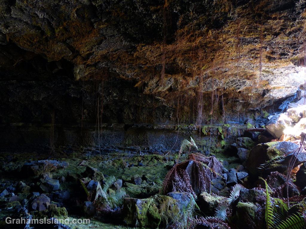
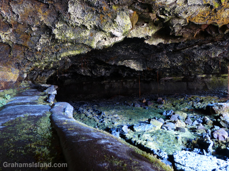
One of the things to look out for on the Powerline Trail, off of Saddle Road, is Emesine lava tube. There’s a sign right next to the trail, though it could be missed if you happened to be looking the other way while walking that stretch. Bear in mind that if you want to explore the lave tube, the sign indicates that you should first get a permit from the State Department of Land and Natural Resources (Division of Forestry and Wildlife).
These photos are from the entrance of the eastern part of the tube, which is the most accessible. The ceiling here is about 4 feet so it’s not for the claustrophobic. Not sure whether it opens up further along, but be sure to take plenty of good lights.
For more information about Emesine lava tube, go to darkerview.com/wordpress/?p=3781.
For more information about the Powerline Trail, go to bigislandhikes.com/puu-oo-trail/.
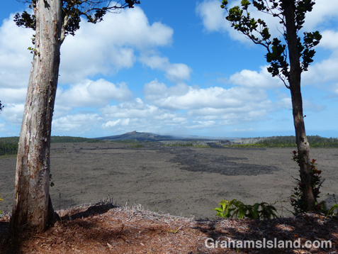
Powerline trail

The Powerline Trail heads south off of Saddle Road around the 22 mile marker. This trail used to be, as the name suggests, where power lines ran, but only the stumps of poles remain. It’s a very straight trail, which used to run all the way to Kilauea until lava flows disrupted it.
This trail is about 3.5 miles long to the point where it meets the Pu’u O’o trail. The southern part of the trail is dotted with kipukas and is shady and alive with birds. However, the northern two miles or so are exposed as the photo shows. The main feature of interest in this stretch is the Emesine Lava Tube about which, more tomorrow.
For more information about this, and other hikes on the Big Island, go to bigislandhikes.com.
The Nāpau Trail – Through the woods


Yesterday, I posted about the first part of the Nāpau Trail in Hawaii Volcanoes National Park, which crosses extensive lava fields. Today’s post picks up from there, on the rim of Makaopuhi Crater, where the trail slips into dense forest on its way to the Nāpau Crater overlook.
It’s a remarkable contrast between the stark lava and thriving forest. Birdsong is continuous. Ferns of every kind grow in abundance. Bamboo orchids pop out here and there. And above it all, tall Ohia trees provide the backbone of the forest. This forested trail is clear, but somewhat overgrown. I was hiking in shorts and, at the end of the day, my legs were generously scratched.
Early on in this section, it’s possible to get views of Makaopuhi Crater. Also in this area is the junction with the Nāulu Trail, which starts out at the Kealakomo Overlook, farther down Chain of Craters Road.
The forested part of the trail is about 2.5 miles and towards the end of it is an old Pulu factory. The sign there reads: “Between 1851 and 1884 great quantities of pulu, the soft, reddish-brown fiber covering the coiled fronds of the tree fern (hāpuʻu), were harvested on Hawaii. Much of it was processed within these walls, later to be shipped from Keauhou Landing to foreign markets for use as stuffing in pillows and mattresses.” Unfortunately, in drier climates, pulu quickly breaks down so the industry collapsed.
A little farther along is another junction. To the left is the very basic Nāpau campsite, a few open flat areas and an outhouse. To the right, the trail continues to the overlook, where I was lucky enough to have a wonderful, clear view of Puʻu ʻŌʻō, busily pumping out sulphur dioxide and other gases, and of course, million upon millions of gallons of lava, currently entering the ocean on the southeast coast.
Picking the right day for the hike is not always obvious and weather changes quickly around here. At the visitor center, on the way in, it was completely overcast and drizzling, but by the time I got to the trailhead the sun was out and a nice breeze blew. The wind direction is also important. On this day, the northeast trades were blowing and the vog trailed away to the southwest, which is fine for this hike. But if the wind blows more easterly or south of east, then this trail would be downwind of emissions from the volcano, which could potentially be a dangerous situation.
For more information about this, and other hikes on the Big Island, go to bigislandhikes.com.
For more information about Hawaii Volcanoes National Park, go to nps.gov/havo/.
For more information about Kilauea Volcano and it’s eruptions, go to hvo.wr.usgs.gov/kilauea/history/main.html.
The Nāpau Trail – Over the lava

The Nāpau Trail in Hawaii Volcanoes National Park, is a 13-mile round trip. It passes over extensive lava fields, plunges into dense forest, and ends at the Nāpau Crater overlook. The overlook offers a terrific view (weather permitting) of Puʻu ʻŌʻō, one of two active vents on Kilauea Volcano. In today’s post I’m going to cover the lava fields portion of the hike with the second part coming tomorrow.
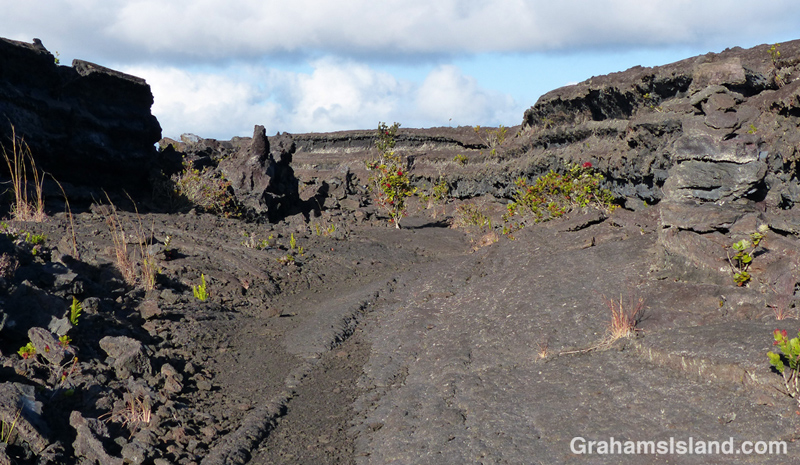
From the Mauna Ulu parking area, the first mile or so is a well-trodden trail to Pu’u Huluhulu (hairy hill) cinder cone. The foot of Pu’u Huluhulu is where the Nāpau Trail branches off across the lava. It’s a stark landscape, but with lots of interest. The trail passes over surface flows and through channels where lava rivers ran.
The Park’s website notes that the Nāpau Trail “follows the path that magma takes as it makes its way underground from its source at the summit to the point where it comes to the surface near Puʻu ʻŌʻō.” The many steam vents around Mauna Ulu are testament to this.
And in this hostile landscape, nature is at work. The lava fields are dotted with tenacious plants establishing a toehold. Ohia trees and ferns are most frequently seen, but grasses and other plants lend color to this sea of gray and black.
It’s 2.2 miles of unbroken lava from the Pu’u Huluhulu junction to the rim of Makaopuhi Crater, but at that point the trail changes in an almost surreal way. I’ll post that section tomorrow.
For more information about this, and other hikes on the Big Island, go to bigislandhikes.com.
For more information about Hawaii Volcanoes National Park, go to nps.gov/havo/.
For more information about Kilauea Volcano and it’s eruptions, go to hvo.wr.usgs.gov/kilauea/history/main.html.


Clown with a parachute

Everyone’s scared of clowns, right? This one appeared attached to the sometime-in-the-distant-future shade tree by Upolu Airport. Presumably it was hung there in connection with the skydivers operating there, but imagine it on your porch, swinging in the breeze, just watching and waiting for your return one dark and rainy night. Dum, dum, dum, dum.
