Category Archives: Parks

Flowing to the ocean

Lava from Kilauea's Pu'u O'o flow.
At twilight, lava flows down Pūlama pali while, at the top of the hill, a smaller breakout can be seen. In the center are two onlookers, illuminated by the glow of flashlights.
Lava from Kilauea's Pu'u O'o flow sets fire to shrubs and trees.
In the early evening, the flow descends the pali, starting fires in surviving stands of trees and shrubs.
The glow of lava from Kilauea's Pu'u O'o flow reflects off the clouds.
As the light fades, the glow from the flow reflects off passing clouds. The white lights are the flashlights of people hiking to or from the flow.
Kilauea's Pu'u O'o flow glows brightly as darkness falls.
The lava flow burns brightly as darkness falls.

In April, I posted here about a trip last year to see lava bubbling up at Kilauea Volcano. That activity was in the Overlook vent of Halema’uma’u Crater. On May 24, Kilauea’s other active vent, Pu’u O’o, began a new breakout of lava toward the southeast. This is a path that flows have taken many times before. The first active lava I saw was back in 2010 when such a flow reached the sea and put on a spectacular show.

This May 24 flow is also headed to the sea. By June 28 it had reached Pūlama pali, a steep slope leading down to the coastal plain. On July 7 it was less than three-quarters of a mile from the ocean, and creeping slowly over previous flows that have taken this path. That’s when I went down to take a look and took these photos.

At its current rate of progress, the flow will reach the ocean in a week. But it could speed up or stop, so it’s really a case of wait and see.

There is one note of irony. I have a map from 1975 showing the road that ran along this coast before being covered by various flows from the volcano. In 2014, a flow from the Pu’u O’o vent headed east, threatening the town of Pahoa and the main highway into that corner of the island. One response to that situation was to bulldoze an emergency highway along the coast, at a cost of $10 million or so, following the route of the old road. It was never used as that flow stopped short of Pahoa. If the current flow travels another a half mile or so, the emergency highway will be covered again without ever being used. Such is life.

For more information about Kilauea Volcano and it current eruption, go to hvo.wr.usgs.gov/activity/kilaueastatus.php.

Lava rises at Kilauea volcano

The lava lake in the Overlook vent at Halema’uma’u Crater.
Kilauea lava crust bubbles and cracks
The slightly cooler surface is broken up by bubbling lava.
A hotspot illuminates the crater wall at Kilauea
A hotspot illuminates the crater wall.
Onlookers at Kilauea
The quiet group reverently looking on had the appearance of a cult at times …
Cult-like gathering at Kilauea volcano.
… Gathered around the mystical ring of fire.

Today marks the anniversary of a trip my wife and I made to Hawaii Volcanoes National Park. That’s where Kilauea Volcano, active since 1983, has two vents spewing lava. Flows from Pu’u O’o vent have, over the last few years, reached to the ocean and threatened to take out the town of Pahoa.

The other vent is in Halema’uma’u Crater. It’s known as the Overlook vent since it’s below an old viewing overlook. Since it became active in 2008, it’s been a bubbling pool of lava, varying from 60 to 400 feet below the floor of the crater. By night the lava glow was visible. By day, mostly what could be seen was steam and smoke.

In early April of last year, the lava lake started rising. It rose so much that the lava became visible from the Jaggar Museum, which gives a good view of the main crater. It was time to check it out. The problem was that the spectacle of active lava visible from an accessible spot led to a crush of visitors. The park warned that large crowds were showing up and advised visiting at off peak times.

Lava viewing is more vivid at night, but the scene in daylight is also interesting, so there were two options. Showing up in the afternoon and staying through sunset would be iffy because it was guaranteed to be crowded. The alternative was to arrive before sunrise and stay until it got light. The only snag? We live 100 miles away.

The day before the trip, we turned in early and I set my alarm for 12:01 a.m. We got up and were on the road by 12:35. Driving in the wee hours was actually pretty nice. The stars were out and the roads mostly empty. In Hilo, we stopped at Ken’s House of Pancakes, the Big Island’s only open-24-hours restaurant, and had breakfast at 2:45 a.m., a slightly surreal experience. Then back on the road before pulling into the viewing area parking lot at the Jaggar Museum a little before 4 a.m.

It was cold with the wind making it feel cooler and we weren’t really dressed for the occasion. But there weren’t too many people there, the night sky was gorgeous, and the lava very visible and active. We watched it bubble and spatter, often vigorously. Daylight crept in. As it did so the scene changed and more people began to show up. By 6 a.m. it was light so we left, getting home just after 8:30. It was strange to think that at that relatively early hour we had driven to the farthest side of the island, watched the volcano for a couple of hours, and driven back. Usually at the time the most I can claim is that I’ve made coffee.

First light silhouettes the onlookers.
As darkness dissipates, lava shoots into the air.
As darkness dissipates, lava bubbles in the crater.

Soon after our visit, part of the crater wall collapsed into the lava causing a big explosion. The lava lake also reached the rim of the Overlook vent and began to spill out onto the main crater floor. We thought these developments were worth making the same trek again. And then the lava went into retreat. It fell back below the rim of the vent. Within days, the lava lake in the vent disappeared from sight and sank back to its former levels, which is where it remains, currently more than 100 feet below the Halema’uma’u Crater floor. (For scale, the active vent opening measures about 500 feet by 700 feet and the distance from the main Halemaumau Crater floor to the rim is about 270 feet.)

For more information about Hawaii Volcanoes National Park, go to nps.gov/havo/. For more information about Kilauea Volcano and it’s eruptions, go to hvo.wr.usgs.gov/kilauea/history/main.html.

Daybreak reveals the onlookers gathered at the Jaggar Museum viewing point.

Kiholo to Mano Point hike

The start of the trail to Mano Point

The start of the trail below the parking area at Kiholo.

The house built for Loretta Lynn at Kiholo.

The house built for Loretta Lynn at Kiholo.

The anchialine pool at Kiholo

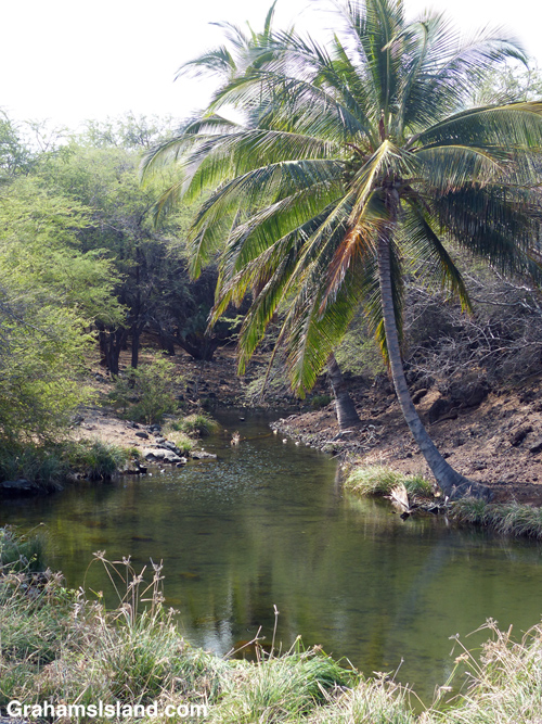
The anchialine pool at the south end of the first beach.

The lava bench before Mano Point

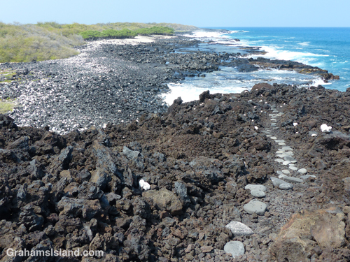
The trail winds down to the bench before Mano Point.

This hike is a not-too difficult, out and back, 4-mile round trip. Aside from wanting to check out this part of the coast, I also wanted to try out a new pair of shoes, more suited to hiking, rather than the old pair of walking shoes I’d been flogging my toes in recently.

The access road to the trailhead can be rough, but on this occasion had been recently graded, at least down to the private road near the bottom. The hike follows the coast south from the Kiholo parking lot. There’s camping here Friday through Sunday, but on this day it was much quieter – three people on the beach when I set out, not many more when I returned. The day was hot, as it usually is on this coast, and the vog was thick enough to chew on.

The hike starts out crossing the first of three black sand beaches. It’s part of Kiholo State Park Reserve, which means it’s a park for which the plans have not yet been finalized. Behind this first beach is a house built by country singer Loretta Lynn back in the 1980s. It’s boarded up now, but is tabbed to be some sort of visitor/cultural center in the new park. Check back in 10 years or so to see how things are going!

At the south end of the beach is an anchialine pool. After the pool, the trail winds up and over a’a lava to another smaller black sand beach. There’s another up and over to the third beach, Luahinewai, which is backed by a large private residence, overlooking another anchialine pool and surrounded by vegetation. The second and third beaches were deserted, the a’a lava lumpy, the new shoes doing a splendid job of cushioning my feet.

After this third beach the trail heads up onto the lava for a while and crosses inland from Nawaikulua Point until it reaches a lava bench backed by vegetation. The trail, which is marked by some rounded stones in the trail and white coral markers on the edges, ends here. Mano Point is reached by crossing the lava bench, which is not difficult but, as always, requires keeping an eye on the ocean. On this day the waves were thudding against the edge of the bench, sending spray into the air and some whitewater onto the bench.

It was a day for keeping toward the back of the bench. A couple of days earlier, when the surf was higher, it would have been a place to avoid altogether. On a calmer day one could walk along the edge of the bench. This is an area of tide pools, arches, and collapsed lava tubes that have become surging inlets.

Mano Point itself is not much of a point, but it is easy to identify because it’s where most of the vegetation ends. It’s also marked by a black-bordered, yellow sign (only the back of which is seen from the land), which I think means that no aquarium fish collection (a contentious issue here) is allowed south of the sign. The return is back the same way. I took a dip in the water at one of the beaches on the way back, but the surge was fierce and I ended up discovering black sand in unlikely places for a couple of days afterwards.

It’s not an earth-shaking hike, but enjoyable in its own way. There was a breeze on the coast as there usually is, some whales to be seen offshore, and my new hiking shoes performed admirably. That said, crossing behind the last beach en route to my truck, I felt a pricking in my foot and took off my shoe to find a kiawe thorn that had penetrated the sole. Not the fault of the shoe though, just an occupational hazard of hiking here.

For more information about the Kiholo to Mano Point hike, go to bigislandhikes.com/kiholo-to-mano-point.


The trail from Kiholo to Mano Point

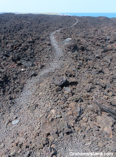
The trail heads across a’a lava after the third beach.

Waves crash ashore near Mano Point

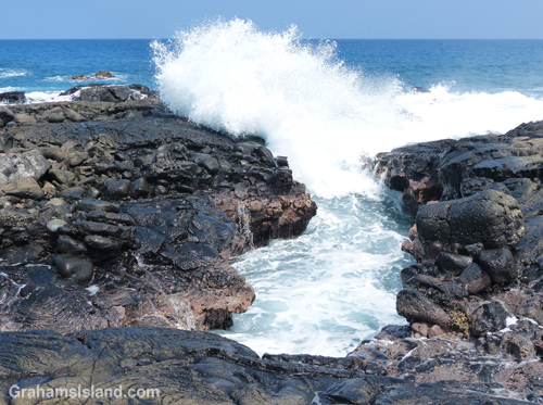
The water surges into a small inlet, probably an old lava tube.

The sign which marks Mano Point

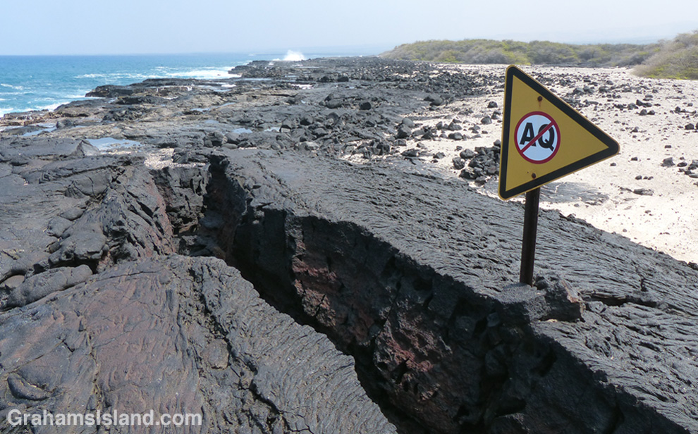
The sign at Mano Point which I think means ‘No Aquarium Fishing.’

Signs: What’s for breakfast then?

What's for breakfast then?A favorite sign of mine at a local state park. Among the usual warnings is the draconian limit on drinking hours. I mean, what’s a person supposed to do for breakfast? It will come as no surprise to know that the rule is routinely ignored and I doubt it’s ever been enforced.

The short, lively life of Elua

Gotta get some rest.
I'm watching out for you.
I’m watching out for you.
Always got to keep an eye on him.
Mom's quick to get Elua's attention.
Mom’s quick to get Elua’s attention.
On the beach.
On the beach.
Tired out again.
Tired out again.
Elua's not shy about making himself heard either.
Elua’s not shy about making himself heard either.

These photos are from November of last year. Not being on social media or especially well connected, it wasn’t until late November that I heard a monk seal pup had been born at Keokea Beach Park. The pup was born November 2 and was named Elua by the local community.

Elua means ‘two’ or ‘twice’ in Hawaiian. He was given the name because his mother, Waimanu (named after the valley where she was born), had given birth to another pup at the same spot two years previously. That pup was named Keokea, after the park. He died in his first year after swallowing a fishhook, a major hazard for monk seals around the islands.

I first stopped by on November 22 and returned on November 25 with a view to joining the volunteers who take shifts to monitor the pup. The idea is that these volunteers provide information about the pup, and monk seals in general, to people visiting the park and try to ensure that the seals aren’t unduly disturbed.

The general consensus was that Elua was doing very well and seemed to be picking things up fast. There was hope the pup would be ready to leave earlier than Keokea had when he was here. Indeed, Elua did seem livelier and more adventuresome, even at this early stage.

On November 26, Thanksgiving Day, Elua was found dead. My understanding is that a necropsy was unable to determine exactly what happened. I heard the cause was ‘blunt trauma’ resulting in edema (abnormal accumulation of fluid) in the lungs. As far as I know, what caused the ‘blunt trauma’ is unknown.

The loss of any pup is serious because there are so few monk seals. They’re a critically endangered species, with a current population of around 1,100. Most live in the northwestern atolls with about 200 around the main Hawaiian islands. In addition, the Hawaiian monk seal has a very low genetic diversity, which makes it potentially very vulnerable to disease and environmental changes.

For more information about Hawaiian monk seals, go to www.pifsc.noaa.gov/hawaiian_monk_seal/ or www.marinemammalcenter.org/hawaii.

Lunch time at last.
Lunch time at last.