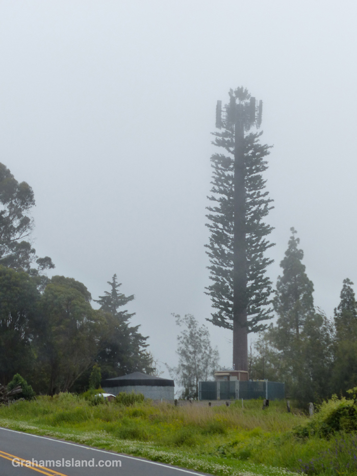
I went for a drive up Old Saddle Road yesterday and noticed this unusual tree. It is, of course, that now ubiquitous invasive species, the cell phone tower. At least this one had the good grace to try and blend into its surroundings, and does a decent job of it.
This ‘tree’ is located on the grounds of Camp Kilohana, the Girls Scouts Camp on the Big Island.
Posted for Bushboy’s Last on the Card photo challenge. See more responses here.
This week’s Sunday Stills challenge theme is ‘Roads, Paths, and Streets.’ See more responses here.
After a recent hike off Saddle Road, I had time to take a drive up one of my favorite roads on the island, which leads to the Mauna Loa Observatory. Well, it used to; it doesn’t get there anymore. That’s because a flow from last fall’s eruption of Mauna Loa crossed the road a few miles short of its destination. I was curious to see what the scene looked like now.
The cloudy skies added some atmosphere to the drive which was, as always, a lot of fun. It’s a winding one lane road, so even though there’s little traffic, one has to pay attention. Any distraction could result in driving off the road into the inhospitable lava fields bordering it.
I confess, my secret hope was that, when I arrived at the flow, there would be a sign saying ‘Road Closed.’ Alas, that was not the case. Clearly, the Department of Transportation figured the seven foot high wall of lava conveyed the message well enough on its own. The only sign there warned against walking on the new flow. I didn’t need that warning. This is a’a lava which is really hard to walk on anyway, and in a new flow it could be quite unstable and even harbor pockets where one could fall through into still hot lava! Still, I’m sure some folks have clambered up there just because it’s there.
I took a few photos, then turned around and headed back down, not least because it was damp, windy and I was freezing, which is not why anyone comes to, or lives in, Hawaii.
On the drive down, I got a good view of the HI-SEAS (Hawai’i Space Exploration Analog and Simulation) dome. This is where teams of volunteers do research for what it would be like to be living on the Moon or Mars. I’m not sure if it’s in use since the COVID shutdown, but at least it survived the last eruption.
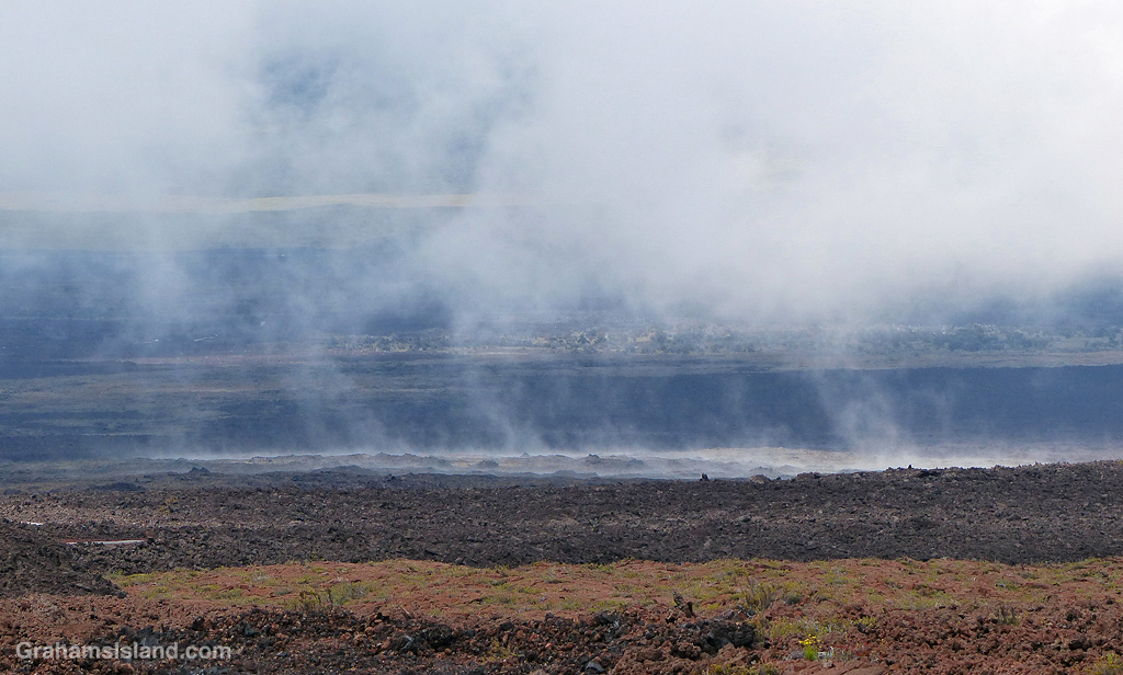
Farther down, the land seemed to be steaming, but in the saddle between Mauna Kea and Mauna Loa, the weather often seems to be part of the landscape.
And the views, which change with every twist in the road, are strange and stunning and wonderful. It may not be possible currently to reach the end of the road, but it’s still a great drive.
The approach to Kona Airport passes over barren lava fields and I often feel for people who must look down from the plane and wonder what the heck happened to the beautiful, tropical Hawaii they were looking forward to visiting. I know I felt that way on my first visit.
I saw these two fishermen on these rocks at the foot of a cliff in North Kohala. By the time I got organized, this is the photo I got. The photo I was after happened moments earlier, when the pair were being soaked by spray from a big set of swells breaking against the rock shelf the right of this photo. By the time the next big swells moved in the two of them had moved farther away from that spot and the photo opportunity had gone.
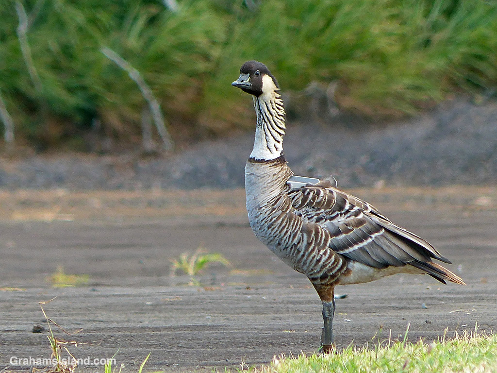
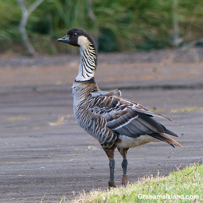
In last week’s Sunday Stills, Terri included a photo of a bald eagle with a transmitter on its back. In the comments, I mentioned that those trackers don’t stay on that long. Cue a few days ago when I saw this nene at Upolu. When I see nenes at Upolu, I report them to a contact at the Department of Land and Natural Resources (DNLR). The DNLR uses sighting information to build a picture of where the nenes are and where they go.
This is 32A, a bird I first saw in January of 2020. Back then, he didn’t have a tracker, but shortly after I saw him, one was attached. The DNLR thought the bird might be flying to and from Maui, but it turns out he wasn’t. Instead, the tracker has shown he mostly flies between Upolu, Hakalau, and Mauna Kea, all on the Big Island. However, the tracker is still on and still working, and I learned that they generally work for 3 to 5 years.
The reason I know this bird is 32A, besides the tracker, is that many nenes have bands on their legs to help with identification. In the second photo, the bands can be seen at grass level. The smaller band, on the left leg, is a US Fish and Wildlife tag. I’ve never been able to see any information on this smaller tag on any of the birds I’ve seen. The tag on the right leg is actually gray and shows the bird is one of almost 600 birds that were moved to the Big Island from a golf course near Kaua’i airport, between 2011 and 2016. These birds more than doubled the population of Big Island birds at that time. The fact that the tag is on the right leg means the bird is a male. The fact that the tag is brown and barely readable shows this bird has been wading through some very muddy conditions!
There are two streams that tumble down the hillside in Hawai’i Tropical Bioreserve & Garden. This one is Alakahi Stream and the section in the photo is known as Boulder Creek Falls for fairly obvious reasons.
For more information about Hawai’i Tropical Bioreserve & Garden, go to htbg.com.