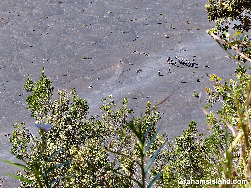
These views of the trail across Kilauea Iki Crater, taken from the rim of the crater, give some idea of the scale of Kilauea Volcano.
Above, a group of people, looking very small, walk the trail across the crater floor.
To the left, smoke and gases from the active vent in Halema’uma’u Crater can be seen. Halema’uma’u Crater is part of the Kilauea Caldera which is much, much bigger than Kilauea Iki Crater. And, yes, that same group is still visible on the trail in this second photo, along with several others hiking the trail.
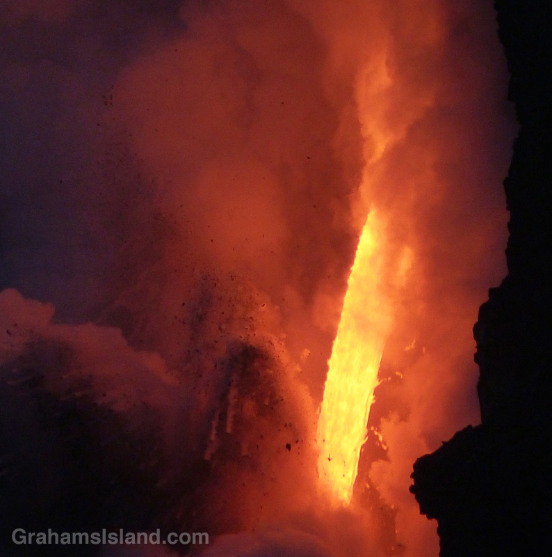
Since the theme of this week’s WordPress photo challenge is elemental, I thought I’d pull out a few more photos from my visit, earlier this year, to the lava flow from Kilauea’s Pu’u O’o vent.
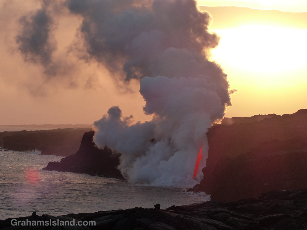
This is the closest we get to seeing fire from the earth’s core, a roaring torrent of molten lava. Since I took these photos there have been cliff collapses that have ended this firehose effect. But the lava continues to flow and has formed a good-sized delta at the foot of the cliff. This delta is crossed by several large cracks, which run parallel to the coast. This means the whole delta is likely to collapse into the ocean in the near future, probably in explosive fashion.
During a recent hike on the Nāpau Trail in Hawaii Volcanoes National Park, one accompaniment was the throb of helicopter engines. The active flow from Pu’u O’o vent, and its ultimate outpouring into the ocean, is a great attraction for visitors and locals alike.
One way of seeing these events is on a helicopter tour and, as I sat at the Nāpau overlook, I noticed there was a clear order to those helicopter visits. A pair would arrive from the west, one a bit behind the other. One would circle the vent, the other visit the ocean entry. Then they’d switch. After 10 or 15 minutes, the two helicopters would head off to the northeast and soon after, the next pair would arrive.
I met Yogi on the trail just before entering the forest. Here, he makes his way through the dense growth.
Huge Hapu’u ferns line the forested section of the Nāpau Trail.
The old Pulu factory.
Yesterday, I posted about the first part of the Nāpau Trail in Hawaii Volcanoes National Park, which crosses extensive lava fields. Today’s post picks up from there, on the rim of Makaopuhi Crater, where the trail slips into dense forest on its way to the Nāpau Crater overlook.
Puʻu ʻŌʻō from the Nāpau Crater overlook.
It’s a remarkable contrast between the stark lava and thriving forest. Birdsong is continuous. Ferns of every kind grow in abundance. Bamboo orchids pop out here and there. And above it all, tall Ohia trees provide the backbone of the forest. This forested trail is clear, but somewhat overgrown. I was hiking in shorts and, at the end of the day, my legs were generously scratched.
Early on in this section, it’s possible to get views of Makaopuhi Crater. Also in this area is the junction with the Nāulu Trail, which starts out at the Kealakomo Overlook, farther down Chain of Craters Road.
The forested part of the trail is about 2.5 miles and towards the end of it is an old Pulu factory. The sign there reads: “Between 1851 and 1884 great quantities of pulu, the soft, reddish-brown fiber covering the coiled fronds of the tree fern (hāpuʻu), were harvested on Hawaii. Much of it was processed within these walls, later to be shipped from Keauhou Landing to foreign markets for use as stuffing in pillows and mattresses.” Unfortunately, in drier climates, pulu quickly breaks down so the industry collapsed.
A little farther along is another junction. To the left is the very basic Nāpau campsite, a few open flat areas and an outhouse. To the right, the trail continues to the overlook, where I was lucky enough to have a wonderful, clear view of Puʻu ʻŌʻō, busily pumping out sulphur dioxide and other gases, and of course, million upon millions of gallons of lava, currently entering the ocean on the southeast coast.
Picking the right day for the hike is not always obvious and weather changes quickly around here. At the visitor center, on the way in, it was completely overcast and drizzling, but by the time I got to the trailhead the sun was out and a nice breeze blew. The wind direction is also important. On this day, the northeast trades were blowing and the vog trailed away to the southwest, which is fine for this hike. But if the wind blows more easterly or south of east, then this trail would be downwind of emissions from the volcano, which could potentially be a dangerous situation.
An early part of the trail follows a surface flow down the side of a hill with a small ohia tree toughing it out in the lava.
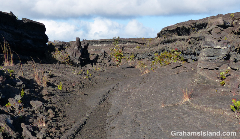
In a couple of places the trail goes through sunken areas that channeled the lava.
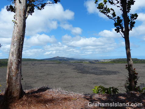
The Nāpau Trail in Hawaii Volcanoes National Park, is a 13-mile round trip. It passes over extensive lava fields, plunges into dense forest, and ends at the Nāpau Crater overlook. The overlook offers a terrific view (weather permitting) of Puʻu ʻŌʻō, one of two active vents on Kilauea Volcano. In today’s post I’m going to cover the lava fields portion of the hike with the second part coming tomorrow.
From the Mauna Ulu parking area, the first mile or so is a well-trodden trail to Pu’u Huluhulu (hairy hill) cinder cone. The foot of Pu’u Huluhulu is where the Nāpau Trail branches off across the lava. It’s a stark landscape, but with lots of interest. The trail passes over surface flows and through channels where lava rivers ran.
The Park’s website notes that the Nāpau Trail “follows the path that magma takes as it makes its way underground from its source at the summit to the point where it comes to the surface near Puʻu ʻŌʻō.” The many steam vents around Mauna Ulu are testament to this.
And in this hostile landscape, nature is at work. The lava fields are dotted with tenacious plants establishing a toehold. Ohia trees and ferns are most frequently seen, but grasses and other plants lend color to this sea of gray and black.
It’s 2.2 miles of unbroken lava from the Pu’u Huluhulu junction to the rim of Makaopuhi Crater, but at that point the trail changes in an almost surreal way. I’ll post that section tomorrow.
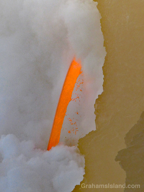
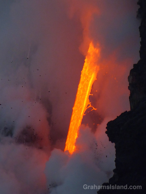
As the sun sinks slowly in the west, a firehose of lava from Kilauea Volcano gushes into the sea. More photos here. A good video of the firehose, since the cliff collapse, can be found here.
I posted here about the current flow from Kilauea Volcano entering the sea, in a dramatic, firehose-like outpouring. In that post, I mentioned that the day after my visit, a cliff collapse caused the firehose to disappear from view. Things have settled down again and the firehose is once more visible, though another large crack not far back from the cliff is expected to cause another collapse soon.
From the Kalapana side, it’s about four miles to the viewing area and a thriving trade in bike rentals has sprung up. When I was down that way last July there were a few bikes available for rent. Now there are maybe 200 or 300 available from a large number of vendors in the parking lot. At the viewing area, bikes were piled alongside the road, and locked in clumps.
I preferred to walk, seeing the towering column of smoke and steam getting gradually larger on the way out, and enjoying a star-studded night sky on my return.
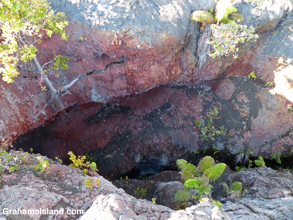
In May of 1969, a series of earthquakes opened a large fissure alongside Chain of Craters Road in Hawaii Volcanoes National Park. This was the beginning of what is known as the Mauna Ulu eruption. For five years, lava poured forth in a series of eruptions. Chain of Craters Road, completed only a few years earlier, was buried for several miles. Landmarks along the road were destroyed or irrevocably altered. A swathe of forest disappeared in flame.
When the eruptions finally ceased, life soon began to reappear on the barren lava landscape. In this photo, vegetation has reclaimed a section of the original 1969 fissure. Roots are anchored in cool, moist cracks in the lava. The tree on the left is particularly striking. Having started out in a crack on a vertical face, it has reached up to the light and is going strong. I like to think it shows how resilient nature can be.