Tag Archives: Kilauea

Lava lake and morning sky

Lava lake and morning sky

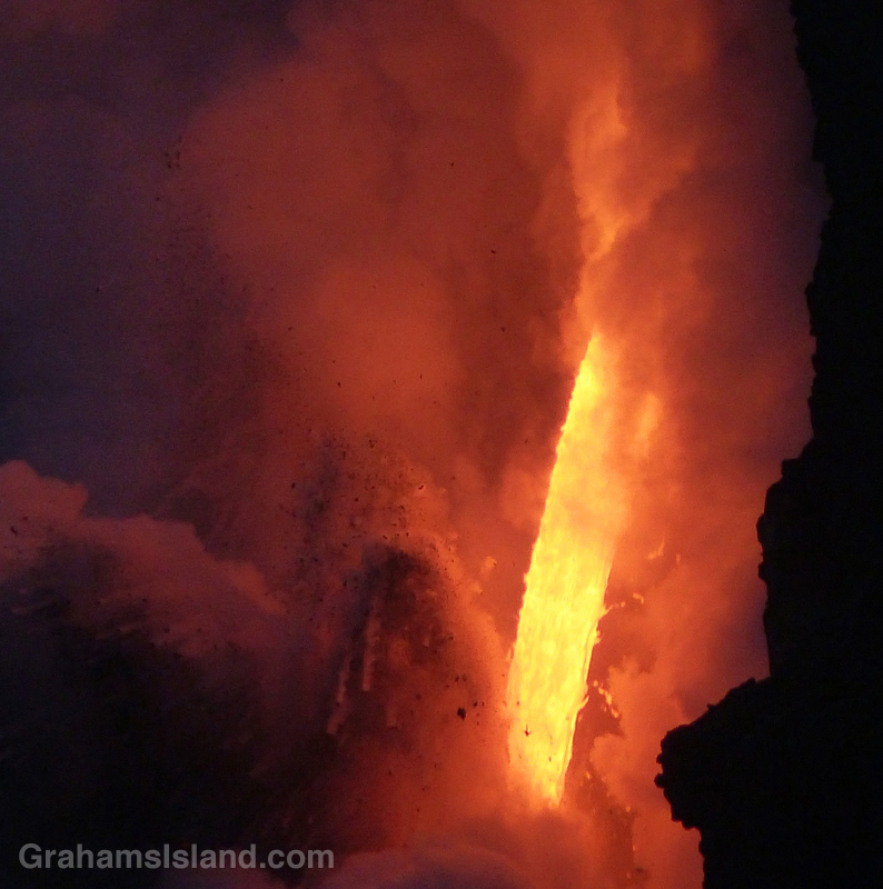
A little over a week ago, I posted photos here of the lava lake at Overlook vent, in Halema’uma’u Crater at the summit of Kilauea Volcano. Here’s a photo of the crater as early morning light illuminated the scene. Around that time the lava was repeatedly spilling out onto the crater floor.

Perhaps you’re wondering if anything has changed in the short time since then. If so, the answer is yes. The lava lake has disappeared, dropping more than 500 feet below the level of the crater floor. Exactly how far its fallen is hard to find out because the people who monitor it have been busy with other things.

On Monday, after a period of increased seismicity, the crater floor of Pu’u O’o vent, the other active vent on Kilauea, collapsed sending a huge ash plume into the sky. When the ash cleared all the lava had disappeared from the vent. This coincided with ominous rumblings and grumblings east of the vent, along the East Rift Zone. Small earthquakes shook the ground. Cracks appeared in paved roads. Lava was believed to be bubbling underground.

On Thursday morning, a magnitude-5.0 earthquake caused another collapse at Pu’u O’o crater. On Thursday afternoon, around 5 p.m., lava erupted in the middle of the Leilani Estates subdivision in the Puna district. A fissure appeared in the ground and molten lava bubbled forth, shooting into the air. This lasted around 2 hours, then ended.

On Friday, yesterday, other fissures opened and poured forth lava, closed again, only for new eruptions to occur elsewhere, but in the same general area. Leilani Estates has been evacuated and is now patrolled by the National Guard. Dangerous sulphur dioxide hangs in the air. Will a full blown eruption occur in that area or will it shut down and appear somewhere else? Nobody knows. People who had to leave their home on 20 minutes notice don’t know when they’ll be able to return or whether there will be anything to return to.

Up here, on the northern tip of the island, there is no danger, though two earthquakes, a magnitude-5.4 around 11:30 a.m. on Friday, and a much more noticeable magnitude-6.9 around 12:30 p.m., were definitely felt. By the time you read this, chances are everything will have changed. That’s the unpredictable, unexpected and often unlikely life, living on an active volcano.

Posted in response to this week’s WordPress Photo Challenge ‘Unlikely.’


Lava lake rising

Kilauea lava wall of flame

Kilauea lava lake lines

Kilauea lava morning

The Overlook vent, in Halema’uma’u Crater at the summit of Kilauea Volcano, has been active since 2008. The level of the lava in the vent goes up and down, mostly 100 feet or so below the crater floor.

Last week, I was looking at the daily activity report and saw that the level was just 30 feet or so below the crater and lava was again visible from Jaggar Museum for the first time since April, 2015. My wife and I had visited during that previous viewing window and thought we’d like to do so again, particularly if the level rose until lava spilled onto the crater floor.

Next day, the level had dropped 40 feet. So much for that. The day after, it was back up 30 feet. We decided to monitor the situation. The lava kept rising, and over the weekend spilled out beyond the vent. Then it went down again. Then it came up again. Etcetera, etcetera.

On Monday, the lava spilled out over the crater floor and we thought about going early Tuesday, but the level dropped and we decided to wait. Tuesday morning, lava was spilling out. We decided to definitely go Wednesday morning (yesterday).

As noted in the previous post here, the issue is that the volcano is about 100 miles from where we live, a two-and-a-half to three-hour drive. Last time we got up at midnight to begin the journey. This time, we gave ourselves an extra hour’s sleep, trading that for breakfast at Ken’s in Hilo at 3 a.m..

So alarms went off, coffee was made, and tiramisu eaten (breakfast of champions), and we hit the road. Happily, the trip over was made under a mostly clear, starlit night and we rumbled into the Jagger Museum parking lot right on schedule at 4:30 a.m.. This time we were better prepared with actual warm clothing. With clear skies and a moderate breeze, it was chilly, especially for Hawaii.

There were already several people there, but not as many as in 2015, so it was easy to find a good viewing spot. Alas, we didn’t get to see lava spilling out because, as I learned later, the volcano had begun a mild deflationary phase (going down) after spilling out in even earlier hours of the morning.

Still, it was worth the journey. For a while, the lava lake was quite active, bubbling away and throwing up spatters in several different areas. One of the things I like about the lava lake, when it’s visible, is that the surface is mostly dark, but it’s cut through by ever-changing lines of bright lava. Sometimes, lava will burst forth from these lines in a frothing hotspot. Other times, a line might disappear as activity moves elsewhere.

These photos show activity along the crater wall (top), a hotspot on the edge of the pool (second photo), morning light seeping in above the volcano (third photo), an active hotspot in the center of the lava lake (bottom).

Posted in response to this week’s WordPress Photo Challenge ‘Lines.’

Kilauea lava lake

Planes landing at Kailua-Kona Airport

Plane landing at Kailua-Kona airport

Hawaii has the reputation of being a tropical paradise, but arriving at Kailua-Kona Airport looks anything but. The final approach to the airport comes over the 1801 Huʻehuʻe lava flow from Hualali volcano. This flow is still quite barren with next to no vegetation. For first-time visitors, touching down on actual tarmac can come as something of a relief.

Exiting the plane, it will most likely be hot, but sunny? Not so much, especially if touchdown is after noon. Typically, clouds roll in during the morning and vog (volcanic smog, caused by pollutants from Kilauea Volcano) settles over the area. The appearance, seen in these photos, is sometimes called ‘concrete skies.’ Not a bad description.

Plane landing at Kailua-Kona

Pu‘u Loa petroglyphs

Not far from the coast, in Hawaii Volcanoes National Park, is Pu‘u Loa petroglyphs trail. It’s only a mile and a half round trip, but visits a place with a huge number of petroglyphs. A raised boardwalk circles part of this area, giving a good view of the petroglyphs without adversely impacting them.

One of the main features of this area and its petroglyph field is explained on a display seen in the second photo. It reads, ‘The name Pu‘uloa (large hill) carries a kaona (hidden meaning)—hill of long life. Families with genealogical ties to these lands come here to place the piko (umbilical cord) of their child. Their hope is that the mana (spiritual guiding energy) of Pu‘uloa would bless that child with a long and prosperous life, and root them to their ancestral lands. Each puka (hole) is created to house a single child’s piko. Of over 23,000 petroglyphs found at Pu‘uloa, 16,000 are piko-related carvings—a testament to the importance of both Pu‘uloa and ‘ohana (family).’

For more information about Pu‘u Loa petroglyphs, go to https://www.nps.gov/havo/learn/historyculture/puuloa.htm.

(On the park’s website, Pu‘u Loa is two words, but on the sign it is one word, hence the inconsistency.)

Kilauea Iki Crater trail

A group of people, looking very small, walk the trail across Kilauea Iki Craterfloor.A group of people, looking very small, walk the trail across Kilauea Iki Craterfloor.

These views of the trail across Kilauea Iki Crater, taken from the rim of the crater, give some idea of the scale of Kilauea Volcano.

Above, a group of people, looking very small, walk the trail across the crater floor.

To the left, smoke and gases from the active vent in Halema’uma’u Crater can be seen. Halema’uma’u Crater is part of the Kilauea Caldera which is much, much bigger than Kilauea Iki Crater. And, yes, that same group is still visible on the trail in this second photo, along with several others hiking the trail.

For more information about Hawaii Volcanoes National Park, go to nps.gov/havo/. For more information about Kilauea Volcano and it’s eruptions, go to hvo.wr.usgs.gov/kilauea/history/main.html.

Fire from the volcano

Lava from Kilauea’s Pu’u O’o vent pours into the ocean.Lava from Kilauea’s Pu’u O’o vent pours into the ocean.Lava from Kilauea’s Pu’u O’o vent pours into the ocean.

Since the theme of this week’s WordPress photo challenge is elemental, I thought I’d pull out a few more photos from my visit, earlier this year, to the lava flow from Kilauea’s Pu’u O’o vent.

This is the closest we get to seeing fire from the earth’s core, a roaring torrent of molten lava. Since I took these photos there have been cliff collapses that have ended this firehose effect. But the lava continues to flow and has formed a good-sized delta at the foot of the cliff. This delta is crossed by several large cracks, which run parallel to the coast. This means the whole delta is likely to collapse into the ocean in the near future, probably in explosive fashion.

Could be time for another visit!

Lava from Kilauea’s Pu’u O’o vent pours into the ocean.Lava from Kilauea’s Pu’u O’o vent pours into the ocean.

Abstracts: A softer, gentler firehose of lava

The firehose of lava entering the sea from Kilauea Volcano
One last photo from my trip to see the firehose of lava from Kilauea Volcano gushing into the sea. I tried a few longer exposures and I particularly like the effect of this one. More lava photos here.

For more information about Kilauea Volcano and it current eruption, go to hvo.wr.usgs.gov/activity/kilaueastatus.php.

Firehose of lava at sunset

As the sun sinks slowly in the west, a firehose of lava from Kilauea Volcano gushes into the sea.
As the sun sinks slowly in the west, a firehose of lava from Kilauea Volcano gushes into the sea. More photos here. A good video of the firehose, since the cliff collapse, can be found here.

For more information about Kilauea Volcano and it current eruption, go to hvo.wr.usgs.gov/activity/kilaueastatus.php.