

A low rainbow seen over a tranquil sea.
Category Archives: Weather
Sun dips below the horizon
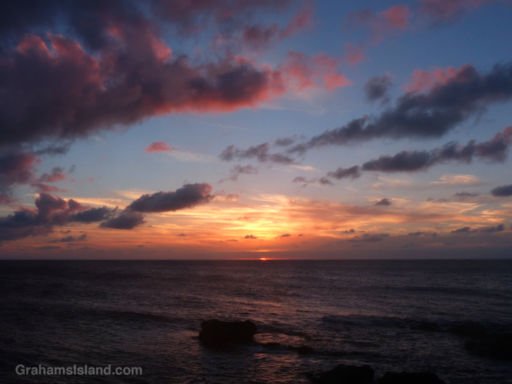
A last glimpse of the sun as it continues on its journey around the Earth, the flat Earth that is. Just trying to get hired as a presidential advisor.
Abstracts: Drying mud puddle
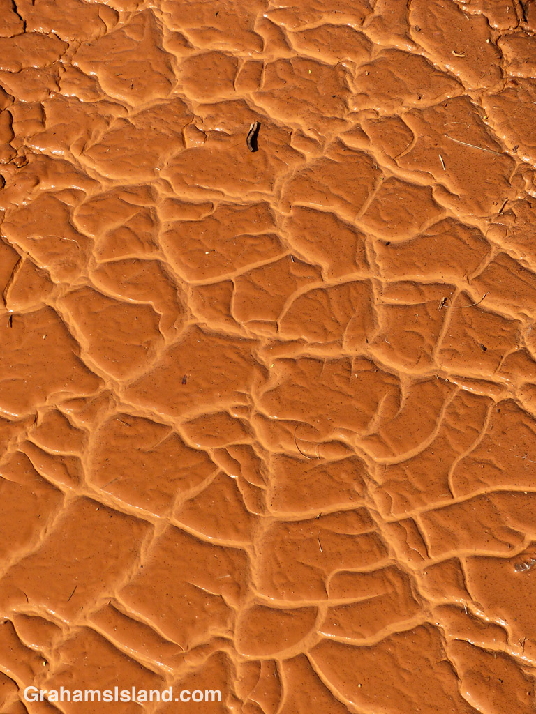
Out on a walk one day, I came across this mud puddle well into the process of drying. I like the soft, pale channels between the segments, which will soon dry into hard cracks. Those cracks and segments will be ground into dust by traffic – until it rains again.
Sun sets behind Kaho’olawe

Kaho’olawe is the smallest of the eight main Hawaiian islands and lies about 7 miles southwest of Maui. After stints as a penal colony and ranching country (resulting in extensive erosion), the island became a Navy bombing range during World War II. It wasn’t until the 1990s that this ended and the island was transferred to the state of Hawaii. Several years of unexploded ordinance removal followed.
Not surprisingly, the island is uninhabited and today it’s managed by a commission with a view to continuing its restoration.
For more information about Kaho’olawe, go to kahoolawe.hawaii.gov/home.php.
Reclaiming the lava

Lava flows make for a stark landscape, but I always find it fascinating to see how, even in such barren ground, nature regains a foothold. Here, a small shrub has taken hold in a crack in the lava. Just below and to the left of it, a fern grows under a ledge.
If there’s enough rainfall, as there is in this spot of the southeast coast of the Big Island, vegetation will begin to take hold in a fairly short while. That’s assuming that a new flow doesn’t happen along and put paid to the process.
Pu’u Wa’a Wa’a hike
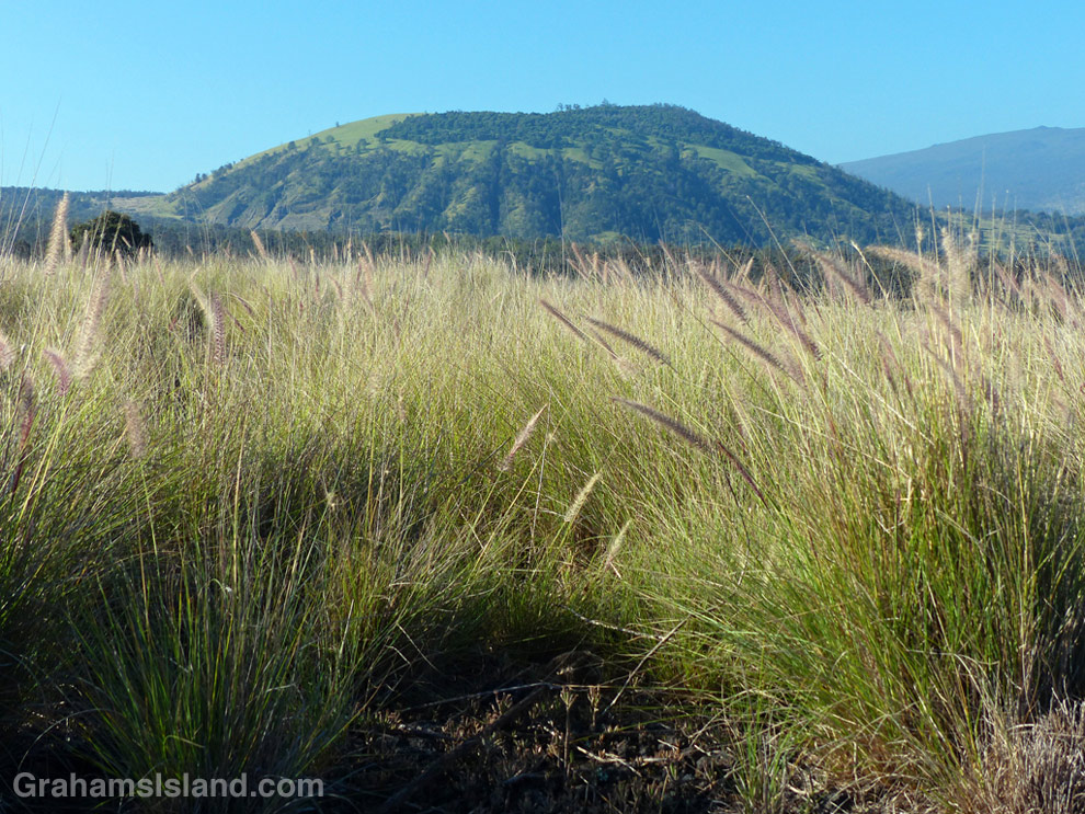
Pu’u Wa’awa’a seen from the trailhead over a sea of fountain grass.

This old quonset hut, at the foot of Pu’u Wa’awa’a, was probably an old ranch building.

Tamaki Corral was used by the old Pu’u Wa’awa’a Ranch. Hualalai is visible in the background, before clouds rolled in.
Pu’u Wa’a Wa’a means “many-furrowed hill.” It’s popularly known as ‘jello mold,’ and is the biggest of several cinder cones on the slopes of Hualalai volcano.
The land is a State Forest Reserve with about 8 miles of hiking trails. The main trail leads to the top of the cone and is about 3 miles each way. The first half follows an old road that passes through a mostly forested area. There’s a good deal of bird life here, more often heard than seen in my experience. The trail then heads up the side of the cone itself in open country, passing old ranch buildings and likely some cattle, horses, sheep and goats.
Once at the top, the views can be tremendous, but an early start is needed. Clouds build up on the slopes during the morning and by midday the view can be fading or gone.
For more information about Pu’u Wa’a Wa’a and its trails, go to puuwaawaa.org.

The smaller Pu’u Iki cone seen from the top.
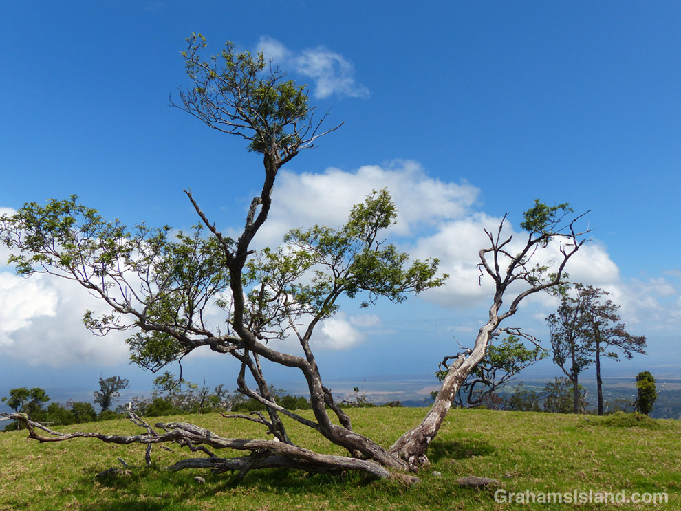
A Mamane tree atop Pu’u Wa’awa’a, with the coast in the distance.
Helicopter in a rainbow
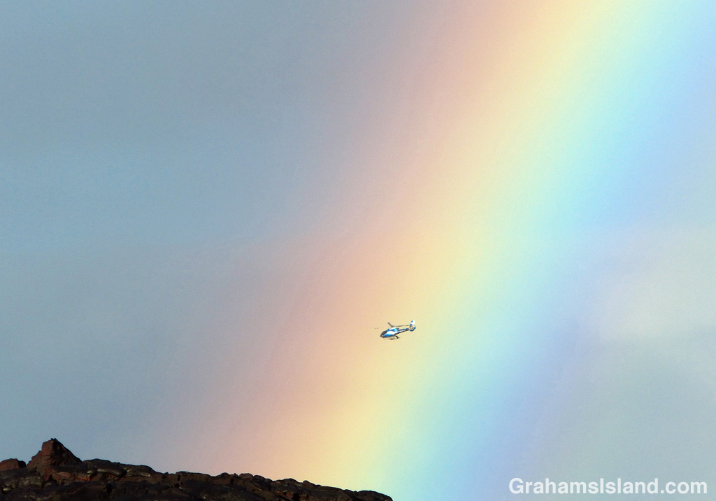
A tour helicopter passes a rainbow on the way to view the active lava flow from Kilauea Volcano’s Pu’u O’o vent.
Hike to Kilauea’s lava flow

The Lava Ocean tour boat edges up to the new bench in the ocean, created by the flow.
This photo was taken within a few seconds of this lava breakout beginning. The couple on the right hadn’t yet noticed it.
The breakout spreads …
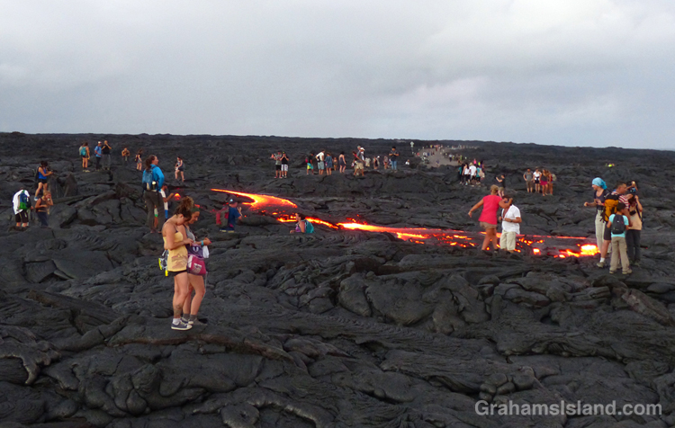
… and extends toward the water. This was about as far as it got while I was there. All these people are standing on the active flow.
Last week, I posted twice (here and here) about a boat trip to see lava entering the ocean from Kilauea Volcano’s Pu’u O’o vent. Since then the ocean entry widened dramatically to more than 700 feet. With all that activity, I thought another hike to the flow was in order. This time, instead of hiking from the viewing area at Kalapana, I decided to go through Hawaii Volcanoes National Park.
The hike starts on the coast, at the end of Chain of Craters Road. It’s about an 8.5 mile round trip, and follows the emergency gravel road constructed in 2014. While the whole area is a stark covering of old lava flows, I liked seeing ferns and the occasional shrub getting a toe hold in cracks and under ledges. And then, with late afternoon light slanting from behind and rain showers approaching from ahead, a brilliant rainbow lit up the sky.
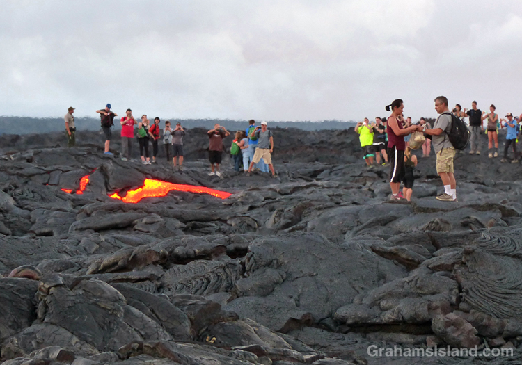
Regarding the current flow, the USGS website notes that “the entire area presents a significant hazard to visitors.” It goes on to list dangers from toxic gasses, explosive events, and unstable ground. So it was with some surprise that when I arrived, I found the flow crawling with people. This wasn’t because it had suddenly stopped and cooled. At the edge, where it crossed the road, the red glow of active lava could be seen. I talked to one of the park rangers keeping an eye on things. He said all they could do was post signs and try and make people understand the dangers. They had roped off some areas and people just stepped over the ropes. It gave me a warm glow to know that, if someone was injured here, that person would understand it was their own fault and wouldn’t turn around and try to sue the park service for millions.
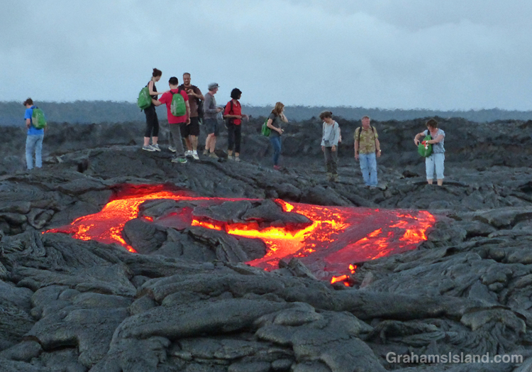
I wandered down the edge of the flow to the cliff where the new bench being formed by the lava could be seen. Then back to the road and I figured, if everyone else is doing it, it must be safe, right? Ha, ha. The thing is, standing next to the flow, the heat was significant, and stepping on to it, it got hotter still. My feet got distinctly toasty, so I took a couple of photos and turned around. A few minutes later, I happened to be looking in the direction of one of the clumps of people standing on a lump of lava. Suddenly, a river a red burst from near the base of the lump. A breakout, and a decent-sized one at that.
Naturally, the people nearest to the breakout quickly moved away from the danger. Ha, just kidding. People rushed toward the lava because, though the surface was obviously unstable and could turn to deadly, molten liquid at any moment, it probably wasn’t going to happen to the lump they stood on. Frankly, it was all a bit surreal.
Later, I saw the ranger I’d talked to earlier doing a brisk trade in fixing the detached soles of shoes – flat tires, he called them – where heat from the flow had melted the glue. As the light dimmed, numerous glowing red patches of lava showed up, speckled with white and yellow flashlights as people meandered through the dark.
It was time to go before someone out there misstepped. I had a three hour drive ahead of me and I didn’t want their screams ringing in my ears.
For more information about Kilauea Volcano and it current eruption, go to hvo.wr.usgs.gov/activity/kilaueastatus.php.
For more information about boat trips to see the lava, go to lavaocean.com.

A rainbow rises over the road to the flow.
