
This dramatic cloud formation drifted menacingly over Kawaihae port one afternoon. Luckily, nothing biblical happened and the port survived.

This dramatic cloud formation drifted menacingly over Kawaihae port one afternoon. Luckily, nothing biblical happened and the port survived.
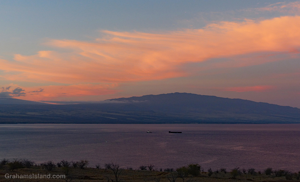
Wispy clouds catch the early morning sun above Hualalai volcano while an inter-island tug and barge heads in toward Kawaihae harbor.
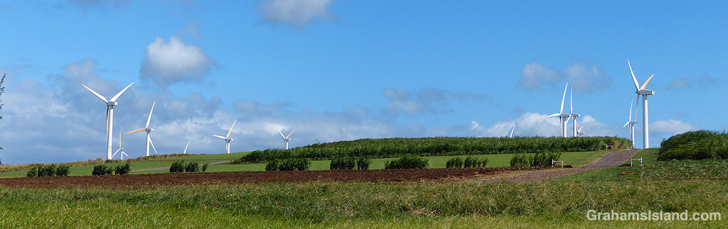

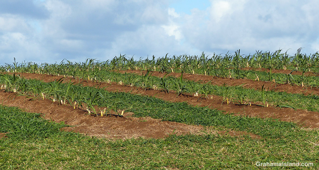
North Kohala was a significant center for Hawaii’s sugar industry through the boom years in the 1800s until its decline in the first half of the 20th century. Now, sugar cane is being put to a new use in the area – rum production.
The photos show sugar cane being grown in the fields below Hawi wind farm. This isn’t just any kind of sugar cane. These are heirloom varieties, derived from canoe plants – plants brought to Hawaii by the original Polynesian settlers. Now they’re being used in the production of rum agricole.
Rum agricole hails from the Caribbean, particularly the island of Martinique. Regular rum is made from molasses, but rum agricole uses fresh sugarcane juice. The people behind Kuleana Rum have begun producing the Caribbean-style rum here on the Big Island. They have a distillery in Kawaihae, about 17 miles down the coast, and have opened Kuleana Rum Shack, a bar and restaurant in Waikoloa.
For more information about Kuleana Rum, go to kuleanarum.com. Posted in response to this week’s Sunday Stills challenge on the theme of ‘Spirit.’ See more offerings here.
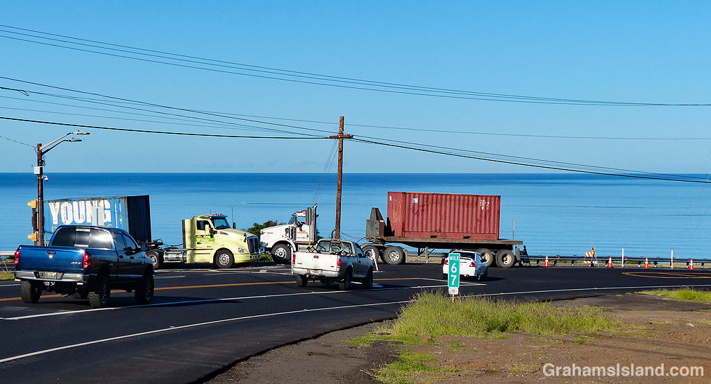

This is the highway intersection about a mile east of Kawaihae. It’s the junction of three roads, Kawaihae Road coming down from Waimea, Akoni Pule Highway from Hawi and North Kohala, and Queen Kaʻahumanu Highway (better known as ‘Queen K’) from Kailua Kona.
It’s always been a problematic junction because Kawaihae Road and Queen K are part of the main loop road around the island, but the right of way at this junction was the Kawaihae Road to North Kohala road. Traffic would get backed up on Queen K, particularly in the afternoon, and accidents were common. Compounding the problem was that the road from Kawaihae carried a lot of trucks coming to or from the port there.
So earlier this year a revision of the intersection was started. A right turn lane was added to Queen K, for traffic going up the hill to Waimea, and a right turn lane was added Akoni Pule Highway for people headed south. (There was already a left turn lane on Kawaihae Road for people going south.)
Don’t worry if this makes no sense, because it makes no sense. What was being set up seemed doomed to failure.
The problem was that the new right turn lane from Kawaihae onto Queen K was fitted with a yield sign. This meant traffic from Waimea, turning left onto Queen K had to give way to traffic heading up the hill, but had the right of way over traffic turning south.
The first accident happened before the intersection was finished. Someone failed to make this right turn and plowed into the guard rail opposite. Shortly after this, two cars collided in the middle of the junction. There were more near misses and accidents.
The yield sign was changed to a stop sign. This helped, but did nothing to stop the confusion of drivers coming down from Waimea. White poles were added to the lane divider for the right turn lane from Kawaihae. Bumps were placed in the other lane for traffic going up the hill. The accidents continued, as did the near misses.
These photos show that right turn lane coned off, as the powers that be have decided to take out the right turn lane. So what we have managed here is several months of work and adjustments has caused a bunch of accidents and near misses and now a good portion of that work is going to be undone and returned to its original unsatisfactory configuration. Your tax dollars at work!
It’s not been a great period for the highway department. A major project saw the main road north of Kailua Kona to the airport widened from two to four lanes. This was delayed for several months because plans given to the road construction company failed to include right turn lanes into Kaloko-Honokohau National Historical Park. The problem here was that it’s national historical park because there are a lot of Hawaiian artifacts in the area, so a new archeological study had to be carried out.
And my personal favorite was the construction of a new highway south from Kailua Kona, intended to relieve traffic congestion in that area. The new highway connected to a previously confusing and dangerous ‘Y’ layout, that became a four-way intersection complete with traffic lights. It was opened with much fanfare and the only issue was that people, tourists and locals alike, had no clue where they were supposed go because there was no signage showing which road went where. Yes, that’s an exaggeration. There was one sign, left over from the previous configuration of the intersection, that now directed people in the wrong direction.
And the moral of this story is that, if you visit the Big Island, please drive with caution.
Posted in response to this week’s Friendly Friday challenge on the theme of ‘Mistakes.’ See more responses here.

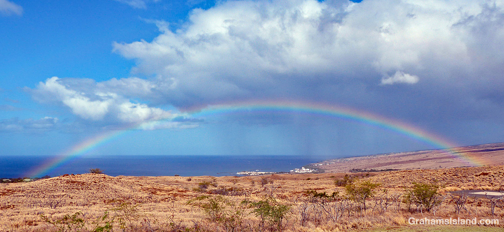
A rainbow stretches out above Kawaihae, the main port on the west side of the Big Island.

The Kohala Divers boat, Namaka, heads out of Kawaihae harbor for an early morning dive session. The boat is also used for whale watching cruises.
For more information about Kohala Divers, go to kohaladivers.com.
After something of a dry spell, during which I was able to drive my truck out of the yard without sliding about, there’s been a lot of rain lately. My truck is back to sliding, but that’s a minor issue compared with what happens to all that rainfall.
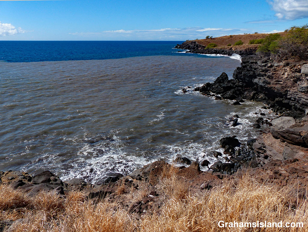
What happens is that the rain hits the land and runs downhill. It channels into dry gullies. If the rain is heavy enough, flash floods occur and wash all before them – dirt, rocks, trees. But any kind of heavy or prolonged rain will wash earth and debris down the gullies. All those gullies lead to the ocean, channeled under roads by culverts (bottom photo).
When the runoff reaches the ocean, it forms a distinct area of dirty brown water in the blue Pacific Ocean (top photo). The contrast is striking and easily visible from miles away. Over time, the brown and blue water will begin to mix until the delineation is gone, but part of that process is the dirt from the brown water settling to the ocean floor.
This kind of runoff is one of many threats to coral reefs around the Big Island. It’s not just dirt in the runoff, but also pesticides and other chemicals that can be washed down into the reefs, damaging the coral. There are hundreds of gullies and only a few places have erosion prevention measures to help mitigate this pollution.
So while Hawaii may be considered paradise, it has its share of challenges. And the problems associated with runoff and pollution are more visible and obvious than most.
Posted in response to this week’s Friendly Friday challenge on the theme of ‘Contrasts.’ See more responses here.

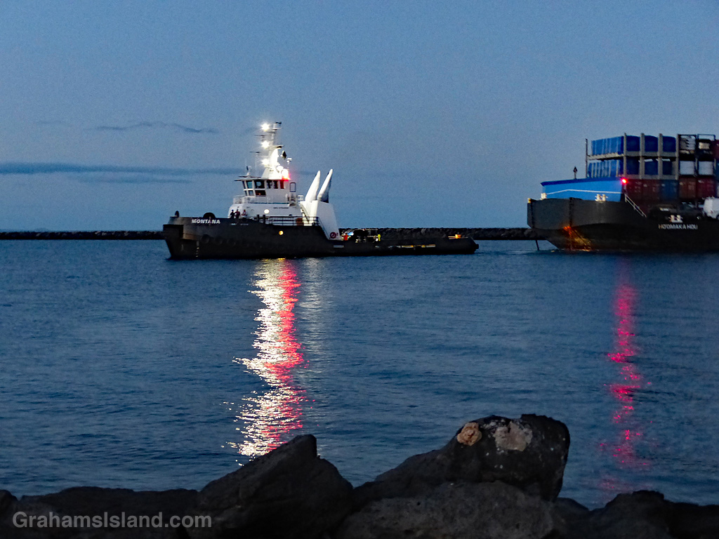
 Once upon a time, I used to know the International Regulations for Preventing Collisions at Sea, also known as the rules of the road for shipping. Like those for automobiles, the rules are designed to keep traffic flowing safely. They govern such things as which vessel has the right of way, what sounds signals they should make, and what lights they should show.
Most of that knowledge has faded from my memory, like a ship into a fog bank, but every so often something brings bits back into view. These photos illustrate one such event.
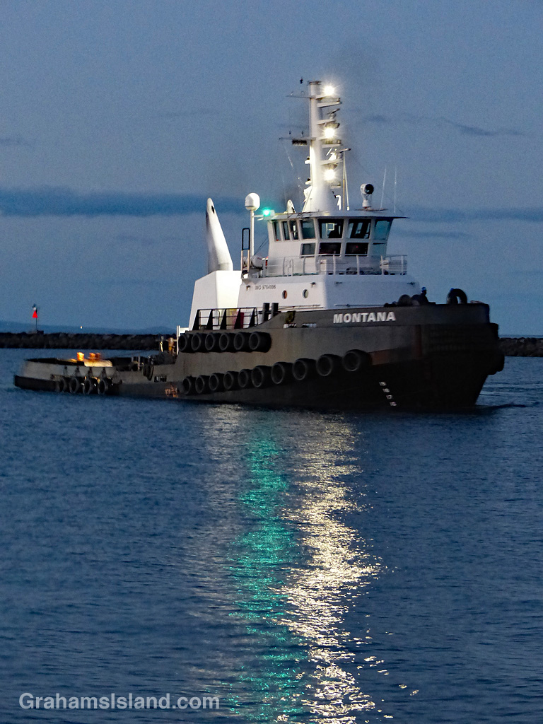
At night, ships and small boats display lights, the idea being that people on other vessels will be able to identify those lights, interpret what they’re looking at, and avoid running into them. In the top photo, the red lights on the tug and barge indicate that’s the port (left) side of the vessel. In the second photo, the green light indicates that’s the starboard (right) side of the vessel. Seeing these lights and how they move in relation to your own position gives a good indication of how close the other vessel will pass. For example, is you can see both the red and green lights, that means the vessels is coming directly towards you and the likelihood of a collision is high. In this case one or both vessels should change course.
As an aside here, I was on the bridge of an oil tanker in the Strait of Malacca, near Singapore, when a ship traveling in the opposite direction suddenly turned 90°, heading directly across our path. This occurred during the day, so the correct action for our ship was to sound the horn for five short blasts, which is the nautical way of expressing ‘What the *&%# are you doing?’ The officer on the bridge duly pounded the horn button to send this message, except that after three short blasts it wheezed into silence (it was an older ship). Three short blasts mean ‘my engines are going astern,’ which was the exact opposite of what was actually going on. About three seconds later, the captain shot through the door and wanted to know why the hell we were going in reverse. We all lived through the experience, but I’m never surprised when ships collide or run aground; there are a lot of factors involved.
Back to the photos and what prompted this post. On the tug’s mast are three white lights. That means it’s a power-driven vessel engaged in towing – it’s a tug after all – but, and I remembered this, the three lights mean the length of the tow is greater than 200 meters. Granted, in the photo, the length of the tow is less than 200 meters, but that’s because they’re arriving in port and the barge has, deliberately, been allowed to ease up close to the tug, prior to maneuvering it alongside the jetty.
Having unburdened myself, I can now slip the lines on that pearl of nautical wisdom and let it drift back out into the gigantic, floating garbage patch that is my memory.
