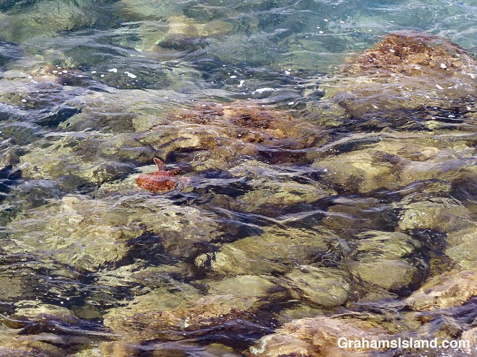
A Hawaiian green turtle swims over a field of large boulders, looking a bit like a boulder itself.

A Hawaiian green turtle swims over a field of large boulders, looking a bit like a boulder itself.
This week’s Sunday Stills challenge theme is ‘On the road’ (more responses here), and I thought of this image.
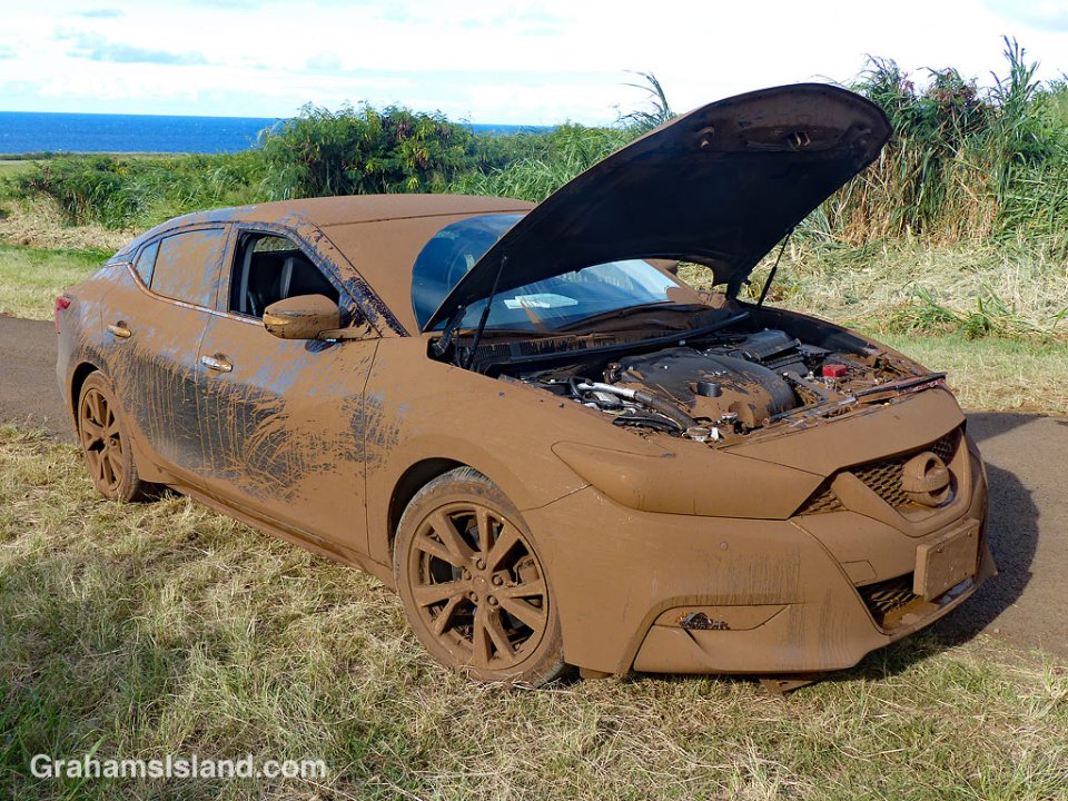
One of my regular walks is a loop around Upolu Airport, at the northern tip of the Big Island. It’s a dirt road and rough in places, but excellent for walking, especially along the coast. There’s a spot where this loop reaches the coast where visitors, en route to Mo’okini Heiau and King Kamehameha’s Birthplace, pause to view the coast and get their bearings.
On this day, I ran into two older men in the car in the photo and they asked me about driving to the heiaus. I said it was possible (I’ve seen a Smart Car out there before), but there were two things to watch out for. The first was clearance. As you can see, their car didn’t have a lot of that and the dirt road is studded with rocks, some of them capable of disemboweling a vehicle. The second thing I mentioned was that the road could have significant mud puddles. I hadn’t been down that way in a while and so didn’t know the state of the large puddles that form when there’s rain. But I said they could drive down past the house and they’d see the first one. I cautioned that if there’s mud I wouldn’t recommend them driving through it. A Jeep would be OK, but not that car. The mud can be quite deep, which is bad enough for a low-clearance car, but that mud can also conceal those disemboweling rocks.
The two men thanked me for the information and drove off. I carried on with my walk.
About 45 minutes later I neared the parking lot and saw their car pulled over on the side of the road. My first thought was that the car looked as if it had been coated with chocolate. The brown layer across the front, top, and back, was perfectly smooth. The sides were more splattered, but it was clear that an impressive amount of mud had somehow been made to coat most of the car.
I had a momentary panic. Had I somehow forgotten to mention the rough road and the mud? Had I said, ‘Don’t worry about the conditions. Just go for it.’ One of the men I’d seen earlier was talking on a phone next to another car. The other was standing besides the muddied car. I walked up to him and before I could say a word he said, “Do you know what the four most satisfying words in the English language are?” I looked blank. “I told you so,” he said. I told him that wasn’t what I was thinking and that was true. I was more curious about what the heck had happened.
He said they’d come to the first mud puddle and his friend, who was driving, said the thing to do was to go through at speed. He’d urged caution, but they zoomed into the mud, disappeared from view, and emerged in a different color car. Oh, and then the car died. They got it going again and somehow coaxed it back to the paved road near where I found them. Quite how they managed this, I don’t know. It meant driving back through the mud and then easing along for another mile to the paved road. They did this very slowly. Once they reached this road, they sped up and the car promptly died again.
I looked into the engine compartment and it was as liberally coated with mud as the exterior. They’d removed the air filter because that was full of mud. Chances were that several other significant engine cavities were similarly choked.
I waited with them until a tow truck arrived and then left. I never learned how bad the car was damaged or how they explained it away. I didn’t really want to know. Instead, I preferred to remember the image of that chocolate-coated car and my image of the magnificent ride that made it that way.
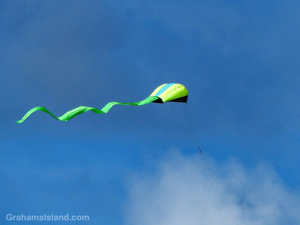
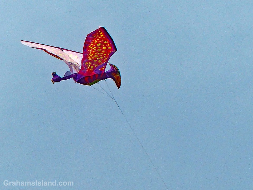
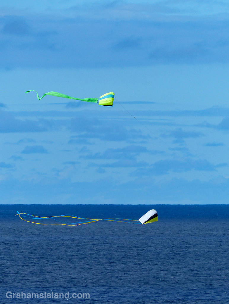 On one of my recent walks, I saw half a dozen kites soaring in the air and I realized it might be the first time I’ve seen kites around here. This is somewhat surprising since North Kohala is notoriously windy and seems like it would be a mecca for kite flying.
Kites are no longer simple diamond shapes on a wooden cross and these were by no means the most exotic kites available these days. But I did like the pterodactyl below and the others were also striking, particularly when they caught the sunlight.
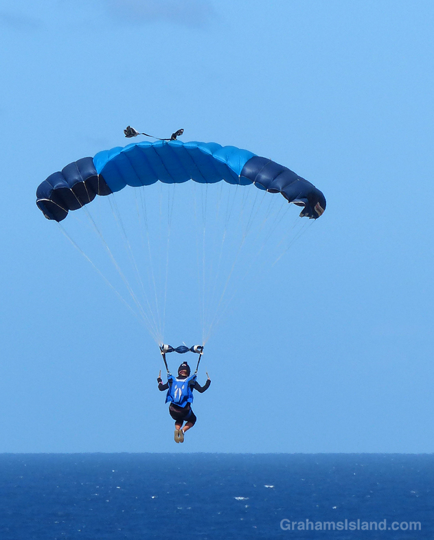
A skydiver heading for a watery landing? It’s all a matter of perspective. Actually, she’s about to take a right and curl down safely to a grass landing at Upolu Airport.

This week’s Sunday Stills challenge theme is ‘Photo-editor.’ See more responses here.
A few weeks ago I posted a composite photo of a rainbow here, which would have been a good choice for this challenge. But I also had more recent photos, of a waterfall in the Kohala Mountains, that I wanted to combine.
I couldn’t capture the full drop of this waterfall, probably somewhere between 500 and 1,000 feet, in one image, so I took two photos. This presented a couple of challenges. First was to combine the image of the top of the falls with the one of the bottom of the falls. The second challenge involved dealing with the horizontal offset of these two photos. Since I was in a helicopter at the time, we’d moved forward between shooting the images.
I’m pretty happy with the final image, especially the capture of the mini rainbow at the base of the falls. Anyway, feel free to see if you can spot where the two photos are connected.
Thanks to Sunshine Helicopters for the tour.
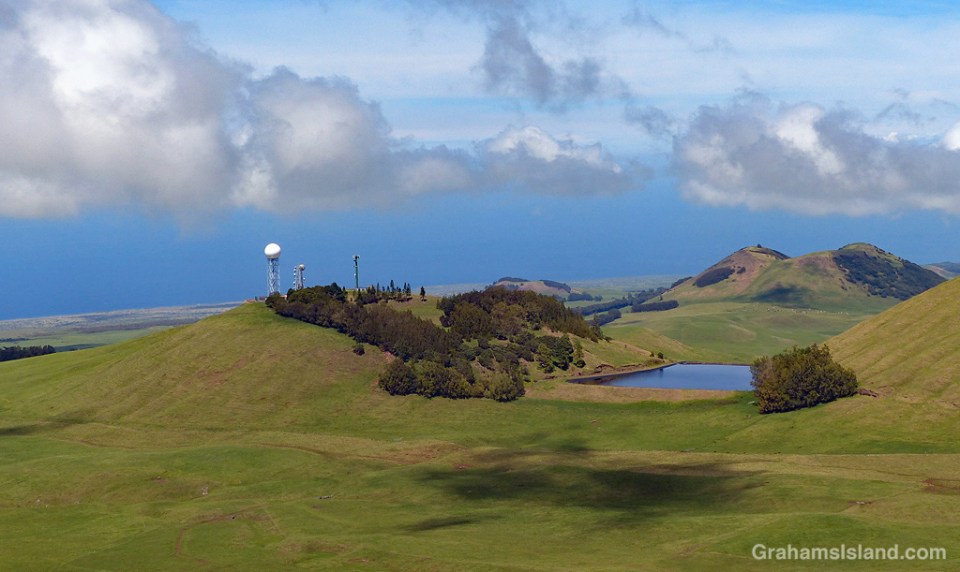
NEXRAD is the Next Generation Weather Radar operated by the National Weather Service, Air Force Weather Agency, and Federal Aviation Administration. There are 160 sites, most of which are spread across the United States. Four of the sites are in Hawaii, two of which are on the Big Island. This site is on Kohala Mountain, northwest of the summit. It’s known to local pilots as the golfball, for obvious reasons.
This weather radar network is a staple of online news and weather sites and shows the location and movement of rain and clouds. The Kohala radar features a pie-slice area of permanently clear weather to the northeast, which I assume is caused by the nearby topography.
I use the weather radar quite a bit and find it fairly helpful, though the weather here is quick to change. Weather forecasts, on the other hand, I find are more of a 50-50 proposition – they’re either fairly right (not too hard to figure out when the trades are blowing) or wildly wrong (all other situations). However, since it’s almost always warm here, I can’t complain too much.
For more information about NEXRAD radar, go to https://www.ncdc.noaa.gov/data-access/radar-data/nexrad.

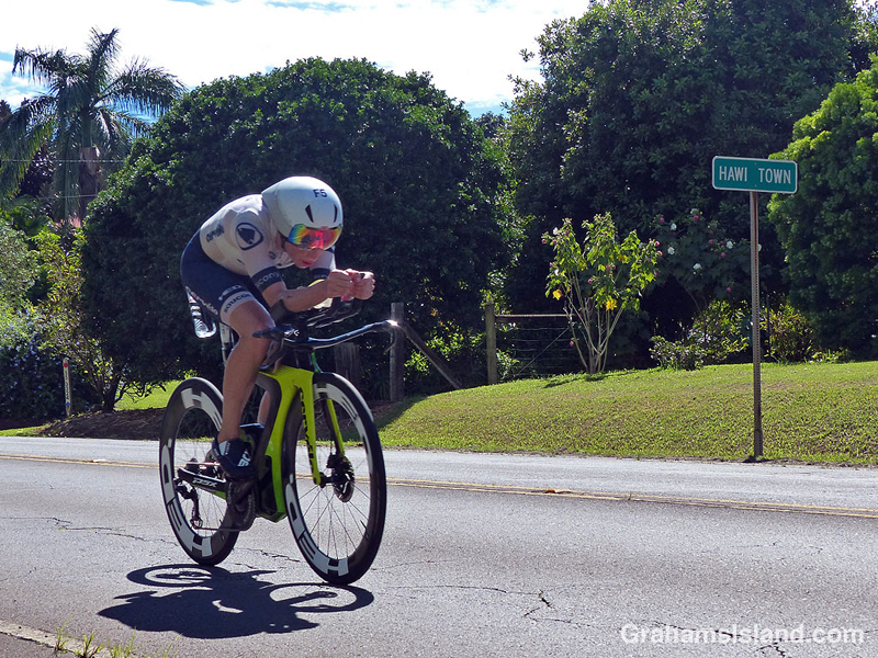


Saturday saw the running of the 40th edition of the Ironman World Championships in Kailua Kona. This is the event featuring a swim of 2.4 miles, a bike ride of 112 miles, and a run of 26.2 miles. As in previous years, I participated in this event by walking out to the main road and taking photos, whenever possible from a nice shady spot.
Actually, this year’s race was run in prime conditions for the athletes. It was overcast with occasional light rain and only a gentle breeze from time to time. Consequently many records were set, including new course records for both men and women.
The top photo shows men’s winner and defending champion, Patrick Lange of Germany, zipping by on his way back towards Kona. Second photo, Great Britain’s Susie Cheetham heads out of Hawi. Third photo, Dan Plews of NewZealand (1685) leads Robin Schneider of Germany (2310), and Neil Eddy of Great Britain (2070). These three finished the bike leg in fairly close proximity, but after the marathon run, Plews finished 21 minutes ahead of Eddy and 45 minutes ahead of Schneider. Fourth photo, Jodie Robertson of the U.S.A demonstrates the importance of color coordination while cycling. Bottom, a large group of riders roll into Hawi, the turnaround point of the bike leg.
For more information about Ironman, go to Ironman.com.

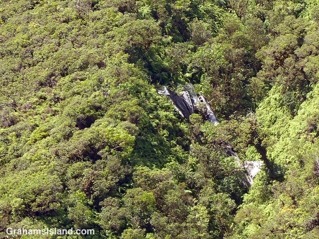
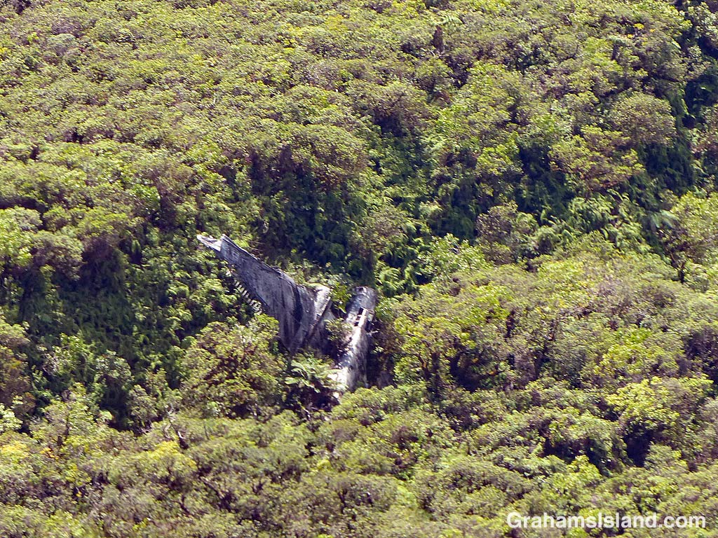
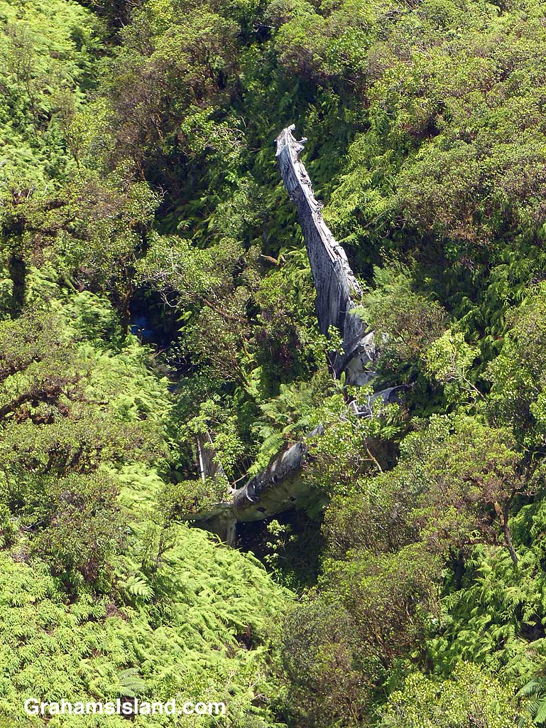 On the evening of Tuesday, February 25, 1941 this twin-engined B-18 bomber was part of a group of four aircraft on a night training mission. They had started out from Hickam Field on Oahu. Not far from Hilo the plane lost its port engine when a bearing failed. The pilot decided to try and reach Suiter Field (now known as Upolu Airport) at the island’s northern tip. It was not to be. Flying on only one engine, the plane lost altitude. The crew thought they were over the sea, but suddenly a mountain appeared in front of them. The pilot yanked on the flight yoke wheel and the plane stalled and flopped into the trees around 10 p.m.. Incredibly only one crewman was slightly injured.
Search aircraft from Hickam Field found the plane the next morning around 9 a.m.. The nose of the plane was hanging over a 75-foot deep ravine about 3,500 feet up on the northern side of Kohala Mountain. It was one of the most inaccessible places on the island. A rescue operation was started, but it was Thursday noon before it reached the crew.
Over the years, the aircraft has slid into the ravine which is where it rests today. As these photos show, the plane’s condition has deteriorated and it is increasingly being engulfed by trees. But it is still quite easily spotted from the air. On the ground, it remains one of the most inaccessible spots on the island.
It’s also worth noting that just nine months after this crash, almost all the B-18 bombers based at Hickam Field were destroyed on the ground during the attack on Pearl Harbor. 77 years on, this B-18, in its remote resting place, is one of only a handful remaining in existence.
For more information about this aircraft and the crash, search online for Big Island Bomber – hiavps.com or go to pacificwrecks.com/aircraft/b-18/36-446.html.