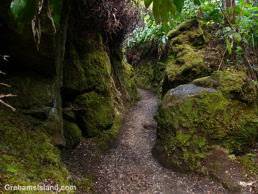
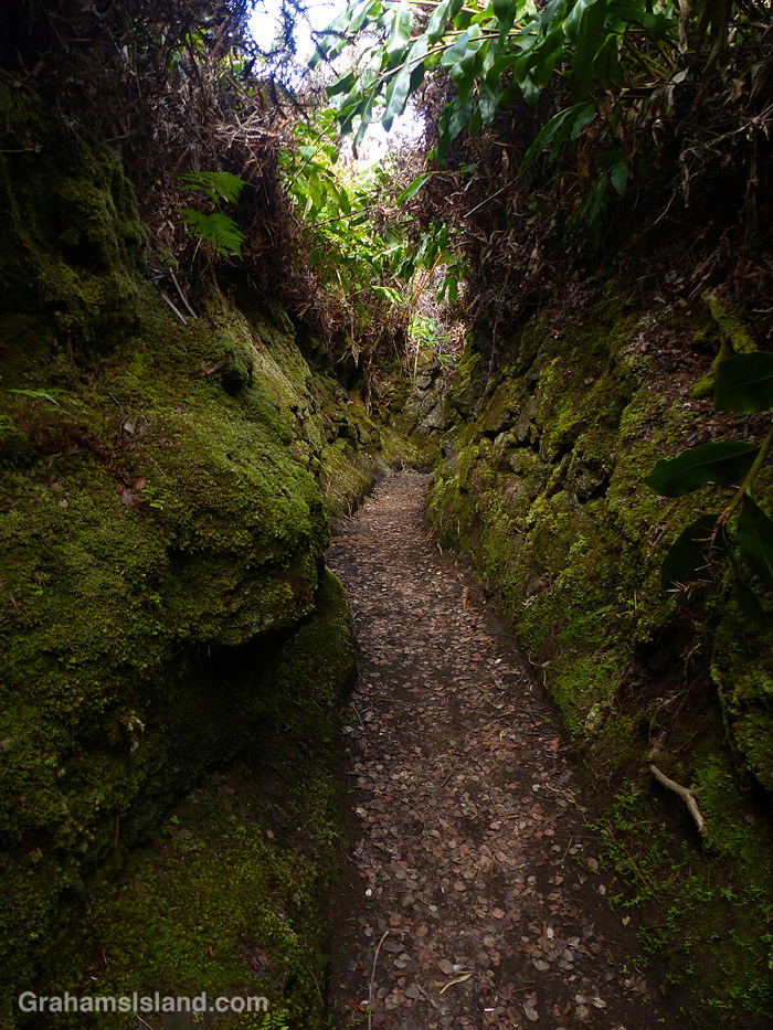
The Halemaumau Trail in Hawaii Volcanoes National Park takes hikers from near the visitor center down to the floor of the summit crater of Kilauea Volcano. It mostly passes through trees and some lush tropical foliage, this being the wet side of the island. Part of the way down the trail eases through a channel between two walls of rock, which are covered in moss. It’s a quite beautiful passage and, in this harsh volcanic area, has a remarkably soft feeling to it.
For more information about Hawaii Volcanoes National Park, go to nps.gov/havo/.
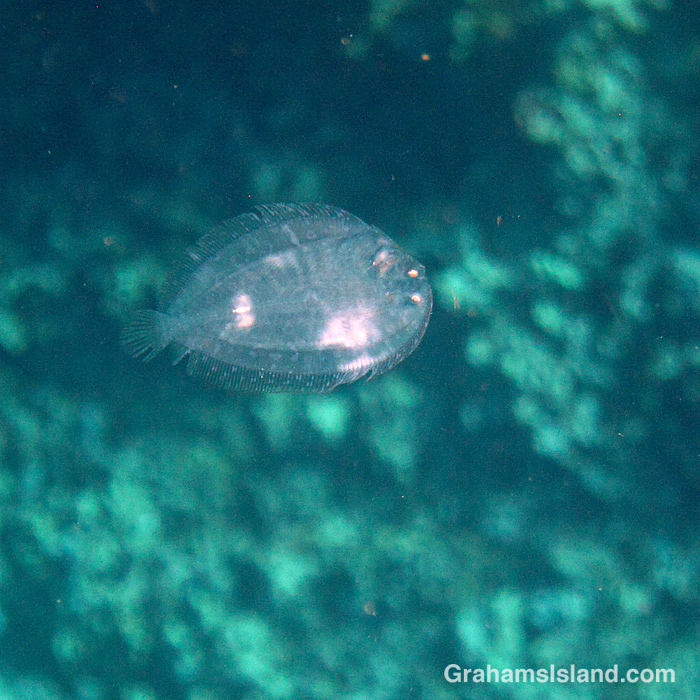
One day, while I was in the water, I ran into a couple of snorkelers who were watching this creature. It was high up in fairly deep water in the middle of the bay. It looked almost translucent and very small, only 2 or 3 inches long. It wasn’t even clear whether this was a live creature or just a bit of floating debris. They took photos, I took photos, but I wasn’t optimistic on how they’d turn out because it’s hard to get the focus right on something like this.
After they left, I hung around and saw the creature swimming, coming up in the water. I took a couple more photos before it descended again. When I got home I was thrilled that, out of the photos I took, this one turned out pretty well. From it, I could see that this was a very small flowery flounder. The general shape and details are a very small version of the adult fish. What’s interesting about this is that flounders start out life looking like regular fish, swimming upright and with an eye on each side of its head. But within a few days, flounders start to lean to one side and one eye begins to migrate to join its partner on the other side.
This tiny, very young flounder has already completed that transition.
There’s a good variety of fish at Two Step including raccoon butterflyfishes, seen here mingling with goatfishes and yellow tangs.
A barred filefish swims by with a startled look on its face, which is just their usual look.
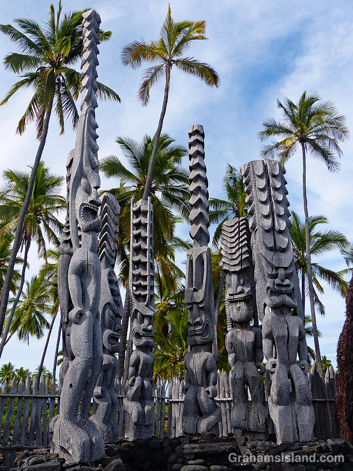
Ki’i at Pu’uhonua o Hōnaunau National Historical Park, better known as Place of Refuge.
This week’s Friendly Friday challenge theme is ‘Anniversaries.’ See more responses here.
Often, on our wedding anniversary, my wife and I go to Hawaii Tropical Bioreserve and Garden (formerly Hawaii Tropical Botanical Garden). This year the garden was shut, and still is, probably until tourists return to the islands. So a different anniversary is my birthday, which is not marked with candles on a cake, since that would be prohibitively expensive, but usually by a trip somewhere and a meal out. This year we went down to snorkel at Two Step and then had a wander around Pu’uhonua o Hōnaunau National Historical Park, otherwise known as Place of Refuge, which is right next door.
Two Step is a very popular snorkeling spot on Honaunau Bay, south of Captain Cook. This is a marine reserve so no fishing is allowed and the fish tend to be more numerous and mellow because of this. It’s a popular spot to see and swim with dolphins, though I haven’t done either of those things there. Currently, it’s not nearly as busy since there are very few tourists on the island and those that are here are diligently following quarantine rules (I’m trying to keep a straight face writing this!).
After our swim we made the short walk to Pu’uhonua o Hōnaunau National Historical Park. The park is on the south side of the bay and, at the moment, is fully open only on Fridays, Saturdays, and Sundays. However, on the other days, pretty much everything else is accessible, it’s just that the parking lot and visitor center are closed. What this means is that there’s basically nobody there so our visit was quiet and uncrowded. The park is an important place in Hawaiian history, and the location is beautiful. What’s not to like?
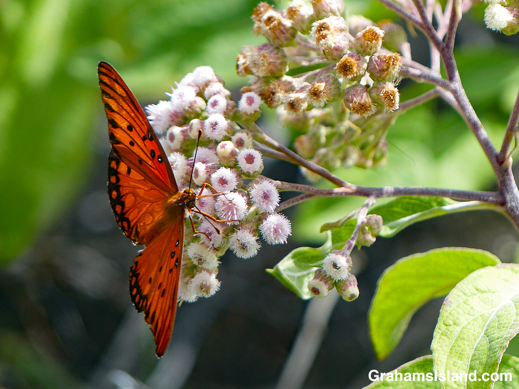
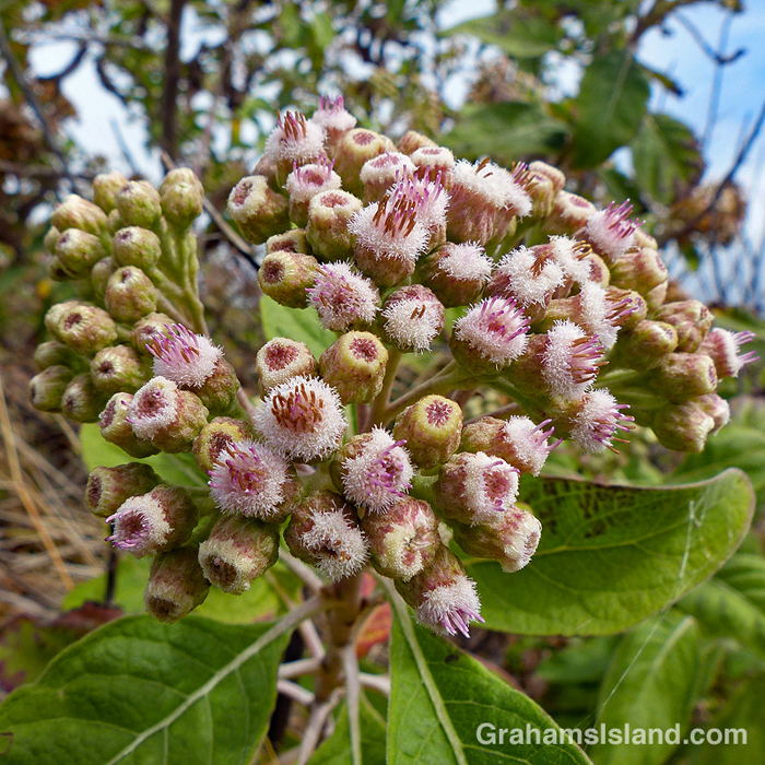
Pluchea carolinensis is also known as sourbush and cure-for-all. This latter name probably comes from its medicinal use in its native range, which is the tropical Americas. It’s a member of the aster family – Asteraceae.
The plant was first reported in Hawaii in 1931 and on the Big Island in 1933. It’s believed to be an accidental introduction, possibly associated with shipping to Hawaii and within the islands. The onset of World War II prompted the plant’s spread through the Pacific, probably in military shipments.
On the Big Island it’s most often seen in drier coastal areas, but it can tolerate a variety of climates and conditions. These photos were taken on the Puna Coast Trail in Hawaii Volcanoes National Park.
For more information about Hawaii Volcanoes National Park, go to nps.gov/havo/.
I’ve posted photos of shoals of little fish before, making the assumption that these were juveniles of some fish species or other. However, this year the local snorkeling spot has been thick with these fish. It’s not been unusual for me to get in the water and find myself surrounded by a swirling ball of fish. It can actually be quite disorienting.
Because of this bumper crop, it occurred to me that I really should try to identify these fish. I think the answer is that they’re Hawaiian silversides, an endemic species. The problem is that there are a couple of other possible species, the goldspot sardine and the Hawaiian anchovy. Short of catching a few and examining them in the light of day, it’s hard to tell them apart.
Regardless of species, it’s been fun interacting with the shoals. Swim toward them and the shoal will part, then recombine behind. Point a camera in their direction and they jet off in another direction. It’s best just to float in the water, with the camera pointed in the right general direction. Then they’ll get quite close and I’ll snap a photo or two hoping something will turn out.
In the top photo, a shoal surges by in front of me. Below, the silvery stripe along their bodies can be seen.
A rainbow arcs over a small red and white flag floating in the water. This flag is used in North America to indicate that there’s a diver or divers below and that boats should stay clear.
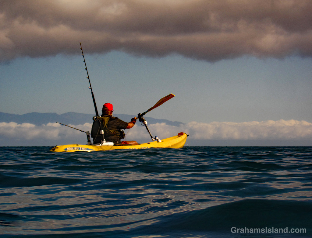
This week’s Friendly Friday challenge theme is ‘Color Harmonies.’ See more responses here.
I like the colors in this photo of a kayak fisherman, with his red hat and yellow kayak. He has a fairly typical setup, with two or three rods attached in one way or another. He’ll have some bait in the kayak and probably a few beverages and snacks.
I was surprised to see him passing so close, but figured that he’d seen me and was being careful. In the end, I was glad I stopped to take this photo because just after I started swimming again, a large lure and hook passed in front of me on his unseen trailing line. Had I not stopped I’d probably have been hooked, reeled in, gutted, and barbecued. Not a bad way to go, really, I guess.
I hope this photo doesn’t ruin anyone’s breakfast, but I run it for a couple of reasons. First, a lot of people fish around the island and most of them don’t like eels. Snag an eel on your line and there’s not much to be done. The eel will wrap itself in knots and the only way to be rid of it is to cut the line. The person fishing could try removing the hook and releasing the eel, but even if they were so inclined, the feeling is, ‘why release an eel so that it can tie itself in knots next time you throw a line in?’
And that brings us to the other reason for running the photo, and which also explains another reason no one wants to remove that hook. Look at those teeth! Rows of them, front and back, side to side. Reach for that hook and chances are you’re going to get bitten. This is also why it’s not a good idea to mess with anything in the water. Even little fish that look harmless can have a powerful bite, or sharp spines, or some other nasty surprise.