Category Archives: Parks

Puna Coast Trail: Along the coast

This is the second part of a three-part description of a hike along the Puna Coast Trail in Hawaii Volcanoes National Park (See part 1 here).

As the trail reaches the coast, it passes over an older flow that has a fair amount of vegetation on it. The third photo shows the trail cutting through a swathe of naupaka, sourbush, and assorted grasses.

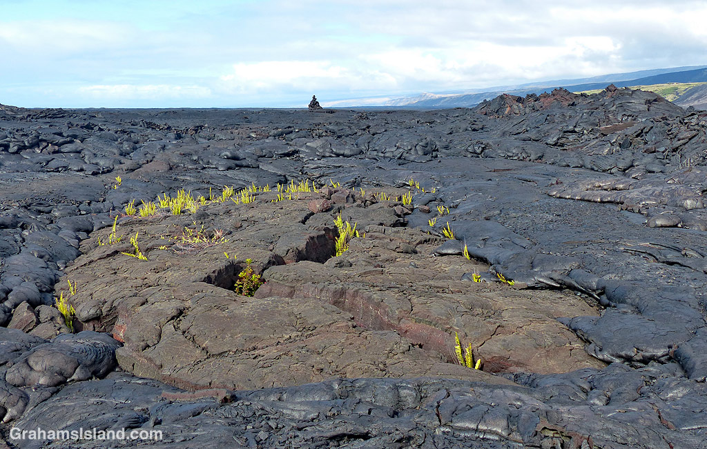
This area was, despite the threat of volcanic activity, well occupied by early Hawaiian people. Along the trail are several reminders of that including the structures below. The photo, below middle, shows the amazing abilities of plants to grow in even the most daunting locations. The roots are somewhere deep in the lava, from which the trunk of this noni snakes upward. The large, nobbly fruit can be seen on this plant. This fruit, when ripe, has a pungent aroma which supposedly smells like vomit!

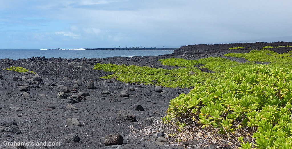
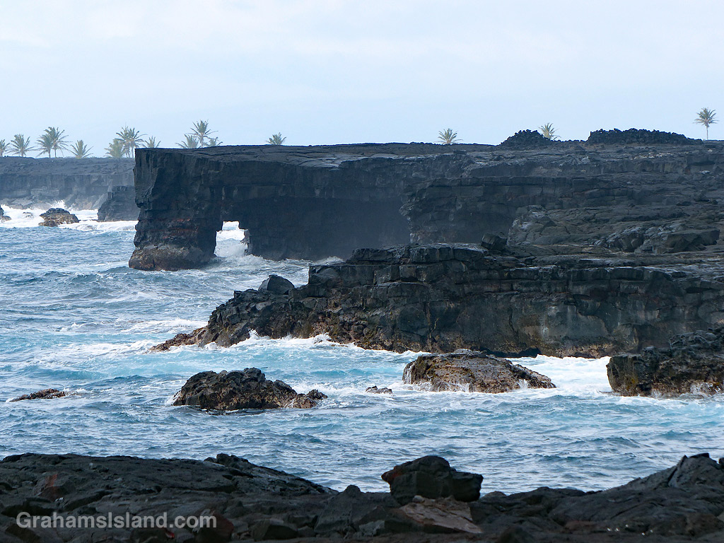
The bottom photo shows an area of rocks and black sand on the coast, backed by an extensive field of naupaka. Beyond that, the trail passes close to a pair of sea arches seen in the top photo and the one at top right. This is a rugged coastline and, when the weather is rough, huge waves can crash up and over the lava. It’s also an unstable coast with rocks and sections of cliff liable to tumble into the ocean.

In the background of the top and bottom photos are the palm trees of ʻĀpua Point, which will be the focus of the third and final post about this trail, tomorrow.

For more information about Hawaii Volcanoes National Park, go to nps.gov/havo/. For more information about the Puna Coast Trail, go to bigislandhikes.com/puna-coast-trail.

Puna Coast Trail: From the trailhead toward the coast

Last month, I posted photos of colorful lava (here) that I saw on a hike I’d just done. In that post, I noted that ‘I’ll do a post about the trail once I’ve gone through the way-too-many photos I took that day!’ With all that’s been going on in the interim, processing those photos took a long time, but now I’m done. So here’s the first of three posts about the trail, not that you can follow in my footsteps right now because Hawaii Volcanoes National Park is currently closed.

As the name indicates, the Puna Coast Trail travels along the coast of the park, but it starts about a mile inland, across Chain of Craters Road from the Pu’u Loa Petroglyphs trailhead. The trail is 11.3 miles long and ends at Halapē campground, but I only hiked as far as ʻĀpua Point, 6.6 miles along the trail. This rugged trail can be hot, windy, and wet so sturdy shoes or boots, a hat, sunscreen, and raingear are a must. There’s no fresh water on the trail so take plenty, as well as enough to eat.

The trail starts by crossing the 1972 flow from an eruption at Mana Ulu. In the top photo, lava from this flow surrounds a small area of older lava. The ferns growing in the cracks are Polypodium pellucidum, an endemic fern known in Hawaii as ae (pronounced Ah Ay). These ferns are among the first plants to grow in new lava fields. The faint outline of the trail can be seen extending from the middle left of the photo to the cairn on the horizon.

Second photo: An upwelling in an old lava flow has cracked open to reveal a variety of colors within. In the background is Hōlei Pali. A pali is a steep slope or cliff. When a flow goes over a pali, it can often be seen, safely, from a distance away.

Third photo: A trail-marking cairn on a section of older lava that has been somewhat revegetated. The noni (Morinda citrifolia) shrub beside the cairn is another early colonizer of lava flows being tolerant of the harsh conditions found there. Noni is a ‘canoe plant,’ having been introduced to Hawaii by the first Polynesians who arrived in their ocean going canoes.

Fourth photo: Cairns mark the trail across the expanse of lava from the 1971 flow, where very little vegetation can be found. This first part of the trail angles down toward the ocean, which can be seen in the distance.

Below: Colorful smooth pahoehoe lava lies on top of ropey pahoehoe lava, from the same 1971 flow. The kind of lava can change quite quickly as conditions change in the flow itself and the terrain it travels through. This also shows the colors in different layers of lava as well as an ae fern getting a toehold.

Bottom: A little hill of pahoehoe lava showing its different forms all jumbled up. I almost included this photo in the earlier post since its colors, textures, and swirls were unexpected art for me.

Tomorrow, part two follows the hike along the coast itself.

For more information about Hawaii Volcanoes National Park, go to nps.gov/havo/. For more information about the Puna Coast Trail, go to bigislandhikes.com/puna-coast-trail.

Colorful pahoehoe lava

This week’s Friendly Friday challenge theme is ‘Art Unexpected.’ See more responses here.

This was a timely topic since, a couple of days ago, I went for a hike in Hawaii Volcanoes National Park. I headed out on the Puna Coast Trail, one of several longer trails west of Chain of Craters Road, that I haven’t explored before. (I’ll do a post about the trail once I’ve gone through the way-too-many photos I took that day!)

One of the highlights of the trail was the extensive areas of colorful pahoehoe lava. I’ve lived here a while now and I know lava doesn’t just come in basic black. I’ve seen lighter and darker flows; I’ve seen flows with a brown tint; I’ve seen flows with hints of red or green in them. But prior to this hike, I had never seen flows with such a variety of vibrant colors.

Instant Hawaii has a description of different types of lava (here) and they say “All the differences in pahoehoe flows stems completely from the temperature of the lava as well as chemical composition. Since both can change during a flow – it is possible to get all types of pahoehoe flowing from a single flow, over time.” I would also say that, what they call ‘quiet flow’ lava, is an apt description of these areas. When I was walking over them I thought they seemed harder and more metallic than the surrounding black pahoehoe lava, which tends to crunch a bit when walked on.

But the other thing I thought, as I found myself continually stopping, stooping, snapping photos, was that these flows were art, Madame Pele’s art, and that wasn’t something I was expecting when I set out on the hike.

For more information about Hawaii Volcanoes National Park, go to nps.gov/havo/.

C-17 plane over Kohanaiki Park

Kohanaiki Park, just north of Kailua Kona, is a popular park which provides a great view of the sunsets, has a good surf break, has protected pools for keiki to paddle in, and has all the facilities needed for a good barbecue.

If there’s a downside to the park, it’s that it’s just south of the airport. It’s not O’Hare, but planes come and go with some regularity. It’s also used by the military and planes, such as this big C-17 transport, practice touch-and-goes with some frequency. So it’s not the most relaxing beach on the island, that’s for sure, but with white sand, blue water, and hot sunshine, it has a lot going for it.

Shadow makers

This week’s Sunday Stills challenge theme is ‘Shadows.’ See more offerings here.

The top photo is a row of colorful playground swings at Kamehameha Park in Kapaau. Below are three cyclists in line, heading out of Hawi during an Ironman World Championship race.

Also posted as a second offering for this week’s Friendly Friday challenge theme of ‘All in a Row.’ (See more responses here.) My first post for this theme is here.

Hawaiian star compass

Kohanaiki Beach Park, north of Kailua Kona, is a favorite spot for surfers. But at the south end of the park, the focus switches to history.

There’s a hālau, Ka Hale Waʽa, which is used for teaching Hawaiian crafts and culture. There’s a garden which grows the same kind of plants brought over by the first Polynesian settlers. And there’s a Hawaiian star compass, a 17-foot diameter recreation showing how the Polynesians used to navigate the vast open spaces of the Pacific Ocean.

The top photo show shows the compass. The middle photo shows a plaque, which explains the basics of how it works, using the points of the compass, the sun, nighttime celestial bodies and the ocean swells. I won’t go into detail here, but more information can be found here, here, and here. Below, the setting of the compass, with a Pacific golden plover walking on it. I like this shot because the plover is said to be the reason Polynesians discovered Hawaii. Each year, plovers summer in Alaska and then fly south as far as New Zealand. It is said that the Polynesians noted this small bird’s annual journey back and forth and figured there must be land somewhere to the north, so they set out in their canoes to find it.

Posted in response to this week’s Sunday Stills challenge on the theme of ‘Round.’ See more offerings here.

Signs: Practice makes perfect

I was hiking in Kalopa Native Forest State Park when I came across the trail sign above. Nothing too remarkable about that, but I happened to notice the back side of the sign (middle), which showed that getting the sign right took a bit of practice.

On a subsequent visit, I noticed that the back of sign at the other end of the trail (bottom) had also seen a rejected first effort.

Kekaha Kai Park beach

This week’s Friendly Friday challenge theme is ‘Future.’ (See more responses here.) Since this is Snow’s last time hosting the Friendly Friday challenge I thought I’d offer a personal interpretation of the theme.

Here is one of the beaches at Kekaha Kai Park. What does this have to do with ‘future?’ Well I hope such blue-green water, white sand, palm trees and sun are somewhere in your none-too-distant future, Snow. Thanks for hosting the challenge.