
Category Archives: Places

Better Days: Wrecked bomber

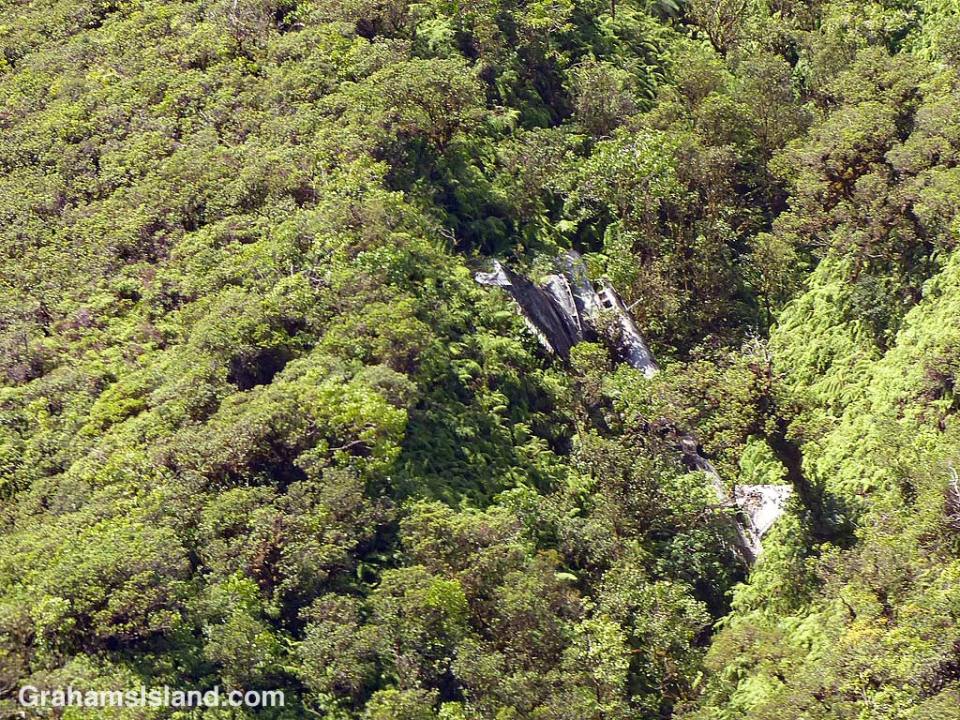
Better-Days-Wrecked Bomber in trees

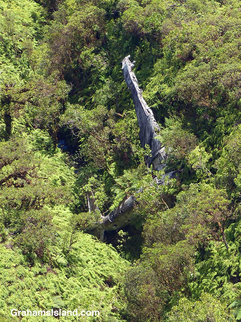
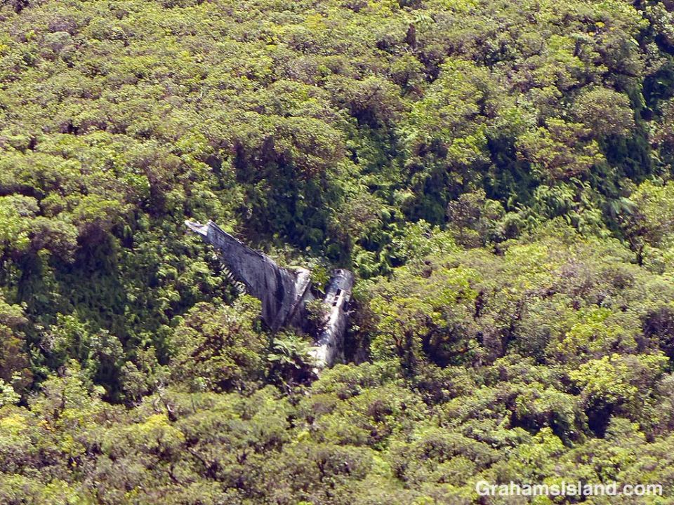
Better-Days-Wrecked Bomber in ravineOn the evening of Tuesday, February 25, 1941 this twin-engined B-18 bomber was part of a group of four aircraft on a night training mission. They had started out from Hickam Field on Oahu. Not far from Hilo the plane lost its port engine when a bearing failed. The pilot decided to try and reach Suiter Field (now known as Upolu Airport) at the island’s northern tip. It was not to be. Flying on only one engine, the plane lost altitude. The crew thought they were over the sea, but suddenly a mountain appeared in front of them. The pilot yanked on the flight yoke wheel and the plane stalled and flopped into the trees around 10 p.m.. Incredibly only one crewman was slightly injured.

Search aircraft from Hickam Field found the plane the next morning around 9 a.m.. The nose of the plane was hanging over a 75-foot deep ravine about 3,500 feet up on the northern side of Kohala Mountain. It was one of the most inaccessible places on the island. A rescue operation was started, but it was Thursday noon before it reached the crew.

Over the years, the aircraft has slid into the ravine which is where it rests today. As these photos show, the plane’s condition has deteriorated and it is increasingly being engulfed by trees. But it is still quite easily spotted from the air. On the ground, it remains one of the most inaccessible spots on the island.

It’s also worth noting that just nine months after this crash, almost all the B-18 bombers based at Hickam Field were destroyed on the ground during the attack on Pearl Harbor. 77 years on, this B-18, in its remote resting place, is one of only a handful remaining in existence.

For more information about this aircraft and the crash, search online for Big Island Bomber – hiavps.com or go to pacificwrecks.com/aircraft/b-18/36-446.html.
Better-Days-Wrecked Bomber

Green turtle closeup

Green Turtle closeup

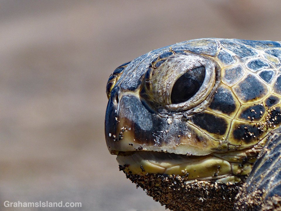
A Hawaiian green turtle lifts its head after resting on the sand at Kaloko-Honokohau National Historical Park. The park is one of many good places on the island to see turtles, either on the beach or foraging in the shallow waters there.

For more information about Kaloko-Honokohau National Historical Park, go to https://www.nps.gov/kaho/index.htm or bigislandhikes.com/kaloko-honokohau-park/.

Island hopping

Mokulele plane landing at Kona

Honolulu AirportIn Hawaii, it’s not unusual for people to commute between islands. Many medical professionals are based in Honolulu, but have offices on the Big Island which they visit on a weekly basis. The same can be said for other professionals: lawyers, scientists, engineers and the like. Politicians and government officials go back and forth on a regular basis.
But it’s not just professionals. Skilled tradespeople might work on any of the islands, commuting on a daily or weekly basis. Highway construction crews likewise move from island to island depending on where and what projects are being worked on. Musicians and other artists are regular island hoppers. The list goes on.

There’s one mode of transport for all these people and that’s air travel. There are no inter-island ferries. The Hawaii Superferry operated from 2007 to 2009 but was suspended when the Hawaii Supreme Court ruled that a second environmental impact statement was required. One concern with a ferry is the increased risk of spreading invasive species and diseases of plants and animals.

Hawaiian Airlines is the biggest operator in the islands, with the lion’s share of the inter-island business. It operates from its hub in Honolulu, but also offers direct flights between the other islands. The second photo shows the distinctive tails of a couple of its planes at Honolulu Airport.

Smaller airlines have also offered inter-island routes. These include Aloha Airlines, Go! Airlines and Island Air. These three ceased business in 2008, 2014, and 2017 respectively. Currently, the only other island airline is Mokulele Airlines, though it doesn’t fly to Kauai. They service some smaller airports and operate smaller planes such as the one above, coming in to land at Kona Airport.

Posted in response to this week’s Sunday Stills challenge is on the theme of ‘Transportation or Commute.’ (More responses here.)

South Point surge

South Point surge

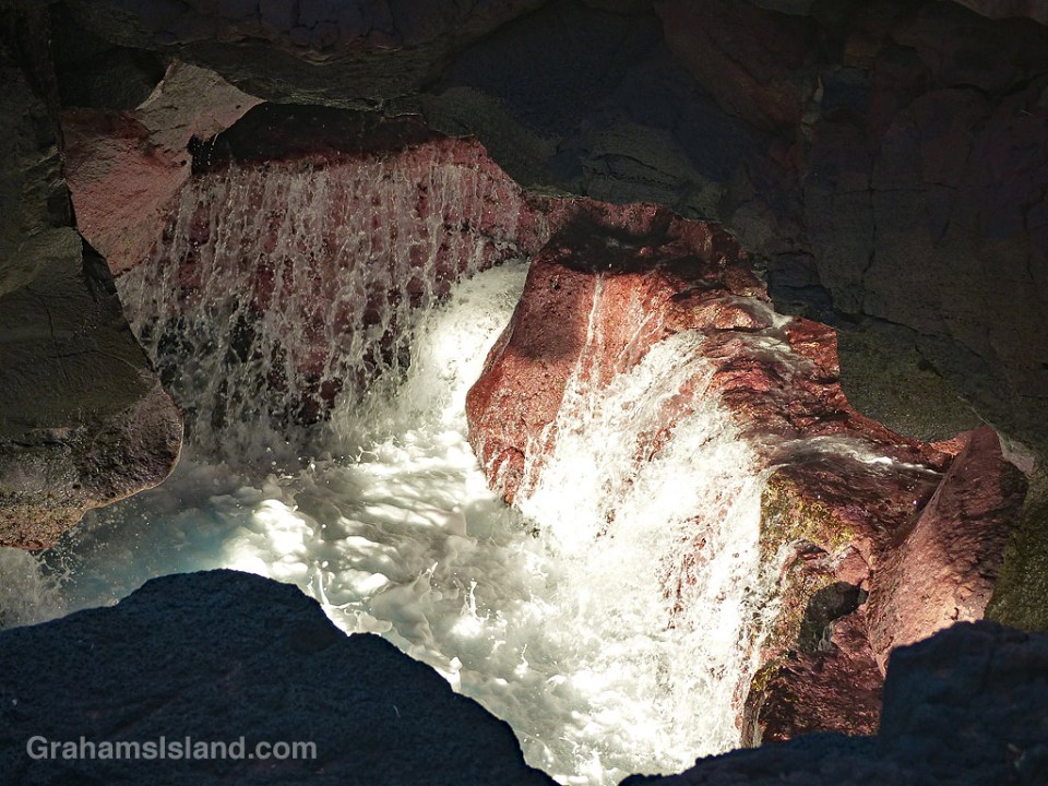
There’s a lot of current and swell at South Point, the southernmost tip of both the Big Island and the United States. Not far from the spot where people jump off the cliff into the ocean (not all of them make it back alive!), there’s a hole in the cliff where water surges in and out. This spot also has an opening above and is a great place to watch this wave action. I particularly like the pink rocks and the frothy white water as the waves recede.

Signs: No Lay Net

Signs-No Lay Net

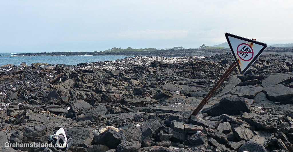
Lay nets are also known as gill nets. They can be hundreds of feet long and many feet deep with floats on the top edge and weights on the bottom. The problem with them is that, rather than targeting specific food fish, they can catch anything swimming by including turtles and monk seals. Because of this, they’re banned in certain areas, though not everywhere in Hawaii.

To me, this photo represents how the ban works. This section of the Kona coast is one of those areas where lay nets are banned. Someone has gone so far as to erect a sign in the lava near the coast. But that’s about it. In due course, the sign will fall down. It probably won’t be replaced. In the meantime, enforcement of the ban is spotty at best. Even when a violation is called in, chances are no one will be out to check on the situation until long after the net has been hauled and the netters gone home.

Return of the Pacific golden plover

Pacific golden plover feeding

This week’s Sunday Stills challenge theme is ‘Autumn,’ (more responses here) which poses a bit of a challenge. In Hawaii, we don’t have leaves turning color or a certain crispness in the air. But what we do have at this time of year is migratory birds coming to the islands.

One of the more impressive of these travelers is the Pacific golden plover. These birds spend the summer, their breeding season, in the Arctic tundra from western Alaska to northern Asia. At the end of the season they make an epic migration south to places as far away as Australia, Southeast Asia, and northeast Africa.

Hawaii is a stopover on their way to Australia, New Zealand, and other Pacific islands, but some of the birds spend their winters in Hawaii. This is a non-stop journey of more than 2,500 miles and takes the birds three to four days. How they do this is not fully understood. There are no landmarks or stopping points en route and no room for errors in navigation. But year after year, Pacific golden plovers return precisely to the same sites. Not only that, but new born plovers are able to make the journey independently despite never having flown the route before.

Then there’s the small matter of how this little bird fuels itself for such a long flight. There’s a fine balance between the amount of fuel it must carry and the need to fly fast. But even if it gets this right, the fact is an individual plover still wouldn’t be able to go that far. The secret lies in the birds flying in a V-formation which saves enough energy for the birds to make the whole distance with a little bit to spare to cover adverse conditions. It’s a remarkably precise balance which the birds manage successfully year after year.

This plover was foraging (successfully in the top photo) in tide pools along the Kona coast.

For more information about the Pacific golden plover’s migration to Hawaii, go to https://phys.org/news/2011-06-plovers-tracked-pacific.html.

Pacific golden plover

Kohala Ranch

Kohala Ranch

This is an aerial view of Kohala Ranch on the left and Kohala Estates on the right. The main road, Akoni Pule Highway, runs across the photo just above the coastline. The dark strip running across near the top of the land is Kohala Mountain Road, the darkness being the trees which line much of the road.

Kohala Ranch is a gated community which spans the space between these two roads. Near the bottom, houses are built on lots of one to three acres. Midway up the hill are five acre lots, and toward the top are bigger lots of 10 and 20 acres. The community has access to both roads. The top of the community gets more rainfall, and more wind, than the lower sections. Kohala Estates connects only to the bottom road.

Communities such as these are fairly common on the Big Island. Some are gated, some not, but most cater to people moving to the island from elsewhere since the property prices tend toward the upper end of the market.


Horses with a view

Horses and the ocean

I used to see these four horses frequently when I went for walks. They’re still around, but not as accessible as before. This pasture has been sold and is now used to grow Hawaiian heirloom sugarcane for use by a rum micro-distillery.

Another thing that’s changed is that the brown grass has been greened up by the last two hurricanes, both of which have dumped a good deal of rain, but generated very little in terms of wind, at least around here.