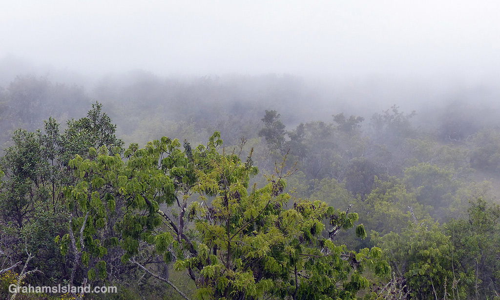
The scrubby woodlands on the side of Mauna Kea take on an eerie air when the clouds roll in.

The scrubby woodlands on the side of Mauna Kea take on an eerie air when the clouds roll in.

In Hawaii, a pu’u is a hill. These are old cinder cones that dot the landscape from the coast to the top of Mauna Loa and Mauna Kea.
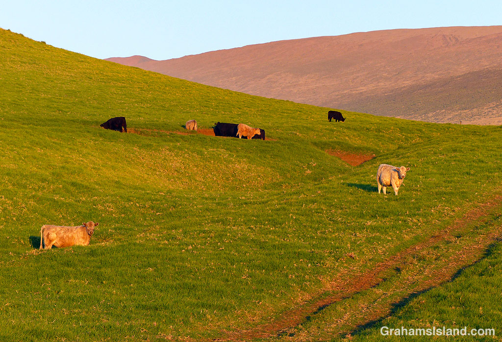
Along Old Saddle Road, the land and it’s pu’us are grass-covered. This pastureland is cattle, horse, and sheep country, with a lot of goats thrown in for good measure. The land is steep and and rough and the grass varied, but the rainfall is heavy enough that there’s a lot of it.
Old Saddle Road is one of my favorite drives on the island, particularly in the early morning (above) and late afternoon (below).
Posted in response to Friendly Friday challenge theme of ‘Splendour in the Grass.’ See more responses here.


Halemaumau Crater, at the summit of Kiluaea Volcano, underwent profound changes during the 2018 eruption. When lava drained from the summit vent, the crater floor experienced a series of collapses, radically changing the appearance of the crater and its surrounds.
I had seen this area from the air and posted about it (here). The middle photo was taken during that flight and shows where a section of Crater Rim Drive slid into the crater. When I last visited the park, I got a different view of this.
The recently reopened Byron Ledge Trail has good views across the crater. In the top photo, the chunk of road is clearly visible with its white line running down the middle of it. The bottom photo shows the longer view across the crater with the road in the distance. In the center of the photo, equipment used to monitor the volcano’s activity, can be seen. The tree in the foreground is an ‘ōhi‘a lehua with its brilliant red flowers. It’s an early colonizer of new lava flows and all those little dark spots on the main crater floor are ‘ōhi‘a lehua trees, mostly still shrub-sized at this time.


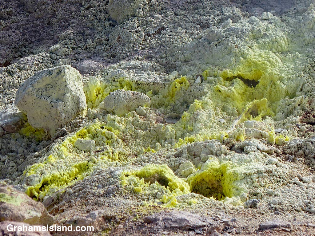
One of the trails I took on my last visit to Hawaii Volcanoes National Park was the Sulphur Banks Trail, otherwise known as Ha’akulamanu Trail. It’s not far from the visitor center and so is usually popular with visitors because it’s an easy walk, about 1.2 miles roundtrip, and pretty level the whole way. But with few visitors around currently, I had the trail to myself.
This trail is one of several areas in the park where signs of volcanic heat can be seen even when there’s not an active eruption. Steam swirls upwards. The smell of rotten eggs indicates the presence of hydrogen sulfide in the air, one of the volcanic gases leaking from the ground along with sulphur dioxide and carbon dioxide.
The yellow tint of the ground is due to the sulphurous gases and close examination reveals the sulphur crystals that have been deposited there. The crystals photo was taken at one of the displays along the trail. It wouldn’t be wise to thrust one’s camera too close to one of the active vents, such as those in the bottom photo.
For more information about Hawaii Volcanoes National Park, go to nps.gov/havo/.
Posted in response to this week’s Friendly Friday challenge theme of ‘Close Examination.’ See more responses here.

Hawaii Volcanoes National Park recently opened up more areas of the park that had been closed because of the Covid-19 virus pandemic. I thought this was a good opportunity to hike some of the summit trails that I usually avoid because they’re more accessible and popular with tourists. I put together a loop hike that would have been great had all the trails listed as open actually been open.
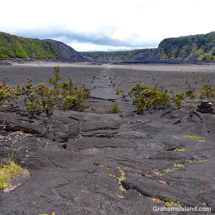
Despite this glitch, I had a good time and enjoyed the variety of landscapes the park has to offer. The top photo shows the part of the Kilauea Iki Trail that traverses that crater. The crater floor is a little under a mile across. This crater used to be much deeper before an eruption in 1959 filled it up another 400 feet. There is some vegetation, but the crater floor is mostly bare lava and steam can often be seen rising in various places.
The middle photo was taken on the Halema‛uma‛u Trail, which winds down from the summit into Halema‛uma‛u Crater. Despite the trail’s proximity to the vent in the crater, which was active until May 2018, vegetation thrives here as it does on many trails in the park.
The bottom photo shows a section of active steam vents alongside the Crater Rim Trail. This section of the trail is paved because the area normally sees very heavy use. When I was there, it was mostly deserted because of the lack of tourists on the island. The buildings on the horizon are the Volcano House Hotel which recently reopened for business, though the restaurant is still closed.
For more information about Hawaii Volcanoes National Park, go to nps.gov/havo/. For more information about Volcano House Hotel, go to hawaiivolcanohouse.com/.
Posted in response to Becky’s July Squares challenge theme of ‘Perspective.’ See more responses here.
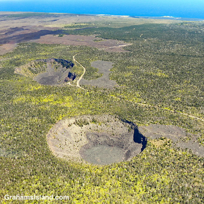
A view from the air gives a different perspective on Chain of Craters Road in Hawaii Volcanoes National Park. The road winds it’s way from the park entrance down to the coast. And why is it called Chain of Craters Road? Well, there are two big clues in this photo.
For more information about Hawaii Volcanoes National Park, go to nps.gov/havo/.
Posted in response to Becky’s July Squares challenge theme of ‘Perspective.’ See more responses here.

One of the nice things about the hike up Pu’u Wa’awa’a is the selection of benches available for rest and contemplation, on the way up and at the top. This bench sits halfway up the steep slope that accesses the top of the hill. It gives a good view of Mauna Loa and the pastures on and around Pu’u Wa’awa’a. If you’re lucky, you might even see a dung beetle or three doing what they do.

A view of Mauna Kea from the Pu’u O’o Trail off of Saddle Road, with a couple of telescopes peaking up at the top.
