This week’s Sunday Stills challenge theme is ‘Peace.’ See more offerings here.
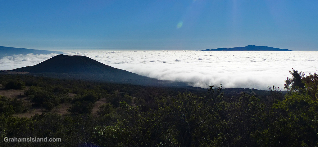
I’ve always found looking down on clouds gives me a peaceful feeling. Those fluffy balls of cotton wool look like they would make a comfy resting place. The irony is that those clouds may actually conceal roiling, turbulent air currents that are anything but peaceful, but let’s not allow reality to spoil the image.
This cloud layer blanketed the saddle between Mauna Kea and Mauna Loa. The two peaks poking above the clouds are, in the foreground, Pu’u Ahumoa, and in the background, Hualalai.
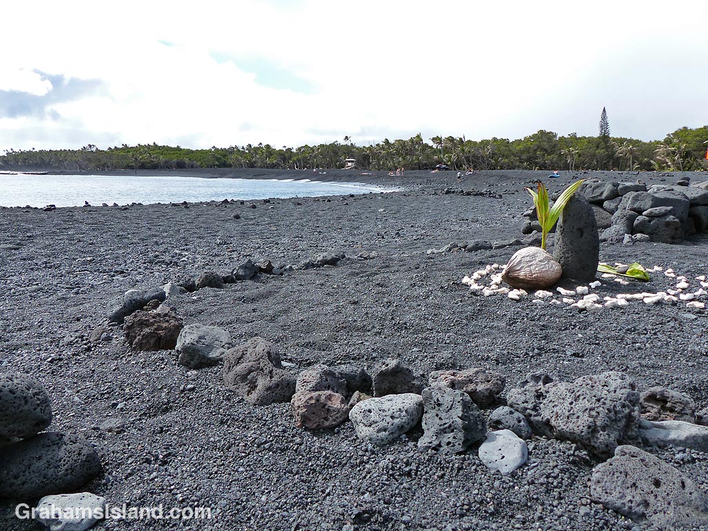
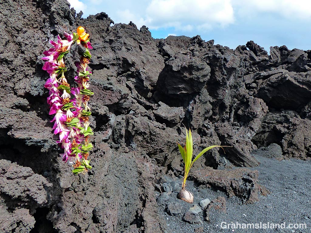
The Big Island’s newest black sand beach, at Pohoiki, was formed during last year’s eruption of Kilauea Volcano. Soon after its formation, offerings appeared at the beach and coconuts were planted.
For coconut planting, all that’s required is to plunk an unhusked coconut on the beach and wait. The coconut will sprout, as in these photos, but it can still be moved after it has sprouted as its roots are mostly fairly shallow. It’s tolerant of salinity, but likes regular rainfall, both of which are features of this location.
In several years, this somewhat stark black sand beach will become another scenic palm-lined tropical beach. That’s assuming the volcano doesn’t send another flow in this direction, in which case it might look more like the background of the bottom two photos.
This week’s Friendly Friday challenge theme is ‘Dramatic.’ See more responses here.
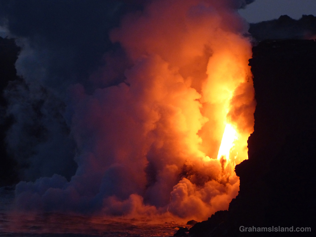
I’ve opted for a dip into the archives for this challenge. Two years ago, lava from Kilauea Volcano’s Pu’u O’o vent reached the ocean, tumbling down a cliff into the water. One day, the cliff collapsed, leaving the lava shooting out of a hole high up in the new cliff. This was called the firehose of lava because that’s what it looked like.
I first learned about it when I saw a video of the lava firehose on one of the news channels. What impressed me was that it was really hard to to see that it was a video. The flow was so strong and so consistent that it looked like a photograph. It was only by looking closely at the edges of the firehose that I could make out spatters of moving lava.
I headed down to the volcano, to take at look at this phenomenon, the day after I saw the video and was duly impressed by the dramatic scene. It was well worth the trip and well worth my quick visit. The following day another cliff collapse moved the firehose back and out of sight from the observation areas.
These are two photos from that visit. More photos can be seen in previous posts here, here, here, and here.
This sign guards what is presumably Hawaii’s heavy water plant, though why such a plant would be halfway up the side of Mauna Kea is a mystery. Or perhaps the sign is just a warning that it would not be a good idea to pick up the large water tank behind the sign. Either way, the sign made me smile.
This week’s Sunday Stills challenge theme is ‘Lines and Squares.’ See more offerings here.
This is one of the roads in Isaac Hale Beach Park at Pohoiki. This park is where last year’s lava activity came to a halt leaving a wall of lava making a border to the public area of the park. Walking beyond the ‘No Trespassing’ sign won’t result in your immediate arrest, but the powers that be don’t want people walking on the flow itself.
But this is a road after all and the sign makes it seem likely that someone driving here might continue on and run into the flow. Actually, this is entirely possible, given how some people drive around here.
Regardless of the intent, I like how the lines on the road disappear into the lava and the red squares are warning signs.
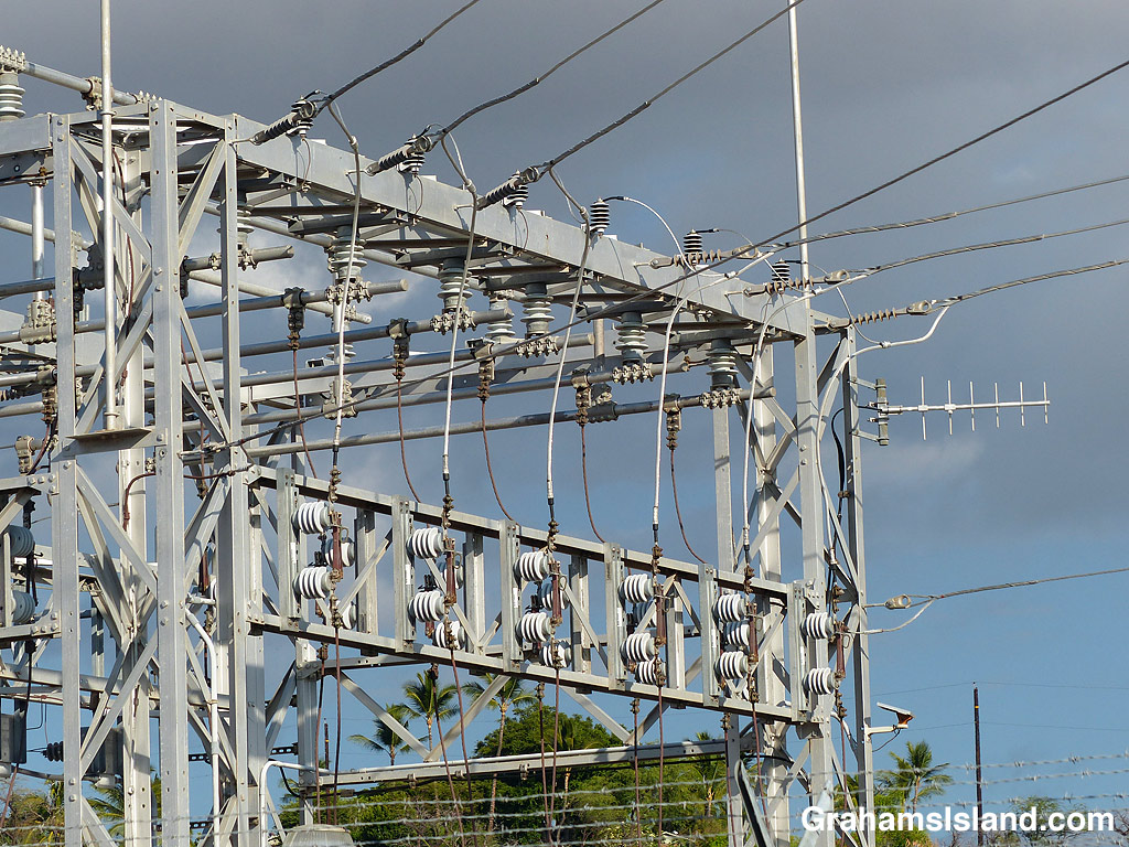
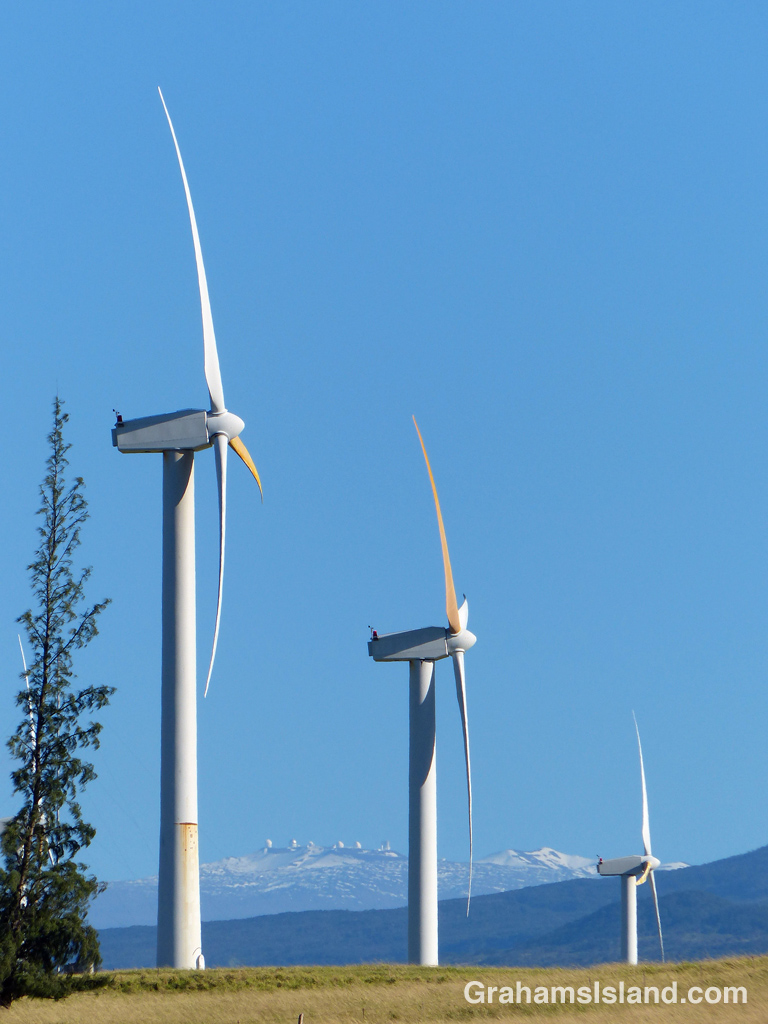
This week’s Friendly Friday challenge theme is ‘Electric.’ See more responses here. These three photos are quite different, but linked by this theme.
The top photo shows a view of an electric substation. I like the lines and shapes such facilities offer. But where does this power come from? A good deal is from oil fired plants, but Hawaii is working to get more of its electricity from locally sustainable sources.
In the middle is a view of Hawi wind farm, with Mauna Kea in the background. There are several wind farms of varying sizes in Hawaii including a few on the Big Island. Their contribution to the power grid is small, but growing. Solar power is also a big contributor, on an individual house basis or for whole communities (here).
One source that provided around 25% of the Big Island’s electricity was the Puna Geothermal Venture (PGV). Last year’s eruption shut them down, though, as the bottom photo shows, the flows mostly missed the plant itself. I think a couple of their wells were covered by lava, but most were spared. Currently, they’re in the process of restarting power production. Not everyone here is a fan of this power source. The same can be said about the Honua Ola bioenergy plant, which will generate electricity from burning eucalyptus chips, but which is still to become operational.
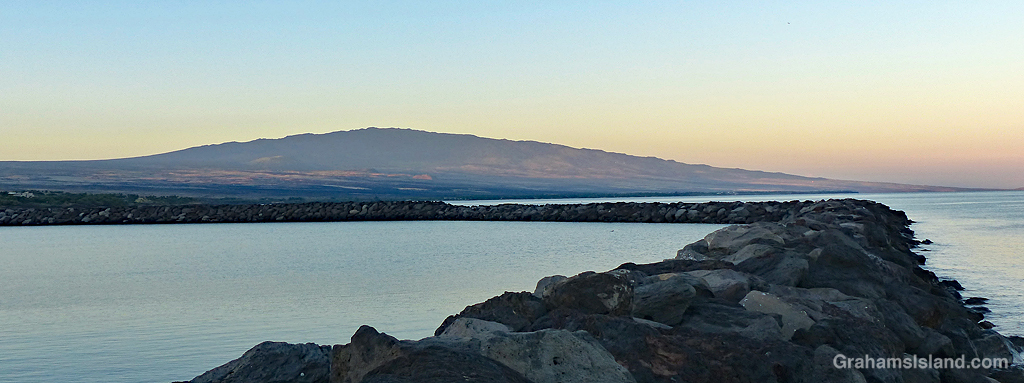
A view of Hualalai Volcano from the landward end of the breakwater at Kawaihae small boat harbor. I took this when I had a few minutes to spare on the way to work early one morning. I like being out at that time of day, not just for the light, but also for the quiet and the agreeable temperatures.
This week’s Friendly Friday challenge theme is ‘Remote.’ (See more responses here.)
I’m going for this photo for three reasons. First, Hawaii itself is remote at more than 2,200 miles from the nearest major landmass. The closest U.S. state is actually Alaska, though California is the closest state to the Big Island.
Secondly, Mauna Kea is one of the more remote spots on the island, particularly these days. Protests over building a new telescope on Mauna Kea have resulted in the road up the volcano being closed for some weeks now with no end to the dispute in sight. So if a person wants to go to the top, a long and arduous hike is the only way.
Thirdly, the telescopes on the summit are there to explore the farthest reaches of the universe, and you can’t get more remote than that.