This week’s Sunday Stills challenge theme is ‘Straight.’ See more offerings here.
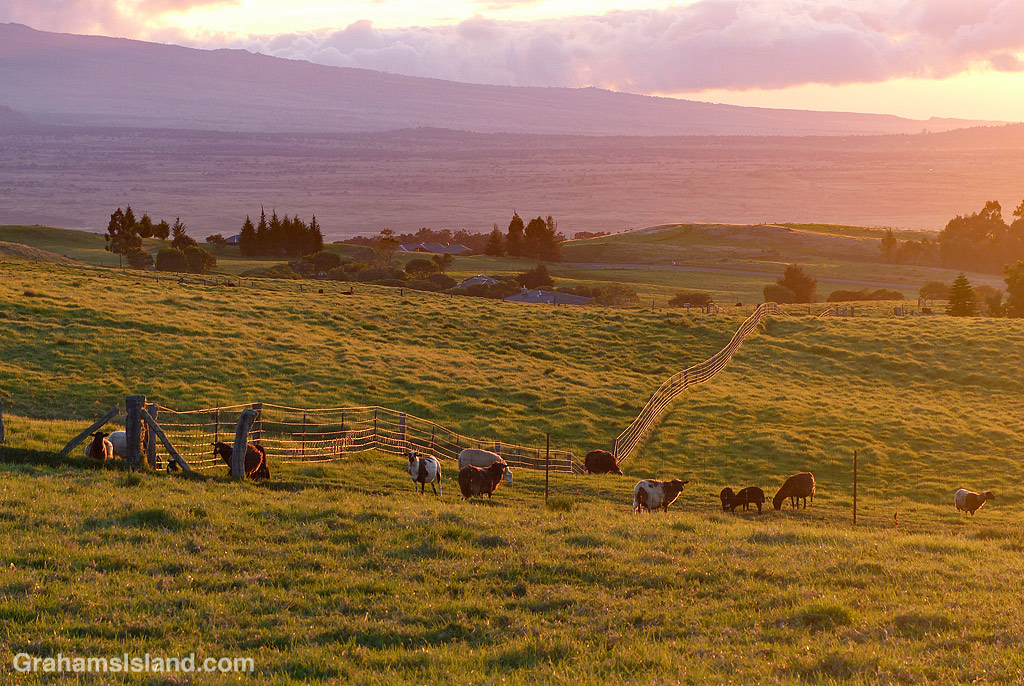
Last week, I revisited the Powerline Trail off of Saddle Road. This trail, when combined with the Pu’u O’o Trail, makes a good long loop hike. I like hiking the Pu’u O’o Trail because it passes through several kipukas (patches of old forest that have been spared by lava flows) and those kipukas have lots of birds living in them.
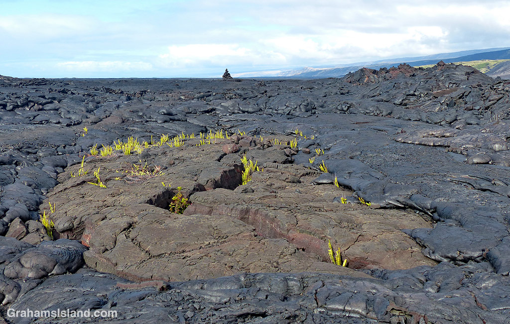
The Powerline Trail is a bit less interesting. There are fewer kipukas and it’s a long, exposed hike in a straight line across the lava. The reason for this can be found in the name. It follows an old 4-wheel drive road that serviced a power line that ran across the lava fields. The line is gone, but the sawn-off stumps of power poles can be seen alongside the trail (to the right of the trail in the top photo, to the left in the bottom photo).
One advantage the Powerline Trail has over the Pu’u O’o Trail can be seen in the bottom photo. This was near the end of my hike in the mid-afternoon as clouds closed in. It’s not unusual for this part of the saddle to be shrouded in thick fog and, if you happen to be out hiking in those conditions, the straight and clear Powerline Trail is much easier to follow than the Pu’u O’o Trail which, crossing the lava fields, can be hard to follow when you can’t see the cairns that mark its route.
The trail, of course, isn’t perfectly straight (though I suspect the power line was). It bumps around lava upwellings and collapsed tubes. But most of the time, one just needs to look up to see, straight ahead in the distance, the faint pale thread of the trail topping a hill or emerging from a dip in the landscape.
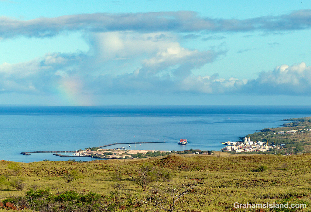
This week’s Sunday Stills challenge theme is ‘Waterworld.’ (See more offerings here.) So why this photo of Kawaihae harbor? Well, this was where the 1995 movie, Waterworld was filmed. Actually, most of the filming took place beyond the stubby rainbow in this photo, out there in the deep blue ocean.
The movie blew away its original budget, spectacularly overran its 96-day shooting schedule, and suffered a laundry list of disasters from start to finish. It started shooting without a finished script despite the efforts of multiple screenwriters. The director and the star had different ideas about how the movie should work. It was shot almost entirely on water. Actors and production crew got seasick. Two actors were dumped from a boat and then run over by it. Several of the cast were stung by jellyfish. A stuntman nearly died from the bends after a diving scene. The star himself was lashed to a mast, 40-feet up, for one scene but when it was over, a gale sprang up, and he and the boat couldn’t be retrieved for half an hour.
Bad weather often prevented any shooting and numerous delays carried the production into hurricane season. High winds duly destroyed one of the intricate and expensive floating sets.
The completion of filming didn’t end the movie’s traumas. The director quit before the editing was complete. Test audiences gave it a lukewarm reception leading to continued tinkering. Ultimately, the movie wasn’t a total disaster. While it didn’t do that well in the U.S.A., it covered its costs with overseas income. There’s even a popular Waterworld attraction at Universal theme parks.
I saw the movie when it came out and made it the subject of one of the weekly columns I wrote for my local newspaper. That column is reproduced below, as it was written at the time. Bear in mind that was 25 years ago and some things have changed in that time (if you don’t know what a VCR is, look it up!).
Waterworld on the rocks, no ice
I went to see Waterworld last week. That’s the movie that was supposed to be the most expensive ever made at around $100 million, but turned out to be the most expensive ever made at more than $175 million. It’s set way in the future when some cataclysm, such as the balancing of the Federal budget, has caused the polar ice caps to melt. The survivors live on wacky floating stage sets and dream of finding dry land and pizza without anchovies. Right from the start I was in trouble. Where was all this water coming from? I wondered. According to the Encyclopedia Britannica, if all the world’s ice melted, sea level would rise about 230 feet. While this would bode ill for the likes of New Orleans and Miami, there would still be quite a bit of land sticking up, such as Asia. I would have thought that someone, somewhere would have bumped into some of this land by the time the movie started, possibly during the previews of coming attractions. Still, as readers of this column know, I am not one to let facts get in the way of a story. Perhaps, in addition to the ice caps melting, it also rained a lot. Or, maybe, the cataclysm that caused the ice to melt was a gigantic alien intergalactic water tanker crashing into Earth. In any case, in this water-covered world the only clue as to the location of dry land is a little girl with a map tattooed on her back and a glossy real estate brochure offering view lots at attractive prices. This girl is sought by bad guys whose bad lifestyle includes riding jet skis, living on the Exxon Valdez, and worst of all, smoking cigarettes. (Presumably they’re stale cigarettes since there isn’t anywhere to grow tobacco and or any government to provide subsidies.) The bad guys are even called Smokers just in case anyone might not realize how thoroughly awful they are. Pitted against the bad guys is Kevin Costner sporting webbed feet, gills, and a mean temper. This may be because his last three movies bombed or it could be dissatisfaction at the amount of money being wasted instead of going into his pockets. Unlike Meryl Streep, who tends to research her character’s background and come up with appropriate behavior and accent, Costner acts in the John Wayne tradition. He sounds pretty much the same in Waterworld as he does in all his movies. For all I know his dialogue is the same. That could explain why the couple down the row from me decided to chat all the way through the movie. Now, I’m not an intolerant person (and anyone who says I am should be taken out and shot), but people talking through movies is one of my pet peeves. It drives me bonkers when something happens on screen and I hear someone ask, “What did he say?” By the time the explanation is given, another scene has gone by prompting the question, “What happened there?” They never catch up. This is why God invented the VCR. VCRs allow such people to have no idea what’s going on in the privacy of their own homes. They also avoid the risk of having me pour hot buttered popcorn on their heads. Playing opposite Costner in almost the only female role, apart from the girl with the map, is Jeanne Tripplehorne. You can tell hers is a supporting role because she did not get as much material for her costume as Costner and consequently ran short in the bosom area. Not that I’m complaining. One reason there are so few women in the movie is because Waterworld is an action/adventure movie. Hollywood rules state that in action/adventure movies, women cannot appear for more than about 20 minutes and during that time they must be either naked and/or get killed. Because it’s an action/adventure movie, it also features a stipulated number of explosions, fires and, of course, meaningless violent deaths. There is even a mandatory car chase, not an easy thing to work in when the freeways are deep under water. Actually that scene is one of the many tongue-in-cheek bits in the movie. In fact, apart from Costner being permanently cranky, everyone else seemed to be having a pretty good time, albeit while acting as though they’re desperate and starving. It may be that this lighthearted attitude spilled over to the accounting department of Universal, the company that made Waterworld. That was my first thought to explain where the $175 million went. But then I noticed that all those fires burning through the movie were fueled by studio executives throwing actual dollar bills into the flames. I understand that, in an attempt to recoup some of their costs, Universal plans a sequel. It’s about a movie studio that drowns in a sea of red ink when the accounting department’s computers crash and burn. It will be called Realworld.
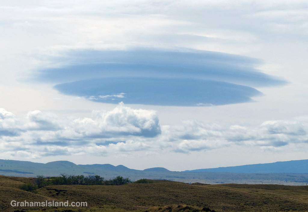
This vary strange looking cloud formation appeared one day atop the saddle between Mauna Kea and Mauna Loa. It hung around there for a long time before suddenly disappearing into space. No, not really. Instead, the lower level clouds continued to build and eventually obscured the view of the alien cloud. All very mysterious.
This is the third and final part of a three-part description of a hike along the Puna Coast Trail in Hawaii Volcanoes National Park (See part 1 here, part 2 here).
The last part of the trail before ʻĀpua Point crosses over the only stretch of ʻaʻā lava on the trail which, as can be seen in the second photo, is markedly more rough and jagged than pahoehoe lava. This ʻaʻā is part of a 1969 flow from the same eruption at Mana Ulu that produced the pahoehoe lava that most of the trail passes over. The Mauna Ulu eruption lasted from 1969 to 1974.
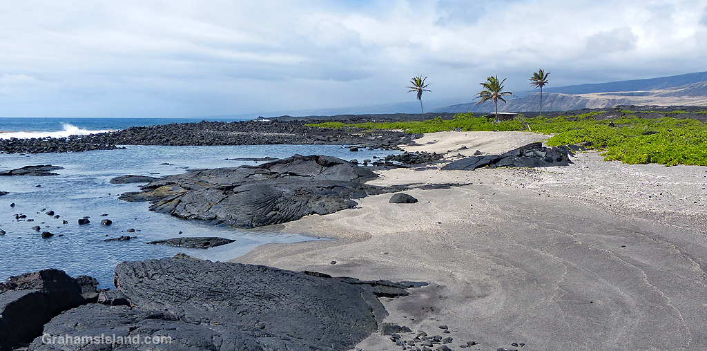
ʻĀpua Point is like a little oasis in a bleak landscape. Flows from the Mauna Ulu eruption reached the ocean on either side of the point, but the point itself was spared. The top photo is a panoramic view of the coast, stitched together (not well) from two photos, to show the view from ʻĀpua Point’s outhouse – actually a composting toilet. This toilet also represents the sum total of the facilities for anyone thinking of camping there.
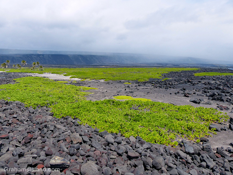
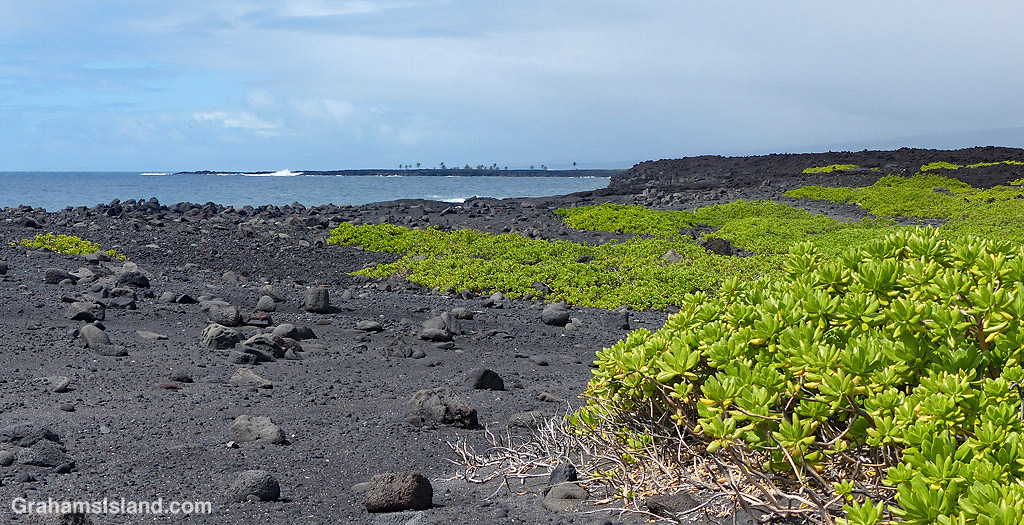
ʻĀpua Point itself is a rocky coastline jutting into the ocean. But behind this wall of rock, a sandier area hosts fields of naupaka, sea purslane, and other plant life, as seen in the third photo. Also in the background of this photo, a passing shower runs along Hōlei Pali. As I mentioned in part one of this description, the trail can be hot, wet, and windy, but for my hike, I saw moderate breezes, some overcast skies, and just a few spritzing showers.
Swimming in the ocean along this coast is very dangerous because of high surf and strong currents. But at ʻĀpua Point there are shallow pools, suitable for soaking, that are protected from the surf by a border of rocks. There are also a few small sandy beaches such as the ones in the photo below.
Besides the composting toilet, there is one other structure on ʻĀpua Point. It’s a small shed with an open covered area beside it, surrounded by naupaka and a few palm trees. This covered area represents pretty much the only shade to be found on the entire hike. The shed is used by the Hawksbill Sea Turtle Recovery Project, which monitors and protects endangered hawksbill turtles which use this area for nesting. I believe the nesting season runs from May to September, so I might have to return sometime after that.
And speaking of returning, from here it was time to turn around and hike the 6.6 miles back to the car. The hike took me about 3 hours each way with, of course, numerous stops for photography and just to enjoy the views.
This is the second part of a three-part description of a hike along the Puna Coast Trail in Hawaii Volcanoes National Park (See part 1 here).
As the trail reaches the coast, it passes over an older flow that has a fair amount of vegetation on it. The third photo shows the trail cutting through a swathe of naupaka, sourbush, and assorted grasses.
This area was, despite the threat of volcanic activity, well occupied by early Hawaiian people. Along the trail are several reminders of that including the structures below. The photo, below middle, shows the amazing abilities of plants to grow in even the most daunting locations. The roots are somewhere deep in the lava, from which the trunk of this noni snakes upward. The large, nobbly fruit can be seen on this plant. This fruit, when ripe, has a pungent aroma which supposedly smells like vomit!
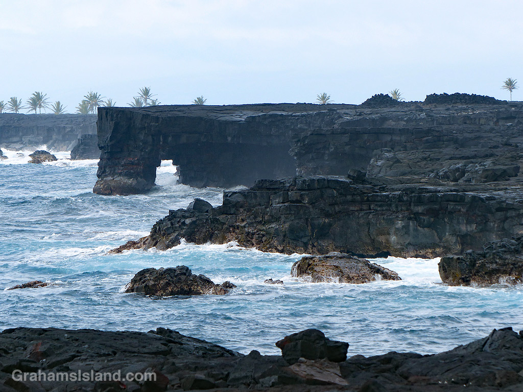
The bottom photo shows an area of rocks and black sand on the coast, backed by an extensive field of naupaka. Beyond that, the trail passes close to a pair of sea arches seen in the top photo and the one at top right. This is a rugged coastline and, when the weather is rough, huge waves can crash up and over the lava. It’s also an unstable coast with rocks and sections of cliff liable to tumble into the ocean.
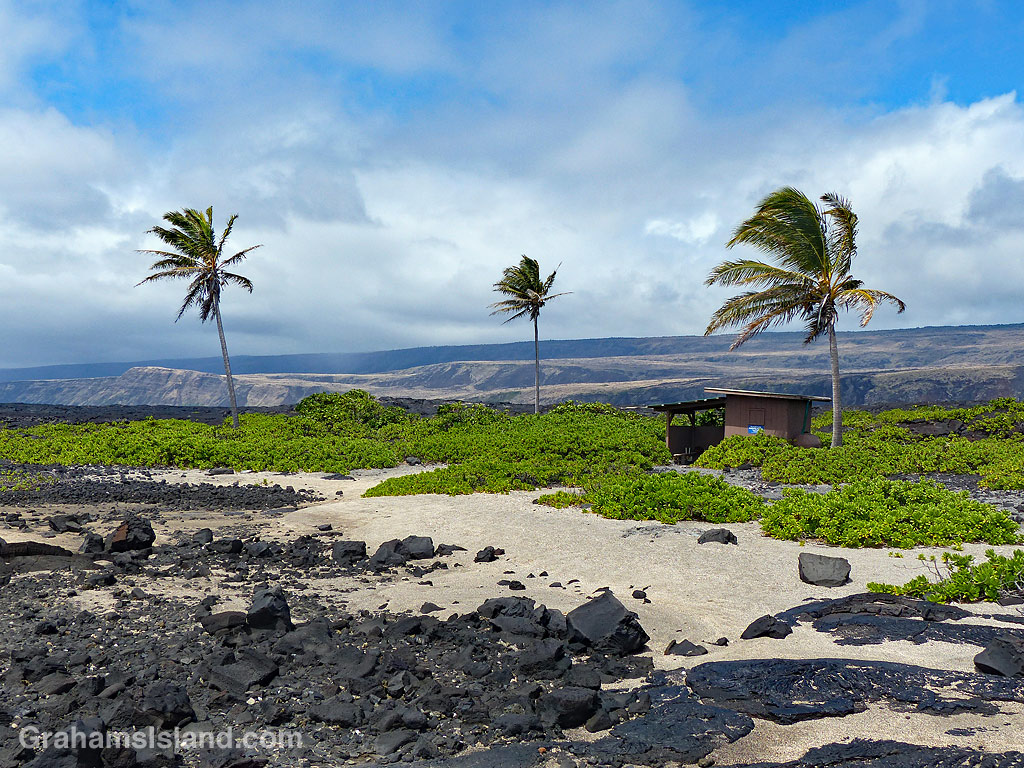
In the background of the top and bottom photos are the palm trees of ʻĀpua Point, which will be the focus of the third and final post about this trail, tomorrow.
Last month, I posted photos of colorful lava (here) that I saw on a hike I’d just done. In that post, I noted that ‘I’ll do a post about the trail once I’ve gone through the way-too-many photos I took that day!’ With all that’s been going on in the interim, processing those photos took a long time, but now I’m done. So here’s the first of three posts about the trail, not that you can follow in my footsteps right now because Hawaii Volcanoes National Park is currently closed.
As the name indicates, the Puna Coast Trail travels along the coast of the park, but it starts about a mile inland, across Chain of Craters Road from the Pu’u Loa Petroglyphs trailhead. The trail is 11.3 miles long and ends at Halapē campground, but I only hiked as far as ʻĀpua Point, 6.6 miles along the trail. This rugged trail can be hot, windy, and wet so sturdy shoes or boots, a hat, sunscreen, and raingear are a must. There’s no fresh water on the trail so take plenty, as well as enough to eat.
The trail starts by crossing the 1972 flow from an eruption at Mana Ulu. In the top photo, lava from this flow surrounds a small area of older lava. The ferns growing in the cracks are Polypodium pellucidum, an endemic fern known in Hawaii as ae (pronounced Ah Ay). These ferns are among the first plants to grow in new lava fields. The faint outline of the trail can be seen extending from the middle left of the photo to the cairn on the horizon.
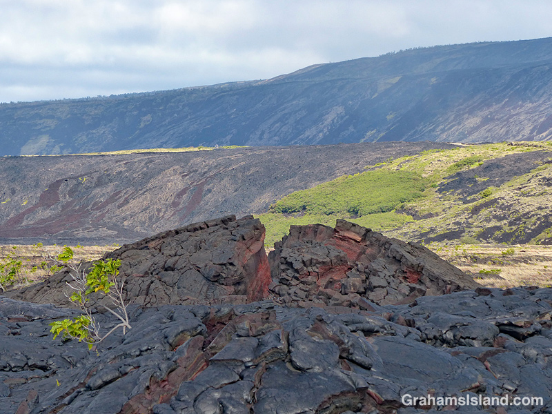
Second photo: An upwelling in an old lava flow has cracked open to reveal a variety of colors within. In the background is Hōlei Pali. A pali is a steep slope or cliff. When a flow goes over a pali, it can often be seen, safely, from a distance away.
Third photo: A trail-marking cairn on a section of older lava that has been somewhat revegetated. The noni (Morinda citrifolia) shrub beside the cairn is another early colonizer of lava flows being tolerant of the harsh conditions found there. Noni is a ‘canoe plant,’ having been introduced to Hawaii by the first Polynesians who arrived in their ocean going canoes.
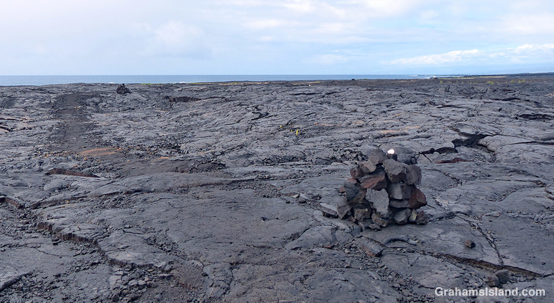
Fourth photo: Cairns mark the trail across the expanse of lava from the 1971 flow, where very little vegetation can be found. This first part of the trail angles down toward the ocean, which can be seen in the distance.
Below: Colorful smooth pahoehoe lava lies on top of ropey pahoehoe lava, from the same 1971 flow. The kind of lava can change quite quickly as conditions change in the flow itself and the terrain it travels through. This also shows the colors in different layers of lava as well as an ae fern getting a toehold.
Bottom: A little hill of pahoehoe lava showing its different forms all jumbled up. I almost included this photo in the earlier post since its colors, textures, and swirls were unexpected art for me.
Tomorrow, part two follows the hike along the coast itself.