Tag Archives: Hawaii Volcanoes National Park

Lava lake rising

Kilauea lava wall of flame

Kilauea lava lake lines

Kilauea lava morning

The Overlook vent, in Halema’uma’u Crater at the summit of Kilauea Volcano, has been active since 2008. The level of the lava in the vent goes up and down, mostly 100 feet or so below the crater floor.

Last week, I was looking at the daily activity report and saw that the level was just 30 feet or so below the crater and lava was again visible from Jaggar Museum for the first time since April, 2015. My wife and I had visited during that previous viewing window and thought we’d like to do so again, particularly if the level rose until lava spilled onto the crater floor.

Next day, the level had dropped 40 feet. So much for that. The day after, it was back up 30 feet. We decided to monitor the situation. The lava kept rising, and over the weekend spilled out beyond the vent. Then it went down again. Then it came up again. Etcetera, etcetera.

On Monday, the lava spilled out over the crater floor and we thought about going early Tuesday, but the level dropped and we decided to wait. Tuesday morning, lava was spilling out. We decided to definitely go Wednesday morning (yesterday).

As noted in the previous post here, the issue is that the volcano is about 100 miles from where we live, a two-and-a-half to three-hour drive. Last time we got up at midnight to begin the journey. This time, we gave ourselves an extra hour’s sleep, trading that for breakfast at Ken’s in Hilo at 3 a.m..

So alarms went off, coffee was made, and tiramisu eaten (breakfast of champions), and we hit the road. Happily, the trip over was made under a mostly clear, starlit night and we rumbled into the Jagger Museum parking lot right on schedule at 4:30 a.m.. This time we were better prepared with actual warm clothing. With clear skies and a moderate breeze, it was chilly, especially for Hawaii.

There were already several people there, but not as many as in 2015, so it was easy to find a good viewing spot. Alas, we didn’t get to see lava spilling out because, as I learned later, the volcano had begun a mild deflationary phase (going down) after spilling out in even earlier hours of the morning.

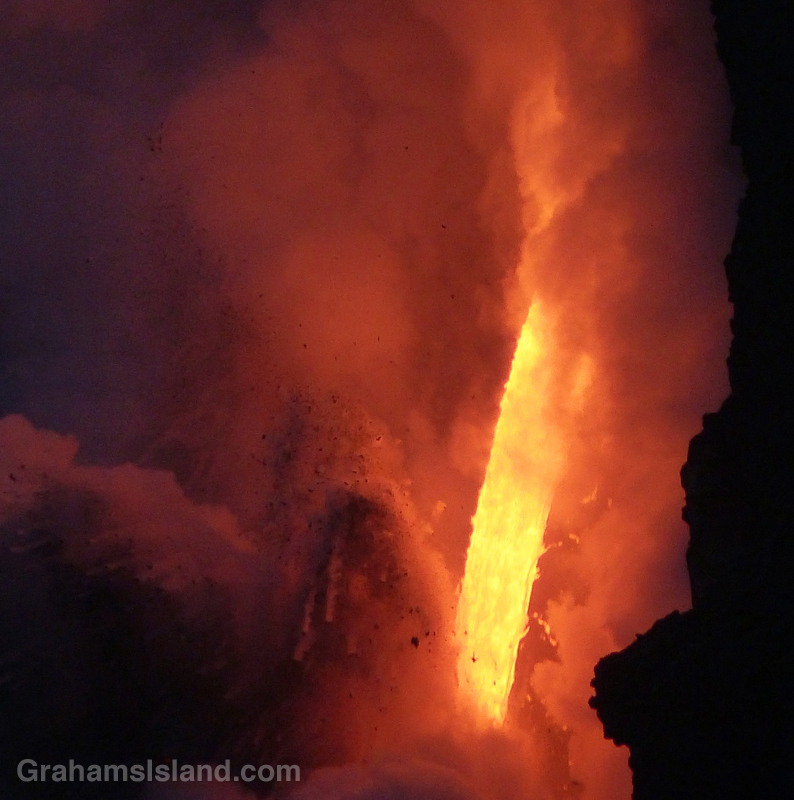
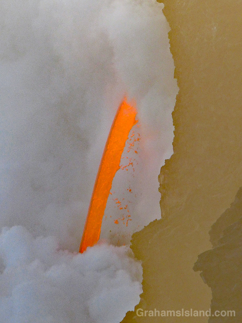
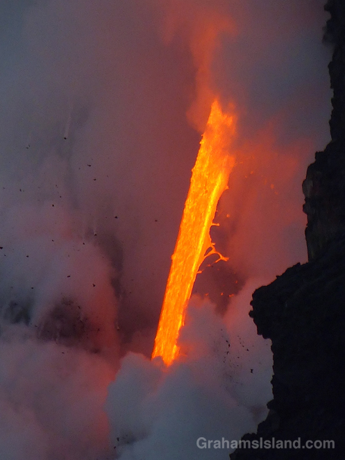
Still, it was worth the journey. For a while, the lava lake was quite active, bubbling away and throwing up spatters in several different areas. One of the things I like about the lava lake, when it’s visible, is that the surface is mostly dark, but it’s cut through by ever-changing lines of bright lava. Sometimes, lava will burst forth from these lines in a frothing hotspot. Other times, a line might disappear as activity moves elsewhere.

These photos show activity along the crater wall (top), a hotspot on the edge of the pool (second photo), morning light seeping in above the volcano (third photo), an active hotspot in the center of the lava lake (bottom).

Posted in response to this week’s WordPress Photo Challenge ‘Lines.’

Kilauea lava lake

Pu‘u Loa petroglyphs

Not far from the coast, in Hawaii Volcanoes National Park, is Pu‘u Loa petroglyphs trail. It’s only a mile and a half round trip, but visits a place with a huge number of petroglyphs. A raised boardwalk circles part of this area, giving a good view of the petroglyphs without adversely impacting them.

One of the main features of this area and its petroglyph field is explained on a display seen in the second photo. It reads, ‘The name Pu‘uloa (large hill) carries a kaona (hidden meaning)—hill of long life. Families with genealogical ties to these lands come here to place the piko (umbilical cord) of their child. Their hope is that the mana (spiritual guiding energy) of Pu‘uloa would bless that child with a long and prosperous life, and root them to their ancestral lands. Each puka (hole) is created to house a single child’s piko. Of over 23,000 petroglyphs found at Pu‘uloa, 16,000 are piko-related carvings—a testament to the importance of both Pu‘uloa and ‘ohana (family).’

For more information about Pu‘u Loa petroglyphs, go to https://www.nps.gov/havo/learn/historyculture/puuloa.htm.

(On the park’s website, Pu‘u Loa is two words, but on the sign it is one word, hence the inconsistency.)

Sriracha the Bengal tiger

Sriracha, a female Bengal tiger, paces at Pana‘ewa Rainforest Zoo in Hilo.

This week’s WordPress photo challenge is to choose your favorite photo taken in 2017. I’m going with a photo that I haven’t posted before (though below I offer a few of my favorites that have run).

This is Sriracha, a female Bengal tiger and cousin of Tzatziki, a white male tiger. Both can be found at Pana‘ewa Rainforest Zoo in Hilo. What I like about this photo is those huge paws, the quiet movement, and the sense of great power that could be uncoiled at any moment.

For more information about Pana‘ewa Rainforest Zoo & Gardens, go to hilozoo.org.

As far as favorite photos already posted are concerned, I offer a few here:

Top. A gold dust day gecko drinking from a bird of paradise flower is a blaze of color (posted here).

Second. This photo captures the awesome spectacle of the lava firehose from Kilauea Volcano pouring into the ocean (posted here). Currently, while the flow is still active, lava is no longer entering the ocean.

Third. I was happy to snap the moment a passion vine butterfly laid an egg (posted here). This was taken on the same day as the gecko photo above, so a banner day for me.

Fourth. I like all the photos in this post for their color and how they capture something of this most Hawaiian of dance (posted here).

Finally, I love this gargantuan blenny for its name, and was very pleased to get this photo, since the fish is apt to dart away and the shallow water was rocking (posted here).

Kilauea Iki Crater trail

A group of people, looking very small, walk the trail across Kilauea Iki Craterfloor.A group of people, looking very small, walk the trail across Kilauea Iki Craterfloor.

These views of the trail across Kilauea Iki Crater, taken from the rim of the crater, give some idea of the scale of Kilauea Volcano.

Above, a group of people, looking very small, walk the trail across the crater floor.

To the left, smoke and gases from the active vent in Halema’uma’u Crater can be seen. Halema’uma’u Crater is part of the Kilauea Caldera which is much, much bigger than Kilauea Iki Crater. And, yes, that same group is still visible on the trail in this second photo, along with several others hiking the trail.

For more information about Hawaii Volcanoes National Park, go to nps.gov/havo/. For more information about Kilauea Volcano and it’s eruptions, go to hvo.wr.usgs.gov/kilauea/history/main.html.

Fire from the volcano

Lava from Kilauea’s Pu’u O’o vent pours into the ocean.Lava from Kilauea’s Pu’u O’o vent pours into the ocean.Lava from Kilauea’s Pu’u O’o vent pours into the ocean.

Since the theme of this week’s WordPress photo challenge is elemental, I thought I’d pull out a few more photos from my visit, earlier this year, to the lava flow from Kilauea’s Pu’u O’o vent.

This is the closest we get to seeing fire from the earth’s core, a roaring torrent of molten lava. Since I took these photos there have been cliff collapses that have ended this firehose effect. But the lava continues to flow and has formed a good-sized delta at the foot of the cliff. This delta is crossed by several large cracks, which run parallel to the coast. This means the whole delta is likely to collapse into the ocean in the near future, probably in explosive fashion.

Could be time for another visit!

Lava from Kilauea’s Pu’u O’o vent pours into the ocean.Lava from Kilauea’s Pu’u O’o vent pours into the ocean.

Helicopters circle Pu’u O’o vent

Tour helicopters circle Pu'u O'o vent on the Big Island of Hawaii

During a recent hike on the Nāpau Trail in Hawaii Volcanoes National Park, one accompaniment was the throb of helicopter engines. The active flow from Pu’u O’o vent, and its ultimate outpouring into the ocean, is a great attraction for visitors and locals alike.

One way of seeing these events is on a helicopter tour and, as I sat at the Nāpau overlook, I noticed there was a clear order to those helicopter visits. A pair would arrive from the west, one a bit behind the other. One would circle the vent, the other visit the ocean entry. Then they’d switch. After 10 or 15 minutes, the two helicopters would head off to the northeast and soon after, the next pair would arrive.

For more information about Hawaii Volcanoes National Park, go to nps.gov/havo/.
 For more information about Kilauea Volcano and it’s eruptions, go to hvo.wr.usgs.gov/kilauea/history/main.html.


The Nāpau Trail – Through the woods

A close up of the Puʻu ʻŌʻō vent of Kilauea Volcano.
A close up of the Puʻu ʻŌʻō vent.
The Napau Trail passes through dense forest.
I met Yogi on the trail just before entering the forest. Here, he makes his way through the dense growth.
Huge Hapu’u ferns line the forested section of the Nāpau Trail.
The old Pulu Factory on Napau Trail.
The old Pulu factory.

Yesterday, I posted about the first part of the Nāpau Trail in Hawaii Volcanoes National Park, which crosses extensive lava fields. Today’s post picks up from there, on the rim of Makaopuhi Crater, where the trail slips into dense forest on its way to the Nāpau Crater overlook.

The Puʻu ʻŌʻō vent from the Nāpau Crater overlook.
Puʻu ʻŌʻō from the Nāpau Crater overlook.

It’s a remarkable contrast between the stark lava and thriving forest. Birdsong is continuous. Ferns of every kind grow in abundance. Bamboo orchids pop out here and there. And above it all, tall Ohia trees provide the backbone of the forest. This forested trail is clear, but somewhat overgrown. I was hiking in shorts and, at the end of the day, my legs were generously scratched.

Early on in this section, it’s possible to get views of Makaopuhi Crater. Also in this area is the junction with the Nāulu Trail, which starts out at the Kealakomo Overlook, farther down Chain of Craters Road.

The forested part of the trail is about 2.5 miles and towards the end of it is an old Pulu factory. The sign there reads: “Between 1851 and 1884 great quantities of pulu, the soft, reddish-brown fiber covering the coiled fronds of the tree fern (hāpuʻu), were harvested on Hawaii. Much of it was processed within these walls, later to be shipped from Keauhou Landing to foreign markets for use as stuffing in pillows and mattresses.” Unfortunately, in drier climates, pulu quickly breaks down so the industry collapsed.

A little farther along is another junction. To the left is the very basic Nāpau campsite, a few open flat areas and an outhouse. To the right, the trail continues to the overlook, where I was lucky enough to have a wonderful, clear view of Puʻu ʻŌʻō, busily pumping out sulphur dioxide and other gases, and of course, million upon millions of gallons of lava, currently entering the ocean on the southeast coast.

Picking the right day for the hike is not always obvious and weather changes quickly around here. At the visitor center, on the way in, it was completely overcast and drizzling, but by the time I got to the trailhead the sun was out and a nice breeze blew. The wind direction is also important. On this day, the northeast trades were blowing and the vog trailed away to the southwest, which is fine for this hike. But if the wind blows more easterly or south of east, then this trail would be downwind of emissions from the volcano, which could potentially be a dangerous situation.

For more information about this, and other hikes on the Big Island, go to bigislandhikes.com.
For more information about Hawaii Volcanoes National Park, go to nps.gov/havo/.
For more information about Kilauea Volcano and it’s eruptions, go to hvo.wr.usgs.gov/kilauea/history/main.html.