Category Archives: Parks

Kilauea Iki Trail

This week’s Sunday Stills challenge theme is ‘Paths.’ (See more offerings here.)

Kilauea Iki Trail is one of the more popular trails in Hawaii Volcanoes National Park. But last year’s volcanic activity, with numerous earthquakes, resulted in the park being closed for several months. Even after it reopened in September 2018, many parts of the park remained closed because the areas were too unstable to be opened to the public.

The Kilauea Iki Trail was one of those areas along with Thurston Lava Tube and Jaggar Museum. The latter two locations are still closed and Jagger Museum may never be reopened, but the Kilauea Iki Trail is currently listed as mostly open. Given that this is a loop trail, it would be wise to check ahead and find out what ‘mostly open’ means.

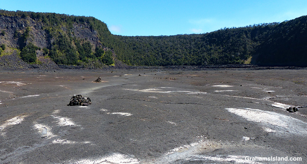
These photos were taken during a hike I took a couple of years back. The top photo shows the view from the part of the trail that follows the rim of the crater before it descends to the crater floor. The second photo shows two hikers heading out across the crater floor. The dark hill in the background is Pu‘u Pua‘i where a 1959 eruption poured lava out into the crater. The third photo shows hikers near the center of the crater where the path winds through broken areas of the crater floor. Below, cairns mark the trail across a flat area of the crater that leads to the switchback trail which takes hikers back up to the crater rim.

For more information about Hawaii Volcanoes National Park, go to nps.gov/havo/.

Halema’uma’u Crater

This week’s Sunday Stills challenge theme is ‘Danger.’ (See more offerings here.) It seemed a suitable opportunity to post some photos reviewing on Kilauea Volcano’s last eruption, which began in May of last year.

The bottom photo, taken from the Jaggar Museum overlook, shows the scene on the morning of April 25, 2018. Lava in the active vent in Halema’uma’u Crater, at Kilauea’s summit, was just below the crater floor and had been overflowing into the crater in previous days. The overflow is the large dark area to the right of the glowing lava.

By early May, the lava level in the vent had dropped around 1,000 feet. This drop occurred at the same time that lava disappeared from Pu’u O’o vent. Not long afterwards, cracks opened in the ground at Leilani Estates, a housing subdivision in the southeastern part of the island. By the end of May, 24 fissures had opened in the area. The most prolific lava flow emanated from Fissure 8, which flowed to the ocean and created more than 800 acres of new land. However, more than 700 homes were destroyed by this eruption.

Meanwhile, back at the summit, the absence of lava in the vent in Halema’uma’u Crater resulted in a series of collapses of the crater floor. Each collapse triggered earthquakes and shot clouds of ash and toxic gas thousands of feet into the air.

The top photo shows Halema’uma’u Crater as it looks today. The crater is twice the size it was the year before and the floor, which was mostly flat, is now a huge cascading pit. In the upper left of the photo, the Jaggar Museum, where I stood to take the bottom photo, can just be seen. It was heavily damaged by the earthquakes, as were the parking lot and access road. It’s also much closer to the crater edge than it was. (Technically the crater edge is closer to it, since the museum hasn’t moved!)

The museum, along with the rest of the park, closed in May 2018, because of the eruption. While much of the rest of the park reopened in September, Jaggar Museum did not. There’s a good possibility it never will and that its fate will be the same as the portion of Crater Rim Drive in the middle photo. A significant length of that road, which used to encircle the whole summit caldera, was destroyed, including the section in the photo which slid, intact, into the crater.

Things have settled down since September 2018 and there has been no volcanic activity anywhere on the island since then. But Kilauea remains an active volcano and will undoubtedly erupt again. It’s just that no one knows exactly when or where that will happen.

White-faced ibis

I think this is a white-faced ibis. According to my bird book, Jim Denny’s A Photographic Guide To The Birds Of Hawai’i, it is an occasional visitor and all reports have been of juveniles or birds in non-breeding plumage. It also notes that it is very similar to the glossy ibis, but doesn’t include a listing for that bird in the book. So I’m going to stick with the white-faced ibis identity unless someone has a better idea.

This one was wading in the shallow of the lagoon behind the beach at Kaloko-Honokohau National Historical Park. The yellow float was one of several isolating an area where restoration work was taking place. The lagoon is a popular spot for many birds, both endemic and visiting.

For more information about Kaloko-Honokohau National Historical Park, go to https://www.nps.gov/kaho/index.htm or bigislandhikes.com/kaloko-honokohau-park/.

Mahai’ula Beach

This week’s Sunday Stills challenge theme is ‘Warmth.’ (See more offerings here.) Picture yourself stretched out on this beach. Imagine the sun warming the sand, warming you. Perhaps it’s time for a dip in the clear, turquoise waters. After you emerge, the sun quickly dries you. Time to retreat to the shade of the trees lining the beach, a cool beverage at your side, a book in hand (put that phone away). Repeat as necessary.

This is Mahai’ula Beach, one of the beaches at Kekaha Kai Park. The old house, in the top photo, was built in 1880 by John Kaelemakule, a successful fisherman and businessman. After he died in 1936, the property was sold to the Magoon family who owned the land until 1993. It’s now owned by the state of Hawaii.

Monk seal pup update

A few weeks back, I posted (here) about a new monk seal pup that had recently been born on the Big Island. I’m happy to report that the mother and pup both continue to do well.

The pup is now about six weeks old and is much closer in size to his mother than he was in the previous post. It’s likely that his mother, RA20, will soon leave him to fend for himself. She has lost a lot of weight and is also looking quite green on her head and flippers, so she will head out to feed and then to molt.

The pup’s sister, Manu’iwa, has been a regular visitor to the area, but the mother is very protective and drives her away. Once the mother leaves, it’s likely that the two siblings will spend some time together in the area. Eventually, the new pup will head out on his own and make his own way.

Manu’iwa has had a very good first year, which is often a very testing time for a new monk seal. Hopefully, the new pup will be equally successful and be another step toward boosting the endangered monk seal population to more sustainable levels.

I’m posting this in response to this week’s Friendly Friday challenge on the theme of ‘Posing.’ (More responses here.) The top photo in particular could easily have the caption, ‘That’s my boy.’

Kekaha Kai beaches

Some of the beaches in Kekaha Kai park. The most popular is Makalawena, which requires a bit of a hike but offers several stretches of sparsely populated golden sand. The swimming is decent at many of these beaches unless there’s onshore swell. The biggest drawback to them is that the road in is very rough and directly overhead is the flight path approaching the airport.

Lava trees

Lava Tree State Monument is in the southeast part of the island, within half a mile of the edge of last year’s flow. As the name suggests, it has some good examples of lava trees.

Lava trees are formed when molten lava coats a tree, burning the wood, and leaving just the cooling lava shell that surrounded it. There are two ways this can happen. One is when a flow surrounds the trees and then drains away. The other way is for falling lava to cover and burn the trees.

The lava trees in Lava Tree State Monument were formed by the first of these two methods. A lava flow in 1790, as high as 11 feet, surrounded ohia trees in this part of the island, and burned the wood away. When new fissures opened soon after, the lava in this flow drained back underground, but the lava immediately surrounding the trees had cooled enough that it was already hardening, so it remained, retaining each tree’s shape in its center.

The photos show lava trees in the park, a closer view of one showing the hollow center, and a view of the hollow core where new plant life is taking hold. In some cases, this new plant life is new trees growing out of the old, hollow lava trees.

For more information about Lava Tree State Monument, go to https://hawaiistateparks.org/parks/hawaii/lava-tree-state-monument/.