This week’s Sunday Stills challenge theme is ‘Burlywood.’ (See more responses here.) It’s a color I’d never heard of before, apparently a shade of khaki. I’ve gone for some photos of Mauna Ulu, a crater in Hawaii Volcanoes National Park.
The Mauna Ulu eruption took place between 1969 and 1974 and transformed the landscape of the park. A good guide to the eruption can be found here. These days, it’s a quiet area and plants have gained a foothold in the main crater, though the slopes are still mostly barren. And it’s those slopes, seen from the air, that have a pronounced khaki, or burlywood color.
For more information about Hawaii Volcanoes National Park, go to nps.gov/havo/.
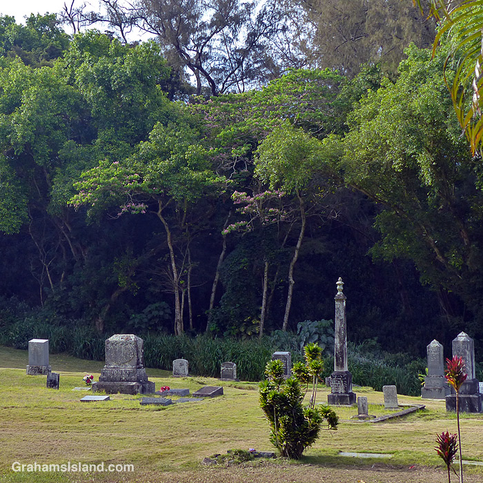
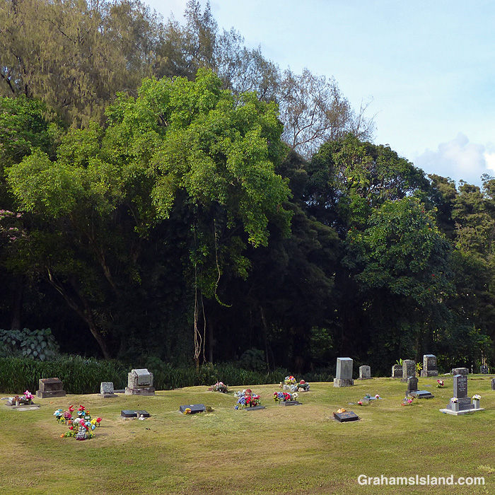
Waianaia Cemetery is a little way east of Kapaau. It sits to the side of the main highway that dead ends at Pololu, 6 miles farther on. While there’s a moderate amount of traffic on this road, the cemetery still has a peaceful feeling, in part because it’s below the road, but also because it’s surrounded by trees.
Waianaia Cemetery is noteworthy because the Bond family is buried there. Reverend Elias Bond and his wife Ellen, were missionaries who came to Kohala in 1841 and lived there for the remainder of their lives. Bond, and his offspring, had a significant impact on the district of North Kohala and the changes it went through. The family owned their missionary station for more than 150 years. It was the only one in Hawaii with such a distinction.
Posted in response to Becky’s July Squares challenge theme of ‘Trees.’ See more responses here.
The engine, prop shaft, and propeller of the SS Kauai, an old wooden steamship, that sank in 1913. Now it’s home to a variety of fish and is a moderately popular dive site.
This is the sixth of my rainbow colors in response to Becky’s April Squares challenge theme of ‘Bright.’ (See more responses here.)
Today’s rainbow arches above Lapakahi State Historical Park in North Kohala. Lapakahi was an old Hawaiian fishing village and the ruins give some insight into the life and culture of those people.
Second is a blue offering hanging outside the predominantly red and green Old Hawaiian Trading Company in Kapaau.
Third is all that’s left of the Bank of Hawaii in Kapaau. The bank used to occupy the whole building, but it’s now used as a senior center.
The third of my rainbow colors in response to Becky’s April Squares challenge theme of ‘Bright.’ (See more responses here.)
Today’s rainbow was taken from Kohala Mountain Road and looks down towards the southern edge of Waimea.
In the middle, a bright yellow saffron finch perches on a bare branch of a plumeria. There were zero leaves on this tree and only a few budding flowers, such as the one next to the finch.
And finally, the yellow robe of the painted statue of King Kamehameha I in Kapaau.
Kohanaiki, located just north of Kailua Kona, is my new favorite park here on the island. It’s the home of a popular surf break known as Pine Trees. There’s a long, sandy beach backed by trees offering shade (not pine trees though). It’s an historic area, too, and at the south end of the park is a variety of old Hawaiian structures as well as a garden featuring native plants.
Kalāhikiola Congregational Church dates back to 1855 though the congregation had met in various structures in the area since 1837. The 1855 church was the first to be built of stone and, despite a few mishaps, it survived largely without problems until October of 2006, when a 6.7 magnitude earthquake caused extensive damage. It was rebuilt in the winter of 2009/2010.
Kiholo Bay sits midway between Kailua Kona and Kawaihae on the west side of the Big Island. There are two main access points to the bay. One is via a gravel road south of the Kiholo Scenic Overlook on the main highway. This road takes you down to Kiholo State Park Reserve where there’s a campground and access to the beaches. I usually go that way, but on my last visit I wanted to try the hike from the main road.
There’s an unmarked parking area north of the scenic overlook. From there it’s about a mile to the coast, along a dirt and gravel road. This passes through scrubby trees where it’s likely goats will be encountered. They’re abundant in this area. The private property alongside the road is well marked, as is the public trail through to the beach. This trail comes out near a funky building decorated with things the tide washed in.
I headed to the right, along the beach towards Wainanali’i lagoon. There are a couple of houses along here, a palm-circled pool, and usually a canoe or two under the trees. Beyond the houses, a small bridge traverses a channel which connects the ocean to Wainanali’i fish pond. This is believed to have been built by King Kamehameha I, as part of an extensive fish collection and farming operation in the bay.
A bit farther along, a blue Kiholo Bay Fisheries Management Area sign marks where the trail forks. To the right, inland, it follows the old King’s Trail to Keawaiki. To the left, it hugs the shoreline heading north alongside Wainanali’i lagoon (top photo). The trail is loosely marked with white coral and/or cairns, but it’s not vital to follow them. I stick to the shoreline.
The lagoon is the remnant of a much larger fishpond, which was around 2 miles across and protected by a 20-foot wide lava rock wall. Much of it was destroyed by a lava flow from Mauna Loa’s 1859 eruption. Today, the lagoon is a prime area for seeing green turtles. They haul out on a rocky island marking the mouth of the lagoon and on the spit that separates it from the ocean. This is where they rest so it’s important not to get too close and disturb them. I also usually see turtles in the water. They putter along the edge in blue-green water, which can give them a wavy appearance. Small fish are abundant here and are often seen.
Once at the head of the lagoon I watched humpback whales splashing and slapping offshore. It’s possible to walk down the spit (not disturbing the turtles), and if it’s calm you can wade or swim across the lagoon entrance back to the trail. Following the coast northwards will take you to Keawaiki, but I retraced my steps until I got back to where I first reached the coast. Then I carried on along the beach.
The waves were rolling in, good news for surfers. The beach here is sandy and vegetation borders it. If the tide’s in a bit of paddling is required. On the other side of this, some private houses border the beach including the Bali House and a sprawling, yellow structure. Farther along is the parking area for Kiholo State Park Reserve, back in the trees, followed by the Loretta Lynn house and the campground.
Here, along with several places along the walk, a fair number of birds can be seen including black-crowned night herons, wandering tattlers, Pacific golden plovers, yellow-billed cardinals, and northern mockingbirds.
The southern end of the park is marked by Waia’elepi anchialine pool. Anchialine pools form in volcanic rock and are connected underground to the ocean. The water is brackish, but the pools can be home to a wide variety of species. I saw goats drinking here as well as a variety of birds and insects flying about.
From there, I headed back to the car on the gravel road which parallels the coast and connects to the trail I came down on. My walk was about 5 or 6 miles, but I took more than 4 hours to cover that distance since I do tend to stop a lot!
For more walks worldwide, see Jo’s Monday Walks. Also posted in response to the current Friendly Friday challenge theme of ‘On The Way.’ See more responses here.