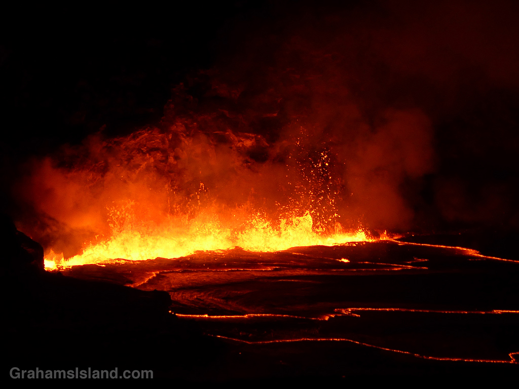
Lava fountains flare up alongside the rim of the active vent in Halemaʻumaʻu Crater at the summit of Kilauea Volcano.
The walls of the crater illuminated by the lava.
This week’s Sunday Stills challenge theme is ‘Mother Earth.’ See more offerings here.
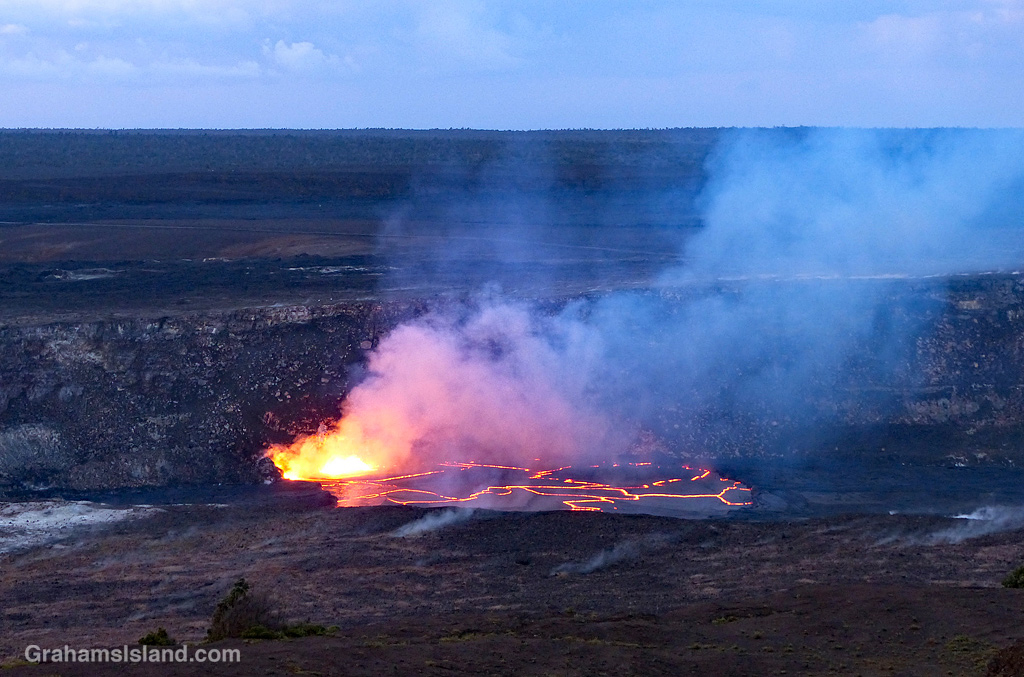
The Big Island is home to Madame Pele, who in Hawaiian culture is the goddess of volcanoes. She is the creator of new land as well as a destroyer. These photos were taken on April 24, 2018. (An account of that visit, and more photos, can be found here.) On May 1, the lava in the lake began to drop. Within a week, it had dropped more than 700 feet and continued falling. Lava had also disappeared from Pu’u O’o, the other active vent on Kilauea.
The drop in lava levels was due to magma in the system moving down the east rift zone of the volcano where it emerged in a series of vents in Leilani Estates, a housing subdivision in the southeast part of the island. This new eruption lasted until late August, 2018, since when the volcano has been quiet.
While there has been no visible activity, below ground, magma has been moving through the system, notably into Kilauea’s summit chamber. It’s surely only a matter of time before Madame Pele makes her presence known again on one of the world’s most active volcanoes.
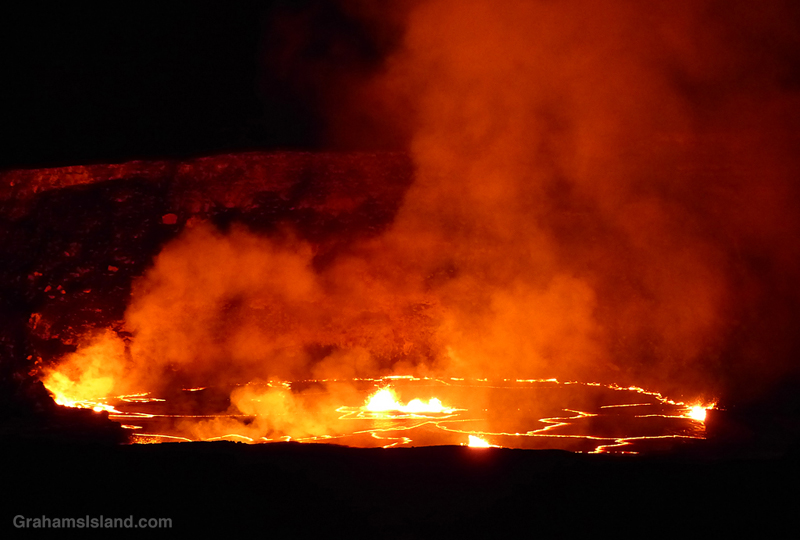
The early morning light shows the crater and land around Halemaʻumaʻu Crater. This is a scene that no longer exists. Since this photo was taken, not only is the vent no longer active, but the crater floor has collapsed numerous times and the walls have also subsided in places.
This is the second part of a three-part description of a hike along the Puna Coast Trail in Hawaii Volcanoes National Park (See part 1 here).
As the trail reaches the coast, it passes over an older flow that has a fair amount of vegetation on it. The third photo shows the trail cutting through a swathe of naupaka, sourbush, and assorted grasses.
This area was, despite the threat of volcanic activity, well occupied by early Hawaiian people. Along the trail are several reminders of that including the structures below. The photo, below middle, shows the amazing abilities of plants to grow in even the most daunting locations. The roots are somewhere deep in the lava, from which the trunk of this noni snakes upward. The large, nobbly fruit can be seen on this plant. This fruit, when ripe, has a pungent aroma which supposedly smells like vomit!
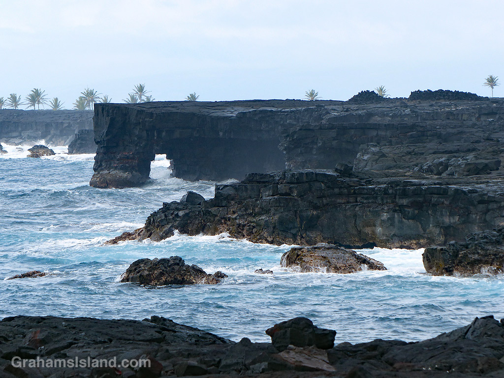
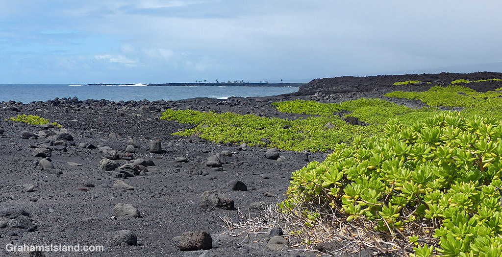
The bottom photo shows an area of rocks and black sand on the coast, backed by an extensive field of naupaka. Beyond that, the trail passes close to a pair of sea arches seen in the top photo and the one at top right. This is a rugged coastline and, when the weather is rough, huge waves can crash up and over the lava. It’s also an unstable coast with rocks and sections of cliff liable to tumble into the ocean.
In the background of the top and bottom photos are the palm trees of ʻĀpua Point, which will be the focus of the third and final post about this trail, tomorrow.
Last month, I posted photos of colorful lava (here) that I saw on a hike I’d just done. In that post, I noted that ‘I’ll do a post about the trail once I’ve gone through the way-too-many photos I took that day!’ With all that’s been going on in the interim, processing those photos took a long time, but now I’m done. So here’s the first of three posts about the trail, not that you can follow in my footsteps right now because Hawaii Volcanoes National Park is currently closed.
As the name indicates, the Puna Coast Trail travels along the coast of the park, but it starts about a mile inland, across Chain of Craters Road from the Pu’u Loa Petroglyphs trailhead. The trail is 11.3 miles long and ends at Halapē campground, but I only hiked as far as ʻĀpua Point, 6.6 miles along the trail. This rugged trail can be hot, windy, and wet so sturdy shoes or boots, a hat, sunscreen, and raingear are a must. There’s no fresh water on the trail so take plenty, as well as enough to eat.
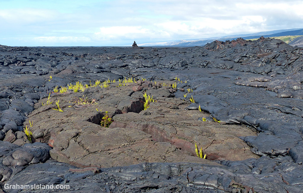
The trail starts by crossing the 1972 flow from an eruption at Mana Ulu. In the top photo, lava from this flow surrounds a small area of older lava. The ferns growing in the cracks are Polypodium pellucidum, an endemic fern known in Hawaii as ae (pronounced Ah Ay). These ferns are among the first plants to grow in new lava fields. The faint outline of the trail can be seen extending from the middle left of the photo to the cairn on the horizon.
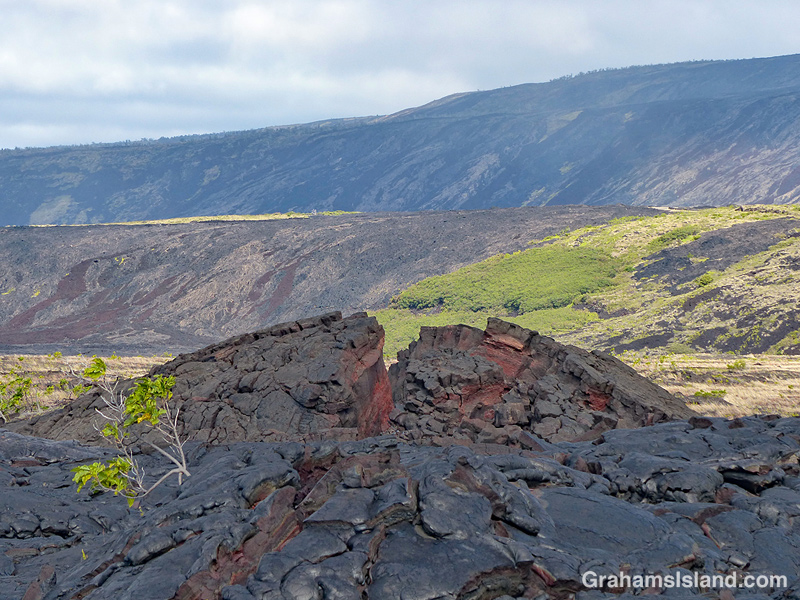
Second photo: An upwelling in an old lava flow has cracked open to reveal a variety of colors within. In the background is Hōlei Pali. A pali is a steep slope or cliff. When a flow goes over a pali, it can often be seen, safely, from a distance away.
Third photo: A trail-marking cairn on a section of older lava that has been somewhat revegetated. The noni (Morinda citrifolia) shrub beside the cairn is another early colonizer of lava flows being tolerant of the harsh conditions found there. Noni is a ‘canoe plant,’ having been introduced to Hawaii by the first Polynesians who arrived in their ocean going canoes.
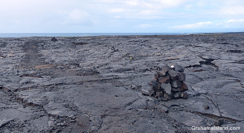
Fourth photo: Cairns mark the trail across the expanse of lava from the 1971 flow, where very little vegetation can be found. This first part of the trail angles down toward the ocean, which can be seen in the distance.
Below: Colorful smooth pahoehoe lava lies on top of ropey pahoehoe lava, from the same 1971 flow. The kind of lava can change quite quickly as conditions change in the flow itself and the terrain it travels through. This also shows the colors in different layers of lava as well as an ae fern getting a toehold.
Bottom: A little hill of pahoehoe lava showing its different forms all jumbled up. I almost included this photo in the earlier post since its colors, textures, and swirls were unexpected art for me.
Tomorrow, part two follows the hike along the coast itself.
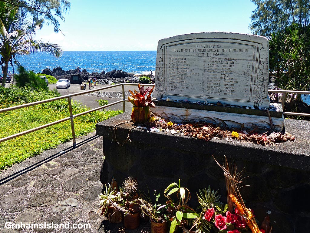
Laupahoehoe is a small community on the Hamakua Coast, 24 miles northwest of Hilo. The name means ‘leaf of lava’ and refers to the low, wedge-shaped cape of pahoehoe lava which juts into the ocean there. That cape is now the site of Laupahoehoe Point Beach Park, but in its early days, this low point of land was the thriving center of the community, with houses, shops, and a school.
On April 1, 1946, all that changed. In the early hours of the morning, there was an earthquake in the Aelutian Islands of Alaska. I’ve seen various reports of the size of that earthquake from 7.1 to 8.6. Some of these variances are due to differing scales in use. The higher numbers refer to the scale in use today, which is moment magnitude, and which more accurately reflects the energy of large earthquakes.
Regardless of the scale, the earthquake generated a huge tsunami, which roared across the Pacific at speeds up to 500 mph. The tsunami reached the east coast of the Big Island around 5 hours later and came ashore as a sequence of three giant waves. In Hilo, the receding water before the third wave, drained Hilo Bay. Then the largest, 55-foot-high wave, thundered ashore. It destroyed much of the town and killed more than a hundred people.
In Laupahoehoe, the same set of three waves occurred. The first two, somewhat smaller waves drenched people and threw fish out of the water. Students from the school were collecting these fish when the third wave struck. 21 students and three teachers were killed and the top photo shows the memorial plaque bearing their names. Only one of the bodies was recovered. Three students survived after being washed out to sea and drifting along the coast for more than a day. An account of their ordeal can be found here.
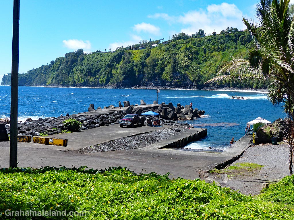
After the tsunami, the community was rebuilt up on the cliffs, which can be seen overlooking the park’s boat ramp and breakwater in the bottom photo. The park is now a peaceful spot with palm trees dotting the shoreline and an expanse of grass where kids can run. But if the tsunami siren sounds, this community has learned that there’s only one way to run, and that’s uphill.
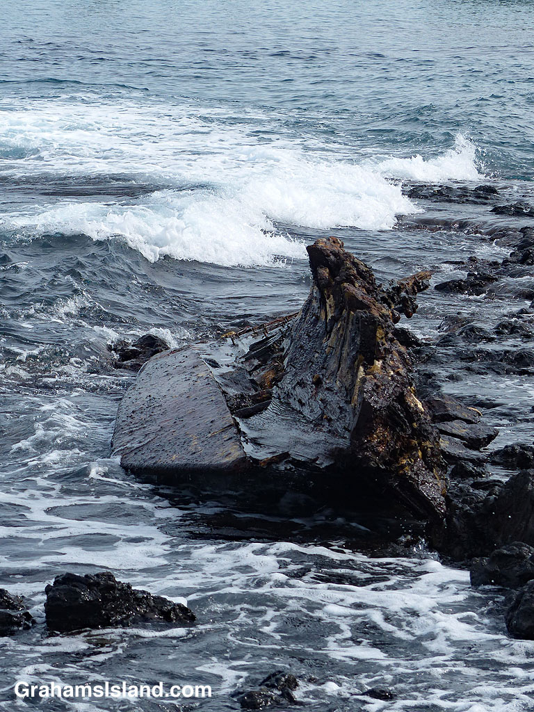
The scant remains of this shipwreck lie on the rocks of Kahuway Bay, just north of the Hualalai Beach Resort on the Kona coast. The keel is still clearly visible along with several keel bolts and the bottom part of the hull. I don’t know which wreck this is, but it’s been there a long time and will probably survive for many years to come.
This week’s Sunday Stills challenge theme is ‘Old.’ See more offerings here.
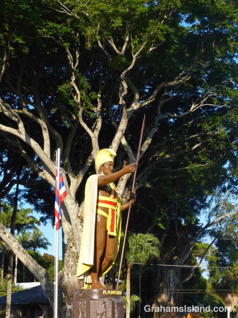
This is the original statue of Kamehameha 1, the king who first united the Hawaiian Islands. The statue was commissioned in 1878, but was lost off the Falkland Islands. A new statue was made, but in the meantime, the original one was salvaged. The new statue was put up in Honolulu and the original shipped to Kapaau.
Not long after I took this photo, the trees in the background were badly damaged during a windstorm and had to be cut down, so this scene looks quite different today.
Kohanaiki Beach Park, north of Kailua Kona, is a favorite spot for surfers. But at the south end of the park, the focus switches to history.
There’s a hālau, Ka Hale Waʽa, which is used for teaching Hawaiian crafts and culture. There’s a garden which grows the same kind of plants brought over by the first Polynesian settlers. And there’s a Hawaiian star compass, a 17-foot diameter recreation showing how the Polynesians used to navigate the vast open spaces of the Pacific Ocean.
The top photo show shows the compass. The middle photo shows a plaque, which explains the basics of how it works, using the points of the compass, the sun, nighttime celestial bodies and the ocean swells. I won’t go into detail here, but more information can be found here, here, and here. Below, the setting of the compass, with a Pacific golden plover walking on it. I like this shot because the plover is said to be the reason Polynesians discovered Hawaii. Each year, plovers summer in Alaska and then fly south as far as New Zealand. It is said that the Polynesians noted this small bird’s annual journey back and forth and figured there must be land somewhere to the north, so they set out in their canoes to find it.
Posted in response to this week’s Sunday Stills challenge on the theme of ‘Round.’ See more offerings here.
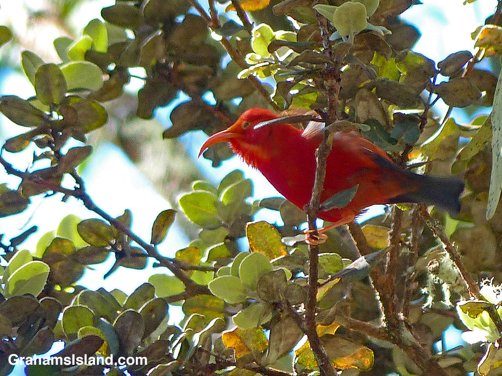
I saw this I’iwi (Drepanis coccinea) on a trail off of Saddle Road, between Mauna Kea and Mauna Loa. These bright red birds are native Hawaiian honeycreepers and in the old days, the feathers of the birds were collected to make cloaks for Hawaiian royalty.
The curved bill is suited for feeding on native lobelias, but a decline in those plants has seen the I’iwi adapt to feeding on other native plants including ʻōhiʻa lehua, māmane, and ohelo.
While the numbers of I’iwi are still fairly good, particularly on the Big Island and Maui, they have suffered, like other birds, from loss of habitat. In addition, They are susceptible to avian malaria, spread by mosquitoes. Consequently, I’iwi are doing better at higher elevations, such as where this photo was taken at around 6,000 feet.