Tag Archives: Lava

Planes landing at Kailua-Kona Airport

Plane landing at Kailua-Kona airport

Hawaii has the reputation of being a tropical paradise, but arriving at Kailua-Kona Airport looks anything but. The final approach to the airport comes over the 1801 Huʻehuʻe lava flow from Hualali volcano. This flow is still quite barren with next to no vegetation. For first-time visitors, touching down on actual tarmac can come as something of a relief.

Exiting the plane, it will most likely be hot, but sunny? Not so much, especially if touchdown is after noon. Typically, clouds roll in during the morning and vog (volcanic smog, caused by pollutants from Kilauea Volcano) settles over the area. The appearance, seen in these photos, is sometimes called ‘concrete skies.’ Not a bad description.

Plane landing at Kailua-Kona

Pu‘u Loa petroglyphs

Not far from the coast, in Hawaii Volcanoes National Park, is Pu‘u Loa petroglyphs trail. It’s only a mile and a half round trip, but visits a place with a huge number of petroglyphs. A raised boardwalk circles part of this area, giving a good view of the petroglyphs without adversely impacting them.

One of the main features of this area and its petroglyph field is explained on a display seen in the second photo. It reads, ‘The name Pu‘uloa (large hill) carries a kaona (hidden meaning)—hill of long life. Families with genealogical ties to these lands come here to place the piko (umbilical cord) of their child. Their hope is that the mana (spiritual guiding energy) of Pu‘uloa would bless that child with a long and prosperous life, and root them to their ancestral lands. Each puka (hole) is created to house a single child’s piko. Of over 23,000 petroglyphs found at Pu‘uloa, 16,000 are piko-related carvings—a testament to the importance of both Pu‘uloa and ‘ohana (family).’

For more information about Pu‘u Loa petroglyphs, go to https://www.nps.gov/havo/learn/historyculture/puuloa.htm.

(On the park’s website, Pu‘u Loa is two words, but on the sign it is one word, hence the inconsistency.)

Sriracha the Bengal tiger

Sriracha, a female Bengal tiger, paces at Pana‘ewa Rainforest Zoo in Hilo.

This week’s WordPress photo challenge is to choose your favorite photo taken in 2017. I’m going with a photo that I haven’t posted before (though below I offer a few of my favorites that have run).

This is Sriracha, a female Bengal tiger and cousin of Tzatziki, a white male tiger. Both can be found at Pana‘ewa Rainforest Zoo in Hilo. What I like about this photo is those huge paws, the quiet movement, and the sense of great power that could be uncoiled at any moment.

For more information about Pana‘ewa Rainforest Zoo & Gardens, go to hilozoo.org.

As far as favorite photos already posted are concerned, I offer a few here:

Top. A gold dust day gecko drinking from a bird of paradise flower is a blaze of color (posted here).

Second. This photo captures the awesome spectacle of the lava firehose from Kilauea Volcano pouring into the ocean (posted here). Currently, while the flow is still active, lava is no longer entering the ocean.

Third. I was happy to snap the moment a passion vine butterfly laid an egg (posted here). This was taken on the same day as the gecko photo above, so a banner day for me.

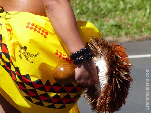
Fourth. I like all the photos in this post for their color and how they capture something of this most Hawaiian of dance (posted here).

Finally, I love this gargantuan blenny for its name, and was very pleased to get this photo, since the fish is apt to dart away and the shallow water was rocking (posted here).

Kilauea Iki Crater trail

A group of people, looking very small, walk the trail across Kilauea Iki Craterfloor.A group of people, looking very small, walk the trail across Kilauea Iki Craterfloor.

These views of the trail across Kilauea Iki Crater, taken from the rim of the crater, give some idea of the scale of Kilauea Volcano.

Above, a group of people, looking very small, walk the trail across the crater floor.

To the left, smoke and gases from the active vent in Halema’uma’u Crater can be seen. Halema’uma’u Crater is part of the Kilauea Caldera which is much, much bigger than Kilauea Iki Crater. And, yes, that same group is still visible on the trail in this second photo, along with several others hiking the trail.

For more information about Hawaii Volcanoes National Park, go to nps.gov/havo/. For more information about Kilauea Volcano and it’s eruptions, go to hvo.wr.usgs.gov/kilauea/history/main.html.

Kona lava tube

The lava tube north of Kailua Kona Airport.The lava tube north of Kailua Kona Airport.

Probably the most visited lava tube on the Big Island is Thurston Lava Tube in Hawaii Volcanoes National Park. However, the most easily accessible might be one just a couple of miles north of the airport at Kailua Kona.

Just off the main highway, it’s not unusual to see a line of vehicles pulled over and people scrambling over the lava. There’s a well worn path leading down to the entrance of the tube and enough headroom to make access easy. However, it’s worth noting that there are piles of rock strewn around from ceiling collapses and the whole area looks crumbly. I certainly wouldn’t want to be down there during an earthquake. Enter at your own risk!