Tag Archives: Lava

Puna Coast Trail: From the trailhead toward the coast

Last month, I posted photos of colorful lava (here) that I saw on a hike I’d just done. In that post, I noted that ‘I’ll do a post about the trail once I’ve gone through the way-too-many photos I took that day!’ With all that’s been going on in the interim, processing those photos took a long time, but now I’m done. So here’s the first of three posts about the trail, not that you can follow in my footsteps right now because Hawaii Volcanoes National Park is currently closed.

As the name indicates, the Puna Coast Trail travels along the coast of the park, but it starts about a mile inland, across Chain of Craters Road from the Pu’u Loa Petroglyphs trailhead. The trail is 11.3 miles long and ends at Halapē campground, but I only hiked as far as ʻĀpua Point, 6.6 miles along the trail. This rugged trail can be hot, windy, and wet so sturdy shoes or boots, a hat, sunscreen, and raingear are a must. There’s no fresh water on the trail so take plenty, as well as enough to eat.

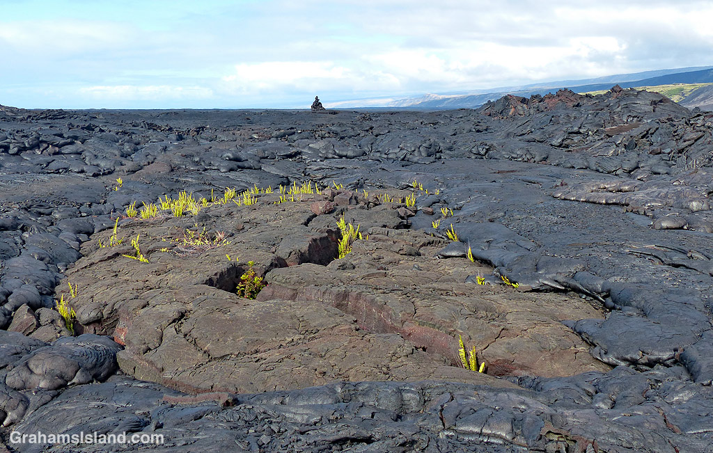
The trail starts by crossing the 1972 flow from an eruption at Mana Ulu. In the top photo, lava from this flow surrounds a small area of older lava. The ferns growing in the cracks are Polypodium pellucidum, an endemic fern known in Hawaii as ae (pronounced Ah Ay). These ferns are among the first plants to grow in new lava fields. The faint outline of the trail can be seen extending from the middle left of the photo to the cairn on the horizon.

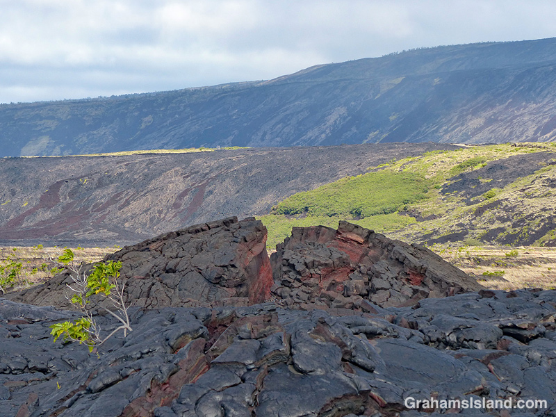
Second photo: An upwelling in an old lava flow has cracked open to reveal a variety of colors within. In the background is Hōlei Pali. A pali is a steep slope or cliff. When a flow goes over a pali, it can often be seen, safely, from a distance away.

Third photo: A trail-marking cairn on a section of older lava that has been somewhat revegetated. The noni (Morinda citrifolia) shrub beside the cairn is another early colonizer of lava flows being tolerant of the harsh conditions found there. Noni is a ‘canoe plant,’ having been introduced to Hawaii by the first Polynesians who arrived in their ocean going canoes.

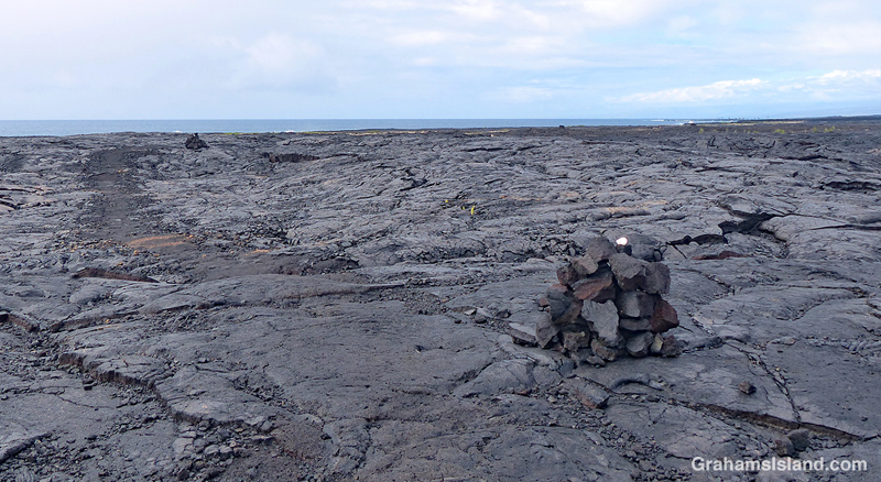
Fourth photo: Cairns mark the trail across the expanse of lava from the 1971 flow, where very little vegetation can be found. This first part of the trail angles down toward the ocean, which can be seen in the distance.

Below: Colorful smooth pahoehoe lava lies on top of ropey pahoehoe lava, from the same 1971 flow. The kind of lava can change quite quickly as conditions change in the flow itself and the terrain it travels through. This also shows the colors in different layers of lava as well as an ae fern getting a toehold.

Bottom: A little hill of pahoehoe lava showing its different forms all jumbled up. I almost included this photo in the earlier post since its colors, textures, and swirls were unexpected art for me.

Tomorrow, part two follows the hike along the coast itself.

For more information about Hawaii Volcanoes National Park, go to nps.gov/havo/. For more information about the Puna Coast Trail, go to bigislandhikes.com/puna-coast-trail.

Colorful pahoehoe lava

This week’s Friendly Friday challenge theme is ‘Art Unexpected.’ See more responses here.

This was a timely topic since, a couple of days ago, I went for a hike in Hawaii Volcanoes National Park. I headed out on the Puna Coast Trail, one of several longer trails west of Chain of Craters Road, that I haven’t explored before. (I’ll do a post about the trail once I’ve gone through the way-too-many photos I took that day!)

One of the highlights of the trail was the extensive areas of colorful pahoehoe lava. I’ve lived here a while now and I know lava doesn’t just come in basic black. I’ve seen lighter and darker flows; I’ve seen flows with a brown tint; I’ve seen flows with hints of red or green in them. But prior to this hike, I had never seen flows with such a variety of vibrant colors.

Instant Hawaii has a description of different types of lava (here) and they say “All the differences in pahoehoe flows stems completely from the temperature of the lava as well as chemical composition. Since both can change during a flow – it is possible to get all types of pahoehoe flowing from a single flow, over time.” I would also say that, what they call ‘quiet flow’ lava, is an apt description of these areas. When I was walking over them I thought they seemed harder and more metallic than the surrounding black pahoehoe lava, which tends to crunch a bit when walked on.

But the other thing I thought, as I found myself continually stopping, stooping, snapping photos, was that these flows were art, Madame Pele’s art, and that wasn’t something I was expecting when I set out on the hike.

For more information about Hawaii Volcanoes National Park, go to nps.gov/havo/.

Pohoiki beach

The Big Island’s newest black sand beach, at Pohoiki, was formed during last year’s eruption of Kilauea Volcano. Soon after its formation, offerings appeared at the beach and coconuts were planted.

For coconut planting, all that’s required is to plunk an unhusked coconut on the beach and wait. The coconut will sprout, as in these photos, but it can still be moved after it has sprouted as its roots are mostly fairly shallow. It’s tolerant of salinity, but likes regular rainfall, both of which are features of this location.

In several years, this somewhat stark black sand beach will become another scenic palm-lined tropical beach. That’s assuming the volcano doesn’t send another flow in this direction, in which case it might look more like the background of the bottom two photos.

Firehose of lava

This week’s Friendly Friday challenge theme is ‘Dramatic.’ See more responses here.

I’ve opted for a dip into the archives for this challenge. Two years ago, lava from Kilauea Volcano’s Pu’u O’o vent reached the ocean, tumbling down a cliff into the water. One day, the cliff collapsed, leaving the lava shooting out of a hole high up in the new cliff. This was called the firehose of lava because that’s what it looked like.

I first learned about it when I saw a video of the lava firehose on one of the news channels. What impressed me was that it was really hard to to see that it was a video. The flow was so strong and so consistent that it looked like a photograph. It was only by looking closely at the edges of the firehose that I could make out spatters of moving lava.

I headed down to the volcano, to take at look at this phenomenon, the day after I saw the video and was duly impressed by the dramatic scene. It was well worth the trip and well worth my quick visit. The following day another cliff collapse moved the firehose back and out of sight from the observation areas.

These are two photos from that visit. More photos can be seen in previous posts here, here, here, and here.

Pohoiki road closed

This week’s Sunday Stills challenge theme is ‘Lines and Squares.’ See more offerings here.

This is one of the roads in Isaac Hale Beach Park at Pohoiki. This park is where last year’s lava activity came to a halt leaving a wall of lava making a border to the public area of the park. Walking beyond the ‘No Trespassing’ sign won’t result in your immediate arrest, but the powers that be don’t want people walking on the flow itself.

But this is a road after all and the sign makes it seem likely that someone driving here might continue on and run into the flow. Actually, this is entirely possible, given how some people drive around here.

Regardless of the intent, I like how the lines on the road disappear into the lava and the red squares are warning signs.

Electric

This week’s Friendly Friday challenge theme is ‘Electric.’ See more responses here. These three photos are quite different, but linked by this theme.

The top photo shows a view of an electric substation. I like the lines and shapes such facilities offer. But where does this power come from? A good deal is from oil fired plants, but Hawaii is working to get more of its electricity from locally sustainable sources.

In the middle is a view of Hawi wind farm, with Mauna Kea in the background. There are several wind farms of varying sizes in Hawaii including a few on the Big Island. Their contribution to the power grid is small, but growing. Solar power is also a big contributor, on an individual house basis or for whole communities (here).

One source that provided around 25% of the Big Island’s electricity was the Puna Geothermal Venture (PGV). Last year’s eruption shut them down, though, as the bottom photo shows, the flows mostly missed the plant itself. I think a couple of their wells were covered by lava, but most were spared. Currently, they’re in the process of restarting power production. Not everyone here is a fan of this power source. The same can be said about the Honua Ola bioenergy plant, which will generate electricity from burning eucalyptus chips, but which is still to become operational.

Fissure 8

This time last year, the newest eruption of Kilauea Volcano was still going strong in the Puna district of the Big Island. The previously active vents, in Halemaumau Crater and at Pu’u O’o, drained of lava at the end of April. Lava then moved underground, down the east rift zone, toward the southeast tip of the island. It resurfaced in May in Leilani Estates.

By the end of May, 24 fissures had discharged lava. Two of those sent flows down to the coast, but at the end of May the main eruption settled on Fissure 8. A river of lava flowed northeast, inundating Highway 132 and reaching the ocean at Kapoho Bay in early June. This flow continued into August, but by the end of that month all activity had more or less ceased. In all, more than 700 homes were destroyed during the eruption, but more than 800 acres of new land had been formed.

These photos show Fissure 8, the source of the main flow. The top photo shows Fissure 8’s location, bordered by houses in Leilani Estates that escaped destruction during the eruption. In the middle, the main crater and the ‘canal’ that channeled the flow toward the coast. Below, another view of Fissure 8 and the wasteland of destruction surrounding it.

PBS’s NOVA put out a show about the eruption earlier this year with some great information about what was actually going on during the eruption. It might be accessible on their site, PBS.org, or search online for the title of the show: PBS Nova Kīlauea: Hawaiʻi on Fire.

Red-billed leiothrix

A red-billed leiothrix perched on a branch in a kipuka on the Pu’u O’o trail off Saddle Road. A kipuka is an area of land that has been surrounded by a lava flow. Kipukas often contain older trees and other plants that are a haven for native and non-native birds and other creatures.

This leiothrix had an exceptionally red bill because it was carrying a bit of ripe thimbleberry, presumably to young birds in a nest nearby.