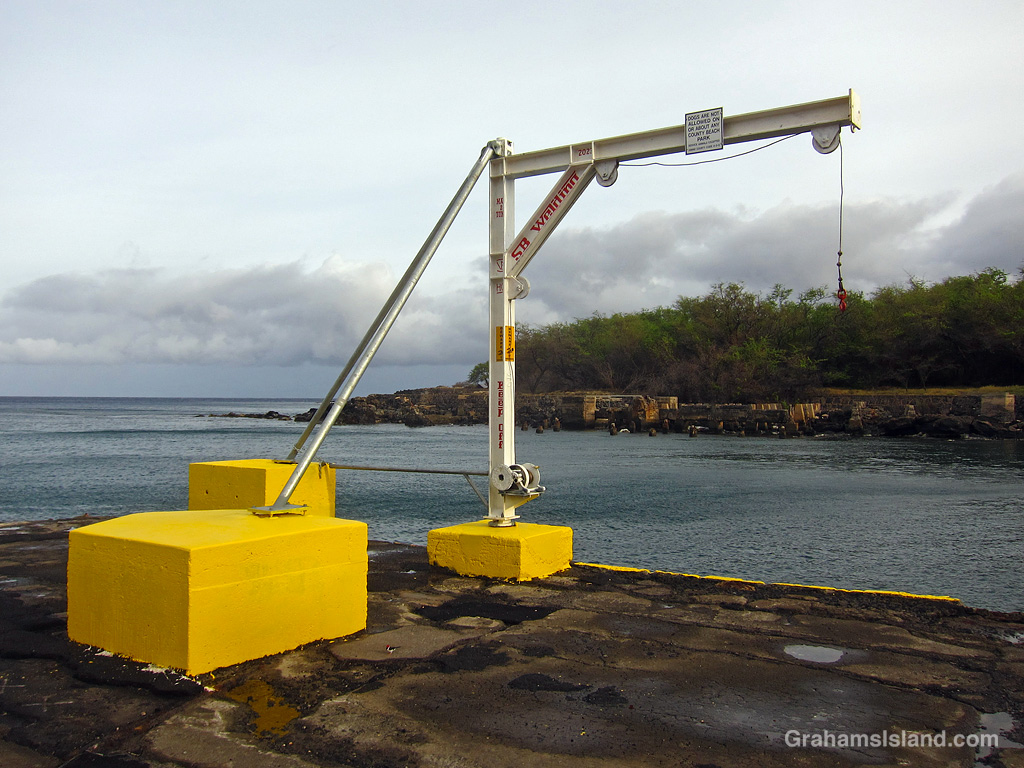
The idea of The Numbers Game is to enter a number into the search bar of your computer and then post a selection of the photos that turn up. This week’s number is 205. Captions are on the photos. You can see more responses here.
Also posted for Becky’s Squares: Simply Red. See more responses here.
Brown Anole.Full Moon.On a guided hike at the Kahuku section of Hawaii Volcanoes National Park.Heliconia Colgantea.Dwarf Date Palm.Clerodendrum Inerme.
This week’s Sunday Stills challenge theme is ‘Flags.’ See more responses here.
In Hawaii, there are usually two flags flown. The top one here is the well-known national flag. The other is Hawaii’s state flag, the only state flag to contain the flag of another country. But how did the Union Jack get there?
This comes down to interactions, in the early days of western contact with Hawaii, between the British Royal Navy and King Kamehameha, who at that time ruled only the Island of Hawaii, not the whole island chain. Kamehameha already had already taken into his inner circle, and thought highly of, a pair of British sailors who acted as military advisors. Then, in 1794, Captain George Vancouver signed a pact with Kamehameha, which he thought ceded the island to Great Britain. That wasn’t how the Hawaiians interpreted it. They thought it established the island as a protectorate. However, one aspect of this exchange was that a British flag was given to the king and was used as a symbol for the kingdom after Kamehameha went on to unite all the Hawaiian islands.
There’s a story that, when the American war of independence with Britain broke out in 1812, Kamehameha did not want to offend either side and so he designed a flag that incorporated elements of both nations’ flags. However the new design came into being, it became the flag of the Hawaiian nation, though the number of stripes, the colors, and the size of the Union Jack often varied.
It wasn’t until 1845 that the current version became official, with the eight stripes representing the eight main islands of Hawaii.
The idea of The Numbers Game is to enter a number into the search bar of your computer and then post a selection of the photos that turn up. This week’s number is 198. Captions are on the photos. You can see more responses here.
A Pink-Spotted Hawkmoth.A House Sparrow on a shiny-looking lanai.Riding a wave.Rosy-faced lovebirds.A Green Hover Fly.Sunrise over Hualalai.
Trails come in all shapes and sizes. Some meander through the woods.
This week’s Sunday Stills challenge theme is ‘Paths and Trails.’ See more responses here.
Some follow the coast.Some wind through barren lava fields.Some pass next to busy roads. Don’t look down!Some are paved and have rails for safety.Some have handy signs.Some are built to carry you above ancient petroglyphs.Some trails are mysterious.Some are clear and easy to follow.And with some, it’s a long way down, and twice as long coming back up!
A lava breakout in a flow from Pu’u O’o covers the old coast road, which is now a trail (here).
This week’s Sunday Stills challenge theme is ‘Parks.’ See more responses here.
Hawai‘i Volcanoes National Park is the best known park on the island. It covers 354,461 acres, which includes, not just the Kilauea area, but up to the summit of Mauna Loa and down the southwest rift zone of that volcano. The park contains 106 miles of roads and 155 miles of marked trails, many of them well off the beaten track.
I’ve hiked a lot in the park, though I doubt I’ll ever cover all the trails, but these photos are from ones I’ve done with links to the original posts for those interested.
On the Pu‘u Loa Petroglyphs Trail (here).Great views on the Hilina Pali Trail, but this one nearly did me in! (here).Puʻu ʻŌʻō from the end of the Nāpau Trail (here and here).Puapo’o lava tube is only accessible on a guided tour (here).Nahuku lava tube is one of the most popular stops in the park (here).Kilauea Iki is another popular trail, across the floor of an old vent (here).Steaming Bluff on the Crater Rim Trail (here).The Jaggar Museum viewing point. The museum has gone but the viewing point just reopened (here).Sulphur Banks Trail (here).Halemauma Trail passes through the woods (here).The Puna Coast Trail features colorful lava (here)……As does the Ka’u Desert Trail (here).A lush valley in the Kahuku section of the park (here).
Also posted for Jo’s Monday Walk. See more responses here.
This Gold Dust Day Gecko snagged a moth for lunch.
The idea of The Numbers Game is to enter a number into the search bar of your computer and then post a selection of the photos that turn up. This week’s number is 194. Captions are on the photos. You can see more responses here.
A rusty water tank.A cow alongside the road.The Ala Kahakai Trail near Kohanaiki.Too heavy to drink?A Bird Wrasse.An Hawaii Amakihi taking a break.
The current eruption at Kilauea has been marked by a succession of eruptive events followed by pauses. The more recent of these events have consisted of the volcano putting out some small flows, succeeded by fountaining events with the fountains reaching up to 1,000 feet. I’ve been itching to go down and see this, but the fountaining often hasn’t lasted long. My challenge has been to hear about the activity early and at a time when I can go down. This has not been going well!
Last Sunday, after lunch, I sat down to check my emails and saw the daily USGS update for Kilauea. Apparently, it was stirring again, the 21st episode of the current eruption. I went to the video webcam and saw that it was doing more than stirring. It was launching fountains of lava into the air. Scrolling back on the webcam I discovered that the fountaining had started only 20 minutes earlier.
The 20th episode had been the shortest so far, at 4.5 hours of fountaining. My drive to Kilauea is more than 100 miles, but I figured that even if this was another short one, I’d have an hour or two to see the activity, so I jumped in the car and headed over. I left at 1:30 p.m. and got to the park around 3:45 p.m., finding it under a layer of cloud. The weather had gone downhill since I left and the park was a zoo, cars everywhere, edging around or parked in improbable spots.
Miraculously, I found a parking spot on the north rim of the crater and walked out to see what I could see. The answer was, not much. The weather wasn’t helpful, but the problem, which I suspected might be the case, was that the active vent was close to the north rim and so the activity was largely obscured. The prime viewing area would be a spot on the south rim, but one that was farther away, and low clouds were scudding through the crater. Would anything be visible? There was only one way to find out.
I drove around the crater rim to the other side and found a similarly chaotic parking situation. The park isn’t designed to accommodate parking demands on the scale it was experiencing. Luckily, I found a spot, not that far from the trail I had to take. The trail is actually a road that’s been closed since the summit crater became active in 2008. It’s definitely not usable by vehicles, especially since 2018 when a section of it slid into the crater. The road is still visible on its little island, just a few hundred feet below the rest of it!
The walk in isn’t far, about a mile or so. There was a fair amount of foot traffic, both coming and going. When I got to the viewing area, even though there were quite a few people there, it didn’t feel too crowded. There was a decent view of the erupting vent, a little over a mile away, but it was sadly affected by mist blowing through the crater.
I found a spot, took photos, watched the weather. It looked like it was clearing, then looked like it was getting worse. I was keenly aware of the drive home and that I had to go to work the next day. At one point I decided I’d give it another 15 minutes and if it didn’t improve, I’d head for home. 10 minutes later the clouds had blown through, the sky brightened, and the active vent was clearly visible. The only downside was that the sun was slowly sinking behind the active vent, so the lighting wasn’t the greatest. But I wasn’t complaining.
The visual treat of seeing the activity was wonderful, but there’s also the noise of the eruption, like being next to a busy airport. The fountains of lava in the photos are probably around 400 feet high.
I left the viewing area a little after 6 p.m. and headed for home, getting there around 9 p.m., by which time the activity had already ceased at Kilauea. It ended around 8:30 p.m.. Currently, the eruption is again paused, though the USGS expects the next episode to begin within a few days.
Also posted for Jo’s Monday Walk. A short walk, but well worth doing! See more responses here.
Lava fountaining during the 21st episode of the current eruption at Kilauea Volcano.
The idea of The Numbers Game is to enter a number into the search bar of your computer and then post a selection of the photos that turn up. This week’s number is 193. Captions are on the photos. You can see more responses here.
The top photo is from two days ago, when I finally made it down to Kilauea Volcano to see the latest in a string of eruptions. Hopefully, I will get my photos sorted for a longer post about that in the next day or two.
A bee in the flower of a Cannonball Tree.A Phalaenopsis violacea orchid.A Pinktail Triggerfish.Hapu’u Ferns.Kahili Ginger and raindrops.An old propellor on shore near the boat lauch at South Point.